
Amsterdam-Zuidoost
| province |
|
| local community |
|
|
Area - land - water |
22.11 km 2 20.08 km 2 2.03 km 2 |
| Residents | 87,854 (Jan 1, 2017) |
| Coordinates | 52 ° 18 ′ N , 4 ° 58 ′ E |
| Important traffic route |
|
| prefix | 020 |
| Postcodes | 1014-1015, 1043, 1069, 1082, 1099, 1101-1102 |
 |
|
Zuidoost ( German Southeast ) is a district of the Dutch city of Amsterdam in the province of North Holland . It is 22.11 km² and had 87,854 inhabitants in January 2017. The district is located in the southeast of Amsterdam, but as an exclave does not border on the rest of the municipality of Amsterdam. The Kwakoe Zomer Festival takes place once a year in Zuidoost , the largest multicultural event of its kind in Amsterdam.
history
The heart of Zuidoost is the Bijlmermeer district . Its name goes back to a lake ( Dutch sea ) that was in the village of Bijlmer and was drained in the seventeenth century. The poor conditions of the polded lake for construction measures (high water level, soft soil, susceptibility to flooding) meant that its area was still little built up in the 1960s.
Since Amsterdam reached its limits of growth after the war, the municipality of Weesperkarspel , in which Bijlmer and the Bijlmermeer were located, was incorporated in 1966 in order to use the open area of the former lake as an urban development area. The area of the former municipality then became the Zuidoost district. Since this formed an exclave, it was planned to later also incorporate the intervening municipality of Ouder-Amstel , but this was eventually discarded due to the resistance of the citizens of Ouder-Amstel, whereby Zuidoost remained an exclave.
Even before the incorporation was completed, the soil preparation measures for building projects began in 1963. The new development area should follow Le Corbusier's paradigm of the functional city , according to his study Plan Voisin . Among other things, this provided for the spatial separation of the urban functions of living , working , recreation and traffic (cf. Wohnmaschine ). Of the 18,000 planned residential units, 12,000 were to be built in a honeycomb high-rise complex. The first apartment was occupied in 1968 and the last one was completed within the project in 1975.
Conceptual weaknesses, planning errors and the delayed provision of crucial infrastructure prevented the new building area from functioning from the start and set a downward spiral in motion, which soon earned the area the reputation of the worst residential area in the entire Netherlands. Attempts to reverse the trend only achieved isolated successes.
- El Al flight 1862
On October 4, 1992, a Boeing 747-285F crashed into a residential complex in the Bijlmermeer residential area . 39 residents and 4 crew members died. The affected buildings were demolished, whereby the foundations were preserved. Today the Bijlmer Monument stands near them.
Bijlmermeer large housing estate, 1966–75

Bijlmermeer, Metro
Bijlmermeer, master plan 1965 (Siegfried Nassuth)
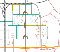
Bijlmermeer 2012, existing buildings (red), broken (gray), see. Google Maps


Residential area
- Bijlmermeer
- Amstel III
- Gaasperdam
- Venserpolder
- Third moon
- Bullewijk (industrial area with 175 inhabitants)
Attractions
The Johan Cruyff Arena is located in Zuidoost .
Recreational areas
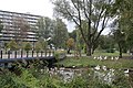
- Bijlmerpark
- Bijlmerweide
- Broekzijdse polder
- Gaasperpark
- Gaasperzoom
- Gaasperplas
- De Hoge Dijk
- Ouderkerkerplas
literature
- Amsterdam Zuidoost. Centrumgebied Zuidoost en stedelijke vernieuwing Bijlmermeer 1992-2010 . Uitgeverij Thoth, Bussum, 2002. ISBN 90-6868-305-5
Web links
- Stadsdeel Zuidoost on the website of the municipality of Amsterdam (Dutch)
Individual evidence
- ↑ a b Kerncijfers stadsdelen 2017 Gemeente Amsterdam, accessed on April 27, 2018 (Dutch)
- ^ Accident description flight 1862
- ↑ Bijlmer district parks
- ^ Bijlmer Monument
Admiralenbuurt | Amsterdam Oud-West | Amsterdam Oud-Zuid | Amsteldorp | Apollobuurt | Betondorp | Banne Noord and Zuid | Bellamybuurt | Bloemenbuurt | Borgerbuurt | Bos en Lommer | Buiksloot | Buikslotermeer | Buitenveldert | Bullewijk | Burgwallen Oude Zijde | Burgwallen Nieuwe Zijde | Chassebuurt | Chinatown | Since Costabuurt | Cremerbuurt | Czaar Peterbuurt | De Aker | De Baarsjes | De Pijp | Diamantbuurt | Third moon | Durgerdam | Duivelseinland | Erasmusparkbuurt | Floradorp | Frederik Hendrikbuurt | Gaasperdam | Geuzenbuurt | Geuzenveld | Gibraltarbuurt | Gouden Real | Gulden Winckelbuurt | Haarlemmerbuurt | Helmersbuurt | Holysloot | Hoofddorppleinbuurt | Houthaven | Indian Buurt | Jan Maijenbuurt | IJburg | Java island | Jeruzalem | Jeugdland | Jodenbuurt | Jordaan | Kadijken | Kadoelen | Kinkerbuurt | KNSM-island | Kolenkitbuurt | Landlustbuurt | Load | Brandengouw | Mercatorbuurt | Molenwijk | Museum Quarter | Negen Straatjes | Nieuwendam | Nieuwmarkt | Oostzanerwerf | Nieuw Sloten | Nieuwe Pijp | Omval | Oostelijk Havengebied | Oostelijke Eilanden | Oosterparkbuurt | Osdorp | Oude Pijp | Overtoomse Veld | Plantation birth | Postjesbuurt | Prineses Irenebuurt | Ransdorp | Rapenburg | Rieteilanden | Rivierenbuurt | Schellingwoude | Robert Scottbuurt | Schinkelbuurt | Sloten | Sloterdijk Centrum | Slotermeer | Slotervaart | Spaarndammerbuurt | Staatsliedenbuurt | Stadionbuurt | Steigereiland | Terrasdorp Hogeland | Transvaalbuurt | Trompbuurt | Tuindorp Buiksloot | Tuindorp Nieuwendam | Tuindorp Oostzaan | Twiske Kadoelen | Uilenburg | Van der Pekbuurt | Vogelbuurt | Vondelparkbuurt | Watergraafsmeer | Westelijke Eilanden | Westelijke Tuinsteden | Westerpark | Willemspark | Zeeburg | Zeeheldenbuurt | Zuidas | Zuideramstel | Zunderdorp