
Bílina
| Bílina | |||||
|---|---|---|---|---|---|
|
|||||
| Basic data | |||||
| State : |
|
||||
| Region : | Ústecký kraj | ||||
| District : | Teplice | ||||
| Area : | 3,251,282 ha | ||||
| Geographic location : | 50 ° 33 ' N , 13 ° 47' E | ||||
| Height: | 207 m nm | ||||
| Residents : | 17,166 (Jan 1, 2019) | ||||
| Postal code : | 418 01 | ||||
| License plate : | U | ||||
| traffic | |||||
| Railway connection: |
Ústí nad Labem – Chomutov Plzeň – Duchcov |
||||
| structure | |||||
| Status: | city | ||||
| Districts: | 6th | ||||
| administration | |||||
| Mayor : | Oldřich Bubeníček (as of 2018) | ||||
| Address: | Břežánská 50/1 418 01 Bílina |
||||
| Municipality number: | 567451 | ||||
| Website : | www.bilina.cz | ||||
| Location of Bílina in the Teplice district | |||||

|
|||||


Bílina (German Bilin ) is a city in the Czech Republic on the Bílina in northwest Bohemia between the cities of Most and Teplice . It belongs to the Okres Teplice , in Ústecký kraj , Czech Republic. The city has been famous as a health resort since the 17th century.
geography
Geographical location

Bílina is located on the north-western slope of the Bohemian Central Mountains at an altitude of 207 meters above sea level . Ten kilometers to the east rises the 836 meter high Milešovka ( Milleschau Mountain ), the highest point in the Bohemian Central Uplands. The river Bílina , a tributary of the Elbe, flows through the city . Former open-cast lignite mining areas adjoin a narrow belt of forests in the northwest and southeast. The European route 442 runs through the city and connects to the neighboring cities of Most and Teplice. The regional capital Ústí nad Labem is 30 kilometers away. Bílina is on the Ústí nad Labem – Chomutov railway line . The German-Czech border runs 20 kilometers as the crow flies on the Ore Mountains ridge.
City structure
The town consists of the districts Bílina Bílina ( Bilin ) Chudeřice ( Kutterschitz ) Mostecké předměstí ( Brüx suburb ), Pražské předměstí ( Prague suburb ), Teplické předměstí ( Teplice suburbs ) and Újezdské předměstí ( Ujester suburb ). Basic settlement units are Bílina-střed, Břešťany ( Preschen ), Doly Bílina-Břežánky, Elektrárna Ledvice, Hradiště, Chlum, Chudeřice, Jenišův Újezd ( Langugest ), Lázně Kyselka ( Bad Sauerbred, Válněstý Nátríně, Vártyříž), , Pod Bořeněm, Pražské Předměstí, Radovesická výsypka, Srbsko, Teplické Předměstí, U nádraží, Újezd ( Ujest ), Za Chlumem I, Za Chlumem II and Za nemocnicí. The municipality is divided into the cadastral districts of Bílina, Bílina-Újezd, Břešťany , Břežánky ( Briesen ), Chudeřice u Bíliny and Jenišův Újezd .
history

.jpg)

The first settlement took place in the 6th century by the Slavs . The Bilinian dynasty ruled here until the 10th century. In the 10th century the Přemyslids took power. The first written mention can be found in the papal tax bulletin of 993. This is the first time the "provincia Belinensis" is mentioned. In the 12th century it was mainly the Hrabish who ruled the area. The initially private "Church of Saints Peter and Paul" from 1061 now assumed the function of a parish church. In 1169 King Wladislaw I gave Bilin to the Order of St. John . From the 13th century onwards, Bilin had developed into a regional center. When King Wenzel I gave the place to the ogre von Friedeberg in 1237 , Bilin came under the rule of German landlords for the first time. In 1263 the place was raised to a city.
From 1290 Albrecht von Seeberg became the owner. The hospital he founded and the patronage of the Church of St. Peter and Paul were taken over by the German Order in 1302 . In 1342 he also built a Latin school in the city, which was mostly inhabited by the German population. Otto II von Bergow built Geiersberg Castle ( Kyšperk Castle ) in 1319 . At that time, a large wine-growing region had developed near the city. At the end of the 14th century, Otto the Elder from Bergow bought Bilin.
The era of German rule came to an end in 1407 when King Wenzel IV gave the city to the Bohemian nobleman Albrecht von Kolditz from Graupen . After the Hussite Wars , in which the city and castle were conquered by the Hussites in 1421 , the Saxon line of Colditz took over the city in 1436 . In 1549, Bilin received the city coat of arms from the Austrian Emperor Ferdinand I. Around 1470, Hoger von Friedberg had a castle built on the site of today's castle.
In 1513 he was inherited by the lords of Lobkowicz as owners of the castle and lands. The city began to flourish in the 16th century, and numerous handicraft businesses settled here. In 1568 a major fire destroyed numerous houses and the church; the damage was quickly repaired. In the Thirty Years' War Swedish troops destroyed the castle and most of the houses. It took the city 30 years to repair the war damage. The Italian architect Antonio della Porta built the new baroque palace in 1675–1682. Under the rule of Eleonora von Lobkowicz, the spa was built in the Bad Sauerbrunn district (today Lázně Bílinská Kyselka ). The spa doctor and balneologist Franz Ambrosius Reuß created the first balneological writings on the local, medicinally used mineral water Biliner Sauerbrunn and Saidschitzer Bitterwasser . Prominent spa guests included Alexander von Humboldt , Johann Wolfgang von Goethe and Ludwig van Beethoven .

In 1750 coal mining began in the nearby Kutterschitz ( Chudeřice ). At the end of the 18th century the bathing business was expanded and industry settled down. The walls of the castle standing in the way were removed. Prince Lokowitz had a large sugar factory built in 1835, in 1866 Bilin was connected to the railway, lignite mining began in the St. Emmeran colliery, and in 1893 the Engels glassworks was founded. Bilin became a garrison town of the Austro-Hungarian army . In 1914, the 1st Battalion of Field Cannon Regiment No. 20 was stationed here. The proportion of the Czech population also grew. While their share was only 7.5% in 1880, it increased to 19.5% with 9,000 inhabitants by 1910.
As a result of the First World War , Bilin came to the newly founded Czechoslovakia . After the city was occupied by Czechoslovak soldiers, the German people founded a people's armed forces for their own protection. On December 1, 1930, the city of Bilin had 10,688 inhabitants, of whom 4,168 were Czech. On the basis of the Munich Agreement of September 29, 1938, Bilin was added to the German Reich, and on October 10, 1938, German soldiers entered the city. From 1939 on, Bilin belonged administratively to the Reichsgau Sudetenland and was the seat of the district of Bilin in the administrative district of Aussig . Many Czech residents were expelled to the " remaining Czech Republic ", so that the number of inhabitants fell to 9,125 by May 17, 1939. On April 1, 1944, the municipality of Kutterschitz was incorporated into the city of Bilin.
After the end of the Second World War , Czechoslovakia emerged again within the borders of 1938. In 1945/1946, most of the German residents were expelled due to the Beneš decrees . The name of the city was changed to Bílina. On May 22, 1947 7915 residents were counted, by 2005 the number of residents increased to 15,714. On November 1, 1970, the municipality of Břežánky was incorporated and devastated until 1972 because of the large open-cast mine důl Maxim Gorkij .
Population development
Until 1945, Bilin was predominantly populated by German Bohemia , which were expelled.
| year | Residents | Remarks |
|---|---|---|
| 1830 | 2,381 | in 383 houses |
| 1900 | 7,871 | German residents |
| 1930 | 10,688 | including 4,168 Czechs |
| 1939 | 9,139 |
- Historical recordings of Bílina

Biliner Sauerbrunn 1899 (by Franz Skopalik)
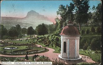
Spa gardens 1906

Mail order company of the Biliner Sauerbrunnen in 1907

Biliner Sauerbrunn 1912


Culture and sights
- Bílina Castle (1675–1682) owned by the Lobkowicz princes
- Church of Saints Peter and Paul (1573–1575)
- Hospital church in Ujezd (1600)
- Hussite Bastion (around 1470)
- Lázně Kyselka ( Bad Sauerbrunn )
- Mount Bořeň ( Borschen ) in the southwest of the city
- synagogue
- Jewish Cemetery

spa

The old bathroom

Church of St. Peter and Paul

Street line

synagogue
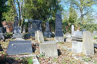
Jewish Cemetery


_(2).jpg)
.jpg)


Economy and Infrastructure
Open pit lignite mining, power station, glass industry, agriculture, Kyselka spa area.
Personalities
sons and daughters of the town
- Johann Adalbert Angermayer (1674–1742), painter
- Wenzeslaus Jorhan (around 1695–1752), sculptor
- August Emanuel von Reuss (1811–1873), Austrian geologist and paleontologist
- Gustav Walter (1834–1910), opera singer and chamber singer of the Vienna Court Opera
- Hans Watzek (1848–1903), Austrian photographer
- Wilhelm Biedermann (1852–1929), Bohemian physiologist
- Edmund Wünsch (1894–), lute singer and composer
- Erika Streit (1910–2011), Swiss painter, graphic artist and draftsman
- Miloslav Stingl (1930–2020), Czech ethnologist and non-fiction author
More people
Sorted by year of birth
- Jakob von Wrzessowitz († around 1461), Moravian military leader and diplomat, was a captain here during the Hussite period
- Christoph Theodor Aeby (1835–1885), anthropologist
- Josef Tschan (1844–1908), lawyer, member of the Bohemian state parliament
- Karl-Heinz Plattig (* 1931), physiologist, honorary citizen of Bílina
- Štěpán Vachoušek (* 1979), Czech football player, played for Lokomotiva Bílina
Twin cities
-
 Biłgoraj , Poland
 -
 Dippoldiswalde , Saxony, Germany
literature
- Georg Wodraschke: A walk through the home district of Bilin. Local district association Bilin, Gerolzhofen 2010.
Web links
- City website (Czech, German, English)
- Chronicle at Heimatkreis Bilin ( MS Word ; 2.9 MB)
Individual evidence
- ↑ http://www.uir.cz/obec/567451/Bilina
- ↑ Český statistický úřad - The population of the Czech municipalities as of January 1, 2019 (PDF; 7.4 MiB)
- ↑ http://www.uir.cz/zsj-obec/567451/Obec-Bilina
- ↑ http://www.uir.cz/katastralni-uzemi-obec/567451/Obec-Bilina
- ↑ Johann Gottfried Sommer : The Kingdom of Bohemia . Volume 1: Leitmeritzer Kreis , Prague 1833, p. 118, item 1).
- ↑ Yearbooks of the Bohemian Museum of Natural and Regional Studies, History, Art and Literature . Volume 2, Prague 1831, p. 197, item 8).
- ^ Meyer's Large Conversational Lexicon . 6th edition, Volume 2, Leipzig and Vienna 1905, p. 875 .
- ^ A b Michael Rademacher: German administrative history from the unification of the empire in 1871 to the reunification in 1990. Bilin district. (Online material for the dissertation, Osnabrück 2006).
- ↑ Prof. Karl-Heinz Plattig on his 70th birthday (FAU Erlangen)