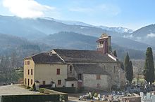
Brassac (Ariège)
|
Brassac Braçac |
||
|---|---|---|
|
|
||
| region | Occitania | |
| Department | Ariège | |
| Arrondissement | Foix | |
| Canton | Val d'Ariège | |
| Community association | Pays Foix-Varilhes | |
| Coordinates | 42 ° 57 ' N , 1 ° 32' E | |
| height | 447-1,716 m | |
| surface | 24.33 km 2 | |
| Residents | 632 (January 1, 2017) | |
| Population density | 26 inhabitants / km 2 | |
| Post Code | 09000 | |
| INSEE code | 09066 | |
| Website | http://brassacariegepyrenees.jimdo.com/ | |
Brassac ( Occitan : Braçac ) is a place and a municipality in the south of France with 632 inhabitants (as of January 1, 2017) in the Ariège department in the Occitania region (before 2016: Midi-Pyrénées ); it belongs to the Arrondissement Foix and the canton Val d'Ariège (until 2015: canton Foix-Rural ). The inhabitants are called Brassacois .
location
Brassac is about 19 kilometers south-southwest of Pamiers and about six kilometers west-southwest of Foix . The Arget River limits the municipality to the northeast. Brassac is surrounded by the neighboring communities Serres-sur-Arget and Bénac in the north, Saint-Pierre-de-Rivière in the north-east, Ganac in the east, Saurat in the south, Le Bosc in the west and Burret in the north-west.
Population development
| year | 1962 | 1968 | 1975 | 1982 | 1990 | 1999 | 2006 | 2013 |
| Residents | 428 | 408 | 339 | 530 | 555 | 584 | 599 | 642 |
| Source: Cassini and INSEE | ||||||||
Attractions
- Saint-Etienne church
- Brassac Castle
- Castle, converted into a palace in the 16th century, tower from the 12th century
- Devil's bridge
- Wash house from 1921
Web links
Commons : Brassac - collection of images, videos and audio files

