
Mercus Garrabet
|
Mercus-Garrabet Mèrcus, Garravet e Amplanh |
||
|---|---|---|
|
||
| region | Occitania | |
| Department | Ariège | |
| Arrondissement | Foix | |
| Canton | Sabarthès | |
| Community association | Pays de Tarascon | |
| Coordinates | 42 ° 53 ' N , 1 ° 38' E | |
| height | 432-1,603 m | |
| surface | 14.79 km 2 | |
| Residents | 1,199 (January 1, 2017) | |
| Population density | 81 inhabitants / km 2 | |
| Post Code | 09400 | |
| INSEE code | 09188 | |

Mercus-Garrabet ( Occitan : Mèrcus, Garravet e Amplanh ) is a French commune with 1,199 inhabitants (as of January 1, 2017) in the Ariège department in the Occitania region (before 2016: Midi-Pyrénées ). The municipality belongs to the Arrondissement Foix , the canton Sabarthès (until 2015: canton Tarascon-sur-Ariège ) and the municipality association Pays de Tarascon, founded in 1994 . The inhabitants call themselves Mercusiens-Garrabetois .
geography
Mercus-Garrabet is located about nine kilometers south-southeast of Foix in the Pyrénées Ariégeoises Regional Nature Park on the Ariège . Mercus-Garrabet is surrounded by the neighboring communities of Montoulieu in the north and north-west, Saint-Paul-de-Jarrat in the east and north-east, Cazenave-Serres-et-Allens in the south-east, Arnave and Bompas in the south and Arignac in the west.
The National Route 20 runs through the municipality .
Population development
| year | 1962 | 1968 | 1975 | 1982 | 1990 | 1999 | 2008 | 2014 |
|---|---|---|---|---|---|---|---|---|
| Residents | 586 | 869 | 944 | 972 | 925 | 1.005 | 1,119 | 1,144 |
| Source: Cassini and INSEE | ||||||||
Attractions
- Saint-Louis de Mercus church from the 12th century, monument historique since 1910
- Garrabet Devil's Bridge
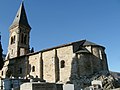
Saint-Louis church

Devil's bridge

.JPG)