Verdun (Ariège)
| Verdun | ||
|---|---|---|
|
|
||
| region | Occitania | |
| Department | Ariège | |
| Arrondissement | Foix | |
| Canton | Haute-Ariège | |
| Community association | Haute Ariège | |
| Coordinates | 42 ° 48 ′ N , 1 ° 41 ′ E | |
| height | 513-1,461 m | |
| surface | 11.71 km 2 | |
| Residents | 221 (January 1, 2017) | |
| Population density | 19 inhabitants / km 2 | |
| Post Code | 09310 | |
| INSEE code | 09328 | |
| Website | Verdun (Ariège) | |
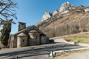
 Church Saint-Julien |
||
Verdun ( Occitan : identical) is a mountain village and a small southern French municipality ( commune ) with 221 inhabitants (as of January 1, 2017) in the Ariège department in the Occitania region .
location
The place Verdun is at an altitude of about 560 meters above sea level. d. M. in the valley of the Ariège at the foot of the Pyrenees . The health resort of Ax-les-Thermes is about 16 kilometers (driving distance) in a south-easterly direction; the cities of Foix and Pamiers are approximately 28 and 48 kilometers north, respectively.
Population development
| year | 1962 | 1968 | 1975 | 1982 | 1990 | 1999 | 2006 | 2012 |
| Residents | 247 | 210 | 184 | 160 | 154 | 183 | 237 | 228 |
In the 19th century the place had mostly between 400 and 750 inhabitants. The phylloxera crisis in the wine and the mechanization of agriculture led to a loss of jobs and a continuous decline in population numbers down to the lows of the 1980s from the late 19th and 20th centuries.
economy
The inhabitants of Verdun live mainly from agriculture (milk and cheese production); viticulture is also practiced on a small scale. In the late Middle Ages, the gold panning in the Ariège river bed is mentioned; there were also several watermills here . Nowadays tourism - also in the form of renting holiday homes ( gîtes ) - plays an important role in the economic life of the small community.
history
The place name is first mentioned in 988 as part of a donation of territory by Rogers I , Count of Carcassonne , to the Abbey of Saint-Volusien in Foix; the abbey property is in a document of Pope Honorius III. Confirmed from 1224. In the years between 1318 and 1325, an inquisition tribunal under the direction of the Bishop of Pamiers met in town for a total of 370 days . Both in 1613 and 1875 floods of the Ariège and mud and debris avalanches from the nearby mountain slope caused severe damage to the village and its Romanesque church; over 100 people were killed. In 1790, the village of Château-Verdun, only two kilometers away but higher up, became an independent municipality.
Attractions
- The three-nave and three apsidial former priory church and today's parish church of Saint-Blaise was built in the 12th century and impresses with its location and its eastern section, which was built on sloping terrain. All three apses show arched friezes ( bandes lombardes ) in the Lombard architectural style, but without the otherwise usual pilaster structures . The outer wall of the south side of the nave is reinforced by buttresses . The bell tower above the former west portal was destroyed in the flood disasters - today it almost looks like a bell gable ; today's entrance is on the north side. After many restorations and repaintings in the past centuries, the vaulted interior of the church no longer offers any special features. The church building has been recognized as a monument historique since 1910 .
- One of the formerly many watermills is to be restored.
Web links
- Verdun (Ariège), Viticulture - Info (French)
- Verdun (Ariège), history and church - photos + info (French)
- Verdun (Ariège), history - photos + information (French)
Individual evidence
- ↑ Église Saint-Julien, Verdun in the Base Mérimée of the French Ministry of Culture (French)

