
Ignaux
| Ignaux | ||
|---|---|---|
|
||
| region | Occitania | |
| Department | Ariège | |
| Arrondissement | Foix | |
| Canton | Haute-Ariège | |
| Community association | Haute-Ariège | |
| Coordinates | 42 ° 44 ′ N , 1 ° 50 ′ E | |
| height | 840-1,722 m | |
| surface | 3.49 km 2 | |
| Residents | 113 (January 1, 2017) | |
| Population density | 32 inhabitants / km 2 | |
| Post Code | 09110 | |
| INSEE code | 09140 | |
 Mairie Ignaux |
||

Ignaux ( Occitan Inhaus ) is a French commune with 113 inhabitants (as of January 1, 2017) in the Ariège department in the Occitanie region (until 2015 Midi-Pyrénées ). It belongs to the Arrondissement Foix and the Haute-Ariège community association founded in 2015 . The inhabitants are called Ignaous .
geography
The municipality of Ignaux is located in the Pyrenees , 42 kilometers southeast of Foix and about 16 kilometers northeast of the border with Andorra . The former mountain farming village, located on a ridge at 1000 meters above sea level, rises about 300 meters above the health resort of Ax-les-Thermes , framed by an imposing high mountain backdrop. The municipal area of 5.49 km² is criss-crossed by some mountain streams, all of which gather in the Ruisseau d'Eychenac , which forms the western municipal boundary and flows south to the Ariège . Much of the community area is forested; mountain pastures predominate around the village of Ignaux , in some places above about 1200 m scree slopes or bare rock ( Les Traverses ) emerge. The highest point in the municipality is the Roc de l'Orri d'Ignaux with 1724 m. In the north the municipal area reaches the watershed to the catchment area of the Hers-Vif , in the northwest it reaches close to the road pass Col de Chioula (1432 m). Ignaux borders on the neighboring communities of Prades in the north, Sorgeat in the east, Ax-les-Thermes in the south, Savignac-les-Ormeaux in the south-west, Vaychis in the west and Caussou in the north-west.
Population development
| year | 1962 | 1968 | 1975 | 1982 | 1990 | 1999 | 2006 | 2016 |
| Residents | 47 | 32 | 21st | 20th | 31 | 59 | 70 | 110 |
| Sources: Cassini and INSEE | ||||||||
Attractions
- Saint Barthélemy Church
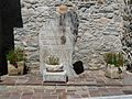
- Fountain
- Fallen memorial
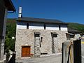
Saint Barthélemy Church

Fountain at the church
Fallen memorial

Community festival hall


Economy and Infrastructure

The former agricultural village of Ignaux now lives mainly from tourism in the form of holiday home rentals (the Ax-3 Domaines winter sports area is only a few kilometers away; the Refuge du Chioula refuge in the far northeast of the municipality is available for mountain hikers ). There are four farms in Ignaux (mainly sheep and goat farming).
Ignaux is away from major traffic axes. In the health resort of Ax-les-Thermes , five (road) kilometers away, there is a connection to the Route nationale 20 ( E 9 ) from Tarascon-sur-Ariège to Puigcerdà in Catalonia. Ax-les-Thermes train station is on the Portet-Saint-Simon- Puigcerdà railway line .