
Urs (Ariège)
| Urs | ||
|---|---|---|
|
||
| region | Occitania | |
| Department | Ariège | |
| Arrondissement | Foix | |
| Canton | Haute-Ariège | |
| Community association | Haute-Ariège | |
| Coordinates | 42 ° 47 ' N , 1 ° 44' E | |
| height | 567-1,160 m | |
| surface | 0.91 km 2 | |
| Residents | 33 (January 1, 2017) | |
| Population density | 36 inhabitants / km 2 | |
| Post Code | 09310 | |
| INSEE code | 09320 | |
.jpg) View from the Ariège bridge to Urs in 1898 |
||

Urs is a French commune with 33 inhabitants (as of January 1, 2017) in the Ariège department in the Occitanie region (until 2015 Midi-Pyrénées ). It belongs to the Arrondissement Foix and the Haute-Ariège community association founded in 2015 . The residents are called Urséens .
geography
The municipality of Urs is located in the Pyrenees , 33 kilometers south-southeast of Foix and about 16 kilometers north of the border with Andorra . With 0.91 km², the third smallest municipality in the Ariège department is bordered in the south by the upper reaches of the Ariège . The village of Urs lies in the floodplain at around 580 m above sea level. North of the village rises a partly wooded, imposing low mountain range with peaks of over 1000 m above sea level like the Pic d'Ecourail at 1135 m . The highest point in the municipality is reached in the extreme northwestern tip ( 1160 m ).
Urs borders on the neighboring communities of Appy in the north, Axiat in the northeast, Lordat in the east, Garanou in the southeast, Lassur in the south and Vèbre in the west.
Population development
| year | 1962 | 1968 | 1975 | 1982 | 1990 | 1999 | 2007 | 2016 |
| Residents | 65 | 39 | 36 | 33 | 30th | 24 | 40 | 34 |
| Sources: Cassini and INSEE | ||||||||
Attractions
- Church of Saint-Pierre et Saint-Paul ( St. Peter and Paul ), monument historique since 1965
- Castel Bieil , ruins of a 12th century castle
- 17th century castle, former residence of the Marquis de Gudanes
- Fallen memorial
- Church of St. Peter and Paul

in summer

in the autumn
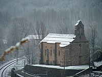
in the winter


Economy and Infrastructure
The formerly agricultural village of Urs now lives mainly from tourism in the form of holiday home rentals (the Ax-3 Domaines winter sports area is only a few kilometers away). There is only one farm left in Urs (greenhouses).
Immediately south of Urs on the left side of the Ariège , the RN 20 / E 9 runs from Tarascon-sur-Ariège to Puigcerdà in Catalonia. The Luzenac - Garanou train station, two kilometers away, is on the railway line from Portet-Saint-Simon to Puigcerdà.
supporting documents
- ↑ Urs on cassini.ehess.fr
- ↑ Urs on insee.fr
- ^ Church of Saint-Pierre et Saint-Paul in the Base Mérimée of the French Ministry of Culture (French)
- ↑ Description et plan du château d'Urs: "Monographies villageoises en Sabarthès", Florence Guillot, 1999
- ↑ Farm on annuaire-mairie.fr (French)