
Rabat-les-Trois-Seigneurs
| Rabat-les-Trois-Seigneurs | ||
|---|---|---|
|
||
| region | Occitania | |
| Department | Ariège | |
| Arrondissement | Foix | |
| Canton | Sabarthès | |
| Community association | Pays de Tarascon | |
| Coordinates | 42 ° 51 ′ N , 1 ° 33 ′ E | |
| height | 548–2,199 m | |
| surface | 26.96 km 2 | |
| Residents | 356 (January 1, 2017) | |
| Population density | 13 inhabitants / km 2 | |
| Post Code | 09400 | |
| INSEE code | 09241 | |
 Place view |
||

Rabat-les-Trois-Seigneurs is a French commune with 356 inhabitants (as of January 1, 2017) in the Ariège department in the Occitanie region ( Midi-Pyrénées until 2015 ). It belongs to the Arrondissement Foix and the municipality association Pays de Tarascon founded in 1994 . The inhabitants are called Rabatols .
geography
The municipality of Rabat-les-Trois-Seigneurs is located in the Pyrenees , 16 kilometers south-southwest of Foix and about 23 kilometers north of the border with Andorra . The almost 27 km² municipal area in the Pyrénées Ariégeoises Regional Nature Park covers part of the catchment area of the left Ariège tributary, the Courbière . From the village of Rabat, 590 m above sea level, in the northeast, the municipal area extends eight kilometers to the west and includes a high mountain backdrop with several mountain lakes and peaks over 2000 m. The highest point is the Pic des Trois-Seigneurs ( 2199 m ), which gives the municipality its name .
Other striking mountain peaks:
|
|


In the shadow of the 2165 m high Pic de Peyroutet, the mountain lakes Étang Bleu, Étang des Rives, Étang du Tirou and Étang Long lie at the tree line at over 1700 m .
- The four mountain lakes
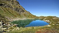
Étang Bleu 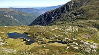
Étang des Rives 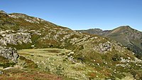
Étang du Tirou 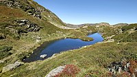
Etang Long


Rabat-les-Trois-Seigneurs borders on the neighboring communities of Saurat in the north, Bédeilhac-et-Aynat and Surba in the north-east, Tarascon-sur-Ariège in the east, Génat in the south-east, Gourbit in the south, Val-de-Sos in the south-west, Le Port in the west and Massat in the northwest.
Population development
| year | 1962 | 1968 | 1975 | 1982 | 1990 | 1999 | 2006 | 2016 |
| Residents | 308 | 260 | 287 | 311 | 298 | 264 | 281 | 351 |
| Sources: annuaire-mairie and INSEE | ||||||||
Attractions
- Notre-Dame-de-l'Assomption ( Assumption ) with origins from the 10th century with rich interiors that as historique monument is designated
- Chapelle du couvent des Filles de la Charité de Saint-Vincent-de-Paul ( Chapel of the Convent of the Daughters of Charity of St. Vincent de Paul )
- Ruins of Miramont Castle, destroyed in 1247
- Waterfall Cascade du Ressec

Notre-Dame-de-l'Assomption church 
Altar of the Notre-Dame-de-l'Assomption church

Miramont Castle ruins 
Waterfall Cascade du Ressec
.jpg)


Economy and Infrastructure
Ten farms are located in Rabat-les-Trois-Seigneurs (sheep, goat and cattle breeding, feed cultivation, beekeeping).
Four kilometers east of Rabat-les-Trois-Seigneurs, Route nationale 20 ( E 9 ) runs from Tarascon-sur-Ariège to Puigcerdà in Catalonia; parallel to this, the railway line from Portet-Saint-Simon to Puigcerdà.
supporting documents
- ↑ Rabat-les-Trois-Seigneurs on annuaire-mairie.fr
- ↑ Rabat-les-Trois-Seigneurs on insee.fr
- ^ Entry in the Base Mérimée of the Ministry of Culture. Retrieved March 20, 2019 (French).
- ↑ Farms on annuaire-mairie.fr (French)