Loubens (Ariège)
|
Louben's praise |
||
|---|---|---|
|
|
||
| region | Occitania | |
| Department | Ariège | |
| Arrondissement | Foix | |
| Canton | Val d'Ariège | |
| Community association | Pays Foix-Varilhes | |
| Coordinates | 43 ° 3 ' N , 1 ° 33' E | |
| height | 382-702 m | |
| surface | 11.73 km 2 | |
| Residents | 274 (January 1, 2017) | |
| Population density | 23 inhabitants / km 2 | |
| Post Code | 09000 | |
| INSEE code | 09173 | |
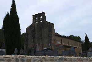
 Sainte-Trinité village church |
||
Loubens ( Occitan : Lobens ) is a French commune with 274 inhabitants (as of January 1, 2017) in the Ariège department in the Occitanie region ; it belongs to the Arrondissement Foix , the municipality association Pays Foix-Varilhes and the canton Val d'Ariège (until 2015: canton Varilhes ). The inhabitants are called Loubénois / Loubénoises .
geography
Loubens is around 63 kilometers south of the city of Toulouse in the north of the Ariège department, southwest of the small town of Pamiers . The community consists of the village of Loubens, several hamlets and scattered settlements as well as individual farms. The municipality is located within the Pyrénées Ariégeoises Regional Nature Park . Loubens is also located in the Massif du Plantaurel in the Pre-Pyrenees (French: Piémont pyrénéen ). The highest point in the municipality is the Pech de Limouzy . Large parts of the community are forested. The D919 is the most important road in the municipality in terms of traffic. The N20 from Paris to Spain passes a few kilometers east of the municipality.
Loubens is surrounded by the neighboring communities of Artix in the north, Rieux-de-Pelleport in the northeast, Crampagna in the east, Baulou in the south and Cazaux in the west.
history
The first human traces from the Stone Age can be found in a cave at Pas du Portel. One of the owners of the parish took part in the First Crusade. In the Middle Ages, the place was within the county of Foix , which was a crown domain of the King of France from 1607 until the French Revolution . The community belonged to the Mirepoix-Pamiers district from 1793 to 1801. In addition, Loubens was from 1793 to 1984 within the canton of Foix and from 1984 to 2015 within the canton of Varilhes . The parish was from 1801 to 1926 and has been reassigned to the Arrondissement of Pamiers since 1942. Between 1926 and 1942 it was part of the Foix arrondissement.
Population development
| year | 1793 | 1800 | 1841 | 1872 | 1911 | 1921 | 1946 | 1954 | 1962 | 1968 | 1975 | 1982 | 1990 | 1999 | 2006 | 2014 |
| Residents | 348 | 278 | 534 | 531 | 393 | 321 | 282 | 212 | 202 | 189 | 150 | 151 | 183 | 200 | 242 | 261 |
| Sources: Cassini and INSEE | ||||||||||||||||
Attractions
- Church Sainte Trinite from the 12th century, since 1964 a monument historique
- Castle Château de Loubens from the 16th century, restored in the 1980s
- Cave Grotte du Portel (not open to the public), since 1969 a historique Monument
- Memorial to the Fallen
- More Attractions
Web links
- Information about Loubens at cassini.ehess.fr
- Location of the place in France
- Loubens on the IGN side
- Photos of the Sainte-Trinité church
- Portrait and landmarks of the community
