
Chameyrat
| Chameyrat | ||
|---|---|---|
.svg)
|
|
|
| region | Nouvelle-Aquitaine | |
| Department | Corrèze | |
| Arrondissement | Grommet | |
| Canton | Naves | |
| Community association | Tulle agglo | |
| Coordinates | 45 ° 14 ′ N , 1 ° 42 ′ E | |
| height | 160-471 m | |
| surface | 18.95 km 2 | |
| Residents | 1,535 (January 1, 2017) | |
| Population density | 81 inhabitants / km 2 | |
| Post Code | 19330 | |
| INSEE code | 19038 | |
 Mairie Chameyrat |
||

Chameyrat is a French commune with 1,535 inhabitants (at January 1, 2017) in the Correze in the region Nouvelle-Aquitaine . The community is a member of the community association Tulle Agglo .
geography
The municipality is located in the Massif Central about ten kilometers southwest of Tulle , the prefecture of the department .
Neighboring municipalities are Naves in the north, Tulle in the north-east, Sainte-Fortunade in the east, Cornil in the south, Saint-Hilaire-Peyroux in the south-west, Favars in the west and Saint-Mexant in the north-west .
coat of arms
Blazon : In blue a golden rooster standing on a silver bell accompanied by three (2; 1) five-pointed golden stars .
Population development
| year | 1962 | 1968 | 1975 | 1982 | 1990 | 1999 | 2007 | 2016 |
| Residents | 1137 | 1185 | 1196 | 1436 | 1569 | 1540 | 1584 | 1552 |
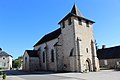
Saint-Etienne church

Fallen memorial

School and former mairie


Personalities
- Louis-Joseph Hugo (1777-1853), French general and uncle Victor Hugos lived in Chameyrat from 1830
Web links
Commons : Chameyrat - collection of images, videos and audio files