Pandrignes
| Pandrignes | ||
|---|---|---|

|
|
|
| region | Nouvelle-Aquitaine | |
| Department | Corrèze | |
| Arrondissement | Grommet | |
| Canton | Sainte-Fortunade | |
| Community association | Tulle agglo | |
| Coordinates | 45 ° 14 ′ N , 1 ° 52 ′ E | |
| height | 314-561 m | |
| surface | 8.45 km 2 | |
| Residents | 166 (January 1, 2017) | |
| Population density | 20 inhabitants / km 2 | |
| Post Code | 19150 | |
| INSEE code | 19158 | |
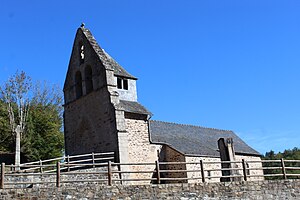
 Saint-Pardoux church |
||
Pandrignes is a French municipality with 166 inhabitants (at January 1, 2017) in the Correze in the region Nouvelle-Aquitaine . The community is a member of the community association Tulle Agglo . The inhabitants call themselves Pandrignois (es).
geography
The municipality is located in the Massif Central about 14 kilometers southeast of Tulle , the prefecture of the department.
Neighboring communities
Neighboring communities are Espagnac in the east, Saint Paul in the south - east , Lagarde-Marc-la-Tour with Marc-la-Tour in the south-west and Ladignac-sur-Rondelles in the west .
Municipal coat of arms
Description : In blue a golden bar and above it a five-pointed silver star .
Population development
| year | 1962 | 1968 | 1975 | 1982 | 1990 | 1999 | 2007 | 2016 |
| Residents | 159 | 181 | 152 | 126 | 139 | 155 | 170 | 164 |
Web links
Commons : Pandrignes - collection of images, videos and audio files
