Saint Salvadour
|
Saint-Salvadour Sent Sauvador |
||
|---|---|---|

|
|
|
| region | Nouvelle-Aquitaine | |
| Department | Corrèze | |
| Arrondissement | Grommet | |
| Canton | Seilhac-Monédières | |
| Community association | Tulle agglo | |
| Coordinates | 45 ° 24 ' N , 1 ° 46' E | |
| height | 305-528 m | |
| surface | 19.47 km 2 | |
| Residents | 300 (January 1, 2017) | |
| Population density | 15 inhabitants / km 2 | |
| Post Code | 19700 | |
| INSEE code | 19240 | |
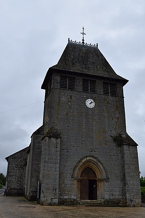
 Saint-Sauveur Church, Monument historique |
||
Saint-Salvadour ( Sent Sauvador in Occitan ) is a French commune of 300 inhabitants (at January 1, 2017) in the Correze in the region Nouvelle-Aquitaine . The community is a member of the community association Tulle Agglo .
geography
The community is located in the Massif Central . Tulle , the prefecture of the department, is about 15 kilometers south.
Neighboring municipalities of Saint-Salvadour are Beaumont in the northeast, Orliac-de-Bar in the east, Bar in the south, Seilhac in the southwest and Chamboulive in the northwest. The river Vimbelle runs along the eastern border of the municipality .
coat of arms
Description : In red a golden tin tower and in the right golden upper corner two running red lions one above the other.
Population development
| year | 1962 | 1968 | 1975 | 1982 | 1990 | 1999 | 2007 | 2016 |
| Residents | 374 | 442 | 356 | 344 | 292 | 295 | 291 | 310 |
Web links
Commons : Saint-Salvadour - Collection of images, videos and audio files
