Ladignac-sur-Rondelles
| Ladignac-sur-Rondelles | ||
|---|---|---|

|
|
|
| region | Nouvelle-Aquitaine | |
| Department | Corrèze | |
| Arrondissement | Grommet | |
| Canton | Sainte-Fortunade | |
| Community association | Tulle agglo | |
| Coordinates | 45 ° 14 ′ N , 1 ° 50 ′ E | |
| height | 273-470 m | |
| surface | 10.18 km 2 | |
| Residents | 406 (January 1, 2017) | |
| Population density | 40 inhabitants / km 2 | |
| Post Code | 19150 | |
| INSEE code | 19096 | |
 Mairie Ladignac |
||
Ladignac-sur-Rondelles is a French municipality with 406 inhabitants (at January 1, 2017), situated in the Correze in the region Nouvelle-Aquitaine . The community is a member of the community association Tulle Agglo .
geography
The community is located in the Massif Central , about ten kilometers south-east of Tulle , the prefecture of the department .
Neighboring municipalities of Ladignac-sur-Rondelles are
- Laguenne-sur-Avalouze with Laguenne in the west and Saint-Bonnet-Avalouze in the north,
- Espagnac in the northeast,
- Pandrignes in the east,
- Lagarde-Marc-la-Tour with Marc-la-Tour in the southeast and Lagarde-Enval in the south,
- Sainte-Fortunade in the southwest.
coat of arms
Description : In blue there is a pressed golden rafter above the three golden sheaves placed in bars . Under the rafters a running red armored golden lion .
Population development
| year | 1962 | 1968 | 1975 | 1982 | 1990 | 1999 | 2007 | 2016 |
| Residents | 296 | 304 | 292 | 345 | 408 | 409 | 441 | 412 |
Attractions
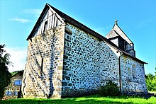
- Church of the Finding of the Relics of St. Stephen ( Église de l'Invention-des-Reliques-de-Saint-Étienne )
Web links
Commons : Ladignac-sur-Rondelles - Collection of images, videos and audio files

