Saint-Pardoux-la-Croisille
| Saint-Pardoux-la-Croisille | ||
|---|---|---|

|
|
|
| region | Nouvelle-Aquitaine | |
| Department | Corrèze | |
| Arrondissement | Grommet | |
| Canton | Sainte-Fortunade | |
| Community association | Tulle agglo | |
| Coordinates | 45 ° 15 ′ N , 1 ° 59 ′ E | |
| height | 424-564 m | |
| surface | 16.36 km 2 | |
| Residents | 177 (January 1, 2017) | |
| Population density | 11 inhabitants / km 2 | |
| Post Code | 19320 | |
| INSEE code | 19231 | |
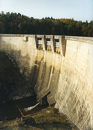
 Barrage de la Valette dam |
||
Saint-Pardoux-la-Croisille is a French municipality with 177 inhabitants (at January 1, 2017) in the Correze in the region Nouvelle-Aquitaine . The inhabitants call themselves Saint-Pardousien (ne) s.
geography
The municipality is located in the Massif Central not far from the Doustre and the dam of la Valette and is surrounded by extensive forests. Tulle , the prefecture of the department, is about 23 kilometers to the west and Égletons 22 kilometers to the northeast.
Neighboring municipalities of Saint-Pardoux-la-Croisille are Clergoux in the north, Champagnac-la-Noaille in the northeast, Marcillac-la-Croisille in the east, Gros-Chastang in the southeast, Gumond in the south and Espagnac in the northwest.
coat of arms
Description : Three golden diagonal bars in red .
Population development
| year | 1962 | 1968 | 1975 | 1982 | 1990 | 1999 | 2007 | 2016 |
| Residents | 206 | 240 | 176 | 168 | 173 | 156 | 169 | 176 |
Attractions
- Barrage de la Valette , a reservoir of the Doustre , used as a hydroelectric power station by the Électricité de France .
