Jumla
| जुम्ला जिल्ला Jumla District
|
|
|---|---|
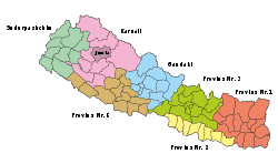
 Location of the Jumla District (darker purple) in the Karnali Province and in Nepal |
|
| Basic data | |
| Country | Nepal |
| province | Karnali |
| Seat | Jumla ( Chandannath ) |
| surface | 2531 km² |
| Residents | 108,921 (2011 census) |
| density | 43 inhabitants per km² |
| ISO 3166-2 | NP-P6 |
| Website | ddcjumla.gov.np |
Coordinates: 29 ° 17 ' N , 82 ° 11' E
The Jumla District ( Nepali जुम्ला जिल्ला Jumlā Jillā ) is one of 77 districts in Nepal and has belonged to the Karnali Province since the 2015 constitution .
history
Until 2015, Jumla was in the Karnali administrative zone .
geography
The Tila River , a right tributary of the Karnali , flows through the district in a west-southwest direction. The district administration is located in Jumla , the capital of the city of Chandannath .
In the Dsitrikt Jumla rice is grown from an altitude of 2,400 to 3,050 m. This is the highest rice-growing area in Nepal. The cultivated Jumli Marsi variety is particularly cold-tolerant and has probably been grown in Jumla on the banks of the Tila River for 1300 years . Both the Tila Valley and the Sinja Khola Valley are covered with rice fields where this type of rice grows, a unique red rice that is coveted for its special taste.
Residents
The district had 89,427 inhabitants in 2001; In 2011 there were 108,921.
Administrative division
The only city ( municipality ) in the district is Chandannath .
Gaunpalikas (rural communities):
By 2017, the district was divided into the following Village Development Committees (VDCs):
Climate table
|
Average monthly temperatures and precipitation for Jumla (Jumla)
Source: [1] (PDF; 191 kB)
|
||||||||||||||||||||||||||||||||||||||||||||||||||||||||||||||||||||||||||||||||||||||||||
Web links
Individual evidence
- ↑ Schedule-4 States, and Districts to be included in the concerned States. - Nepal Law Commission. Retrieved December 13, 2018 .
- ↑ जुम्ला जि.स.स (Brief Introduction). Accessed January 2, 2019 .
- ↑ Central Bureau of Statistics, Census 2011: National Report (pp. 51–52, Population Total and Area in Sq. Km ). ( Memento from May 25, 2013 in the Internet Archive ) (PDF; 7.8 MB)
- ↑ a b Nepal: Administrative Unit - State 6 Map | UN Nepal Information Platform. Retrieved January 1, 2019 .