
Moësa (river)
| Moesa | ||
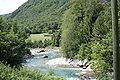
 Moesa at Cama GR |
||
| Data | ||
| Water code | CH : 59 | |
| location | Switzerland | |
| River system | Po | |
| Drain over | Ticino → Po → Mediterranean | |
| source | above the San Bernardino Pass 46 ° 29 ′ 53 ″ N , 9 ° 9 ′ 48 ″ E |
|
| Source height | approx. 2250 m above sea level M. | |
| muzzle | near Arbedo-Castione in Ticino coordinates: 46 ° 13 ′ 9 ″ N , 9 ° 2 ′ 20 ″ E ; CH1903: 723 466 / 119898 46 ° 13 '9 " N , 9 ° 2' 20" O |
|
| Mouth height | 233 m above sea level M. | |
| Height difference | approx. 2017 m | |
| Bottom slope | approx. 44 ‰ | |
| length | 46 km | |
| Catchment area | 474.87 km² | |
| Discharge at the Lumino Sassello A Eo gauge : 472 km² Location: 1.4 km above the mouth |
NNQ (2006) MNQ 1981–2016 MQ 1981–2016 Mq 1981–2016 MHQ 1981–2016 HHQ (1983) |
1.21 m³ / s 9.49 m³ / s 20.4 m³ / s 43.2 l / (s km²) 29.1 m³ / s 567 m³ / s |
| Left tributaries | Traversagna , Montogna , Ri de Fontanalba | |
| Right tributaries | Calancasca | |
| Reservoirs flowed through | Lake Isola | |
| Communities | Mesocco , Soazza , Lostallo , Roveredo GR | |

| ||
Source and mouth of the Moësa
|
The Moësa is a 46 km long left tributary of the Ticino in the cantons of Graubünden and Ticino .
It rises at the San Bernardino Pass at Laghetto Moesola above the village of San Bernardino , where it joins the Ri de Fontanalba , which flows down from the Val Vignun . To the south of the village, the Moësa flows through the Lago d'Isola reservoir , then the remaining water flows through the Misox towards Roveredo , where the Calancasca and Traversagna flow into. For a large part of this section, the A13 motorway runs along the Moësa.
In Arbedo-Castione in Ticino the Moësa flows into the Ticino. The Moësa is popular for kayaking tours .
In its upper reaches, above the village of San Bernardino, the Moësa was spanned between approx. 1820 and 1869 by the 30 meter high Vittorio Emanuele bridge.

Outflow of the Moësa from the Laghetto Moesola

Moesa below the San Bernardino Pass

Waterfall above San Bernardino
at Norantola

at Roveredo GR


Web links
- Moësa (river) on ethorama.library.ethz.ch/de/node
Individual evidence
- ↑ a b Geoserver of the Swiss Federal Administration ( information )
- ↑ Evaluations of the water network. (XLSX) (No longer available online.) FOEN , December 2013, archived from the original on June 13, 2018 ; Retrieved on August 9, 2017 (listing of Swiss rivers> 30km). Info: The archive link was inserted automatically and has not yet been checked. Please check the original and archive link according to the instructions and then remove this notice.
- ↑ Modeled mean annual discharge. In: Topographical catchment areas of Swiss waters: sub-catchment areas 2 km². Retrieved August 30, 2017 .
- ↑ Sassello Lumino measuring station 1981–2016 (PDF) Federal Office for the Environment FOEN
- ↑ EGL / Misoxer power plants have to let more residual water flow. In: swissinfo.ch . November 26, 2009, accessed March 2, 2020 .
Rivers with a total length of more than 30 km:
Aare |
Albula |
Allaine |
Old Rhine |
Arbogne |
Areuse |
Swiss stone pine |
Birs |
Brenno |
Broye |
Calancasca |
Doubs |
Drance de Bagnes |
Thinning |
Emme |
Engelberger Aa |
Ergolz |
Glâne |
Smooth |
Glenner (Glogn) |
Hinterrhein |
Inn (En) |
Julia (Gelgia) |
Kander |
Little Emme |
Landquart |
Land water |
Langete |
Limmat |
Linth |
Lorze |
Maggia |
Mentue |
Moësa |
Muota |
Murg |
Necker |
Orbe |
Petite Glâne |
Plessur |
Rabiusa |
Reuss |
Rhine |
Rhone |
Saane |
Schüss (Suze) |
Seez |
Scythe |
Sihl |
Simme |
Sitter |
Sorne |
Suhre |
Talent |
Tamina |
Ticino (Ticino) |
Thur |
Töss |
Venoge |
Verzasca |
Vispa |
Vorderrhein |
Wigger |
Wyna