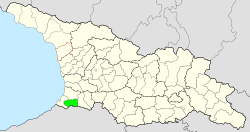
Keda Municipality
| Keda Municipality | |||
|---|---|---|---|
 |
|||
| Symbols | |||
|
|||
| Basic data | |||
| Country | Georgia | ||
| Autonomous Republic | Adjara | ||
| Seat | Keda | ||
| surface | 452 km² | ||
| Residents | 16,760 (2014) | ||
| density | 37 inhabitants per km² | ||
| ISO 3166-2 | GE-AJ | ||
| Website | keda.ge (Georgian) | ||
| Saint George's Chapel | |||
Coordinates: 41 ° 34 ' N , 41 ° 57' E
The municipality of Keda ( Georgian ქედის მუნიციპალიტეტი , Kedis munizipaliteti ) is an administrative unit (roughly equivalent to a district ) in the Autonomous Republic of Adjara in Georgia .
geography
The administrative center of the municipality of Keda is the minor city of Keda . The area is 452 km². At 16,760 inhabitants (2014), the number of inhabitants has fallen sharply compared to the previous census (20,024 inhabitants in 2002).
- Population development

Note: census data
Keda Municipality is bounded in the north by Kobuleti Municipality , in the west by Chelwachauri Municipality , in the east by Shuachewi Municipality and in the south by Turkey . The border between the municipality of Keda and Turkey runs on the ridge of the Shavshet Mountains . This is also where the municipality's highest mountain is located, the Ghoma at 2,441 meters above sea level. The Mescheti Mountains begin in the northeast part of the area .
The largest river is the Ajariszqali . The Ajariszqali Valley in Keda Municipality is one of the most forested areas in Georgia. The subtropical flora and fauna there are not found in other regions of the country.
The largest towns besides Keda (1510 inhabitants) are Acho , Charaula , Kokotauri , Pirweli Maissi (" May 1st ") and Zchmorissi (2014), each with over 500 inhabitants . The municipality is divided into the independent capital Keda and ten municipalities (Georgian temi, თემი ) with a total of 64 localities:
| local community | Number of towns |
Population (2014) |
|---|---|---|
| Dandalo | 7th | 1961 |
| Dologani | 3 | 781 |
| Keda | 11 | 1988 |
| Machunzeti | 9 | 2121 |
| Merissi | 7th | 1132 |
| Oktomberi | 5 | 853 |
| Pirweli Maissi | 4th | 1213 |
| Sware | 5 | 1346 |
| Zchmorissi | 6th | 2605 |
| Zoniarissi | 7 1 | 1250 |
Attractions
In some villages of the municipality there are ruins of medieval fortresses. Some medieval bridges have also been preserved.
Web links
- Website of the municipality of Keda (Georgian, partly English and Russian)
Individual evidence
- ↑ a b c Population Census 2014 ( Memento of the original from September 20, 2016 in the Internet Archive ) Info: The archive link was inserted automatically and has not yet been checked. Please check the original and archive link according to the instructions and then remove this notice. (English)
- ↑ Population Census 2002 ( Memento of the original from September 24, 2015 in the Internet Archive ) Info: The archive link was inserted automatically and has not yet been checked. Please check the original and archive link according to the instructions and then remove this notice. (English)


