
Lanchuti Municipality
| Lanchuti Municipality | |||
|---|---|---|---|
 |
|||
| Symbols | |||
|
|||
| Basic data | |||
| Country | Georgia | ||
| region | Guria | ||
| Seat | Lanchuti | ||
| surface | 533 km² | ||
| Residents | 31,486 (2014) | ||
| density | 59 inhabitants per km² | ||
| ISO 3166-2 | GE-GU | ||
| Website | www.lanchkhuti.org.ge (Georgian) | ||


Coordinates: 41 ° 54 ' N , 42 ° 24' E
The Lantschchuti municipality ( Georgian ლანჩხუთის მუნიციპალიტეტი , Lantschchutis munizipaliteti ) is an administrative unit (roughly equivalent to a district ) in the Guria region in western Georgia .
geography
The administrative center of the 533.1 km² municipality is the eponymous town of Lantschchuti .
In the south and southeast of the municipality lanchkhuti from the Gurian municipalities will ozurgeti and chokhatauri , in the east of the municipality Samtredia in the region Imereti and in the north - east to west - from the municipalities Abascha , Senaki and Chobi and the territory of the region imputed city Poti limited in the Mingrelia and Upper Svaneti region . In the west the municipality borders on the Black Sea .
The northern half of the territory of the municipality is occupied by the Colchian Plain , which rises from the sea coast to the far east of the area to only 15 m above sea level. There are no localities in this area: in particular the northwestern part is occupied by forests and swamps, which are largely protected as part of the Colchis National Park; the rest is used intensively for agriculture. The southern part of the municipality is characterized by low, wooded mountainous terrain, which rises to almost 700 m in the southeast with the Sairao ridge . Most of the larger towns along the edge of the plain.
The lower course of the Supsa River runs through the southwest of the municipality to its mouth in the Black Sea. In the east, the most important west Georgian river Rioni is reached on a short section , which otherwise flows a little north across the municipal border. In the north-west, the border runs along the east bank of the lagoon-like Paliastomi Lake .
Population and administrative division
With 31,486 inhabitants (2014), the population has decreased by almost a quarter compared to the previous census (40,507 inhabitants in 2002). Before that, the number of inhabitants had been virtually stable since at least the 1930s.
- Population development
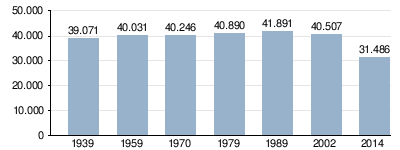
Note: census data
The population is almost mono-ethnic Georgian (about 98.4%); there are also a small number of predominantly Russians and Armenians (as of 2002).
The largest villages besides the city of Lanchchuti (6395 inhabitants) are the villages of Chadschalia , Kvemo Shuchuti , Lessa , Nigwsiani and Zqalzminda (2014), each with over 1000 inhabitants .
The municipality is divided into the independent capital Lantschchuti and 15 municipalities (Georgian temi, თემი ) with a total of 55 localities:
| local community | Number of towns |
Population (2014) |
|---|---|---|
| Aketi | 4th | 1534 |
| Azana | 2 | 790 |
| Juruqweti | 3 | 1450 |
| Ghrmaghele | 4th | 2818 |
| Gwimbalauri | 2 | 1097 |
| Lessa-Tschinati | 2 | 1437 |
| Mamati | 4th | 830 |
| Machchwareti | 3 | 714 |
| Nigoiti | 6th | 2510 |
| Nigwsiani | 4th | 2570 |
| Ninoshvili | 2 | 567 |
| Shuchuti | 2 | 1607 |
| Supsa | 7th | 3250 |
| Tschibati | 3 | 1503 |
| Chochchati | 7th | 2414 |
history
From the collapse of the Kingdom of Georgia in the early 15th century until the 19th century, the territory of today's municipality belonged to the Principality of Guria. After the annexation to the Russian Empire it became part of the Ujesds Gurien. This existed with different administrative assignments until the Soviet period, in the 1920s as Okrug Osurgeti. In 1930 the independent Lanchchuti Rajon was spun off. After the independence of Georgia in 1995 it was attached to the newly formed Guria region and in 2006 it was converted into a municipality.
traffic
The international trunk road S12 ( ს 12 ) coming from Samtredia runs through the municipality in an east-west direction , also European route 692. Near the Black Sea coast it joins the trunk road S2 ( ს 2 ) coming from Senaki via Poti , on this section also part of the European route 70 , and is thus part of the shortest connection between central Georgia and the second largest city in the country Batumi . A new highway parallel to today's S12 is under construction (as of 2017), which bypasses the large number of places on the road in the area of the municipality of Lanchchuti to the north. In lanchkhuti branches from the S12 national road Sch47 ( შ 47 ) and to the west the Sch82 ( შ 82 ) from passing through the southern mountains to the valley of Supsa - there already in the ozurgeti municipality - or further into the main town, while regional capital ozurgeti lead .
The S12 trunk road is followed by the Samtredia - Batumi railway with stations in the administrative center of Lantschchuti, among others.
Web links
- Website of the Municipality of Lanchuti (Georgian)
Individual evidence
- ↑ a b c Population Census 2014 ( Memento of the original from September 20, 2016 in the Internet Archive ) Info: The archive link was inserted automatically and has not yet been checked. Please check the original and archive link according to the instructions and then remove this notice. (English)
- ↑ Population Census 2002 ( Memento of the original from September 24, 2015 in the Internet Archive ) Info: The archive link was inserted automatically and has not yet been checked. Please check the original and archive link according to the instructions and then remove this notice. (English)
