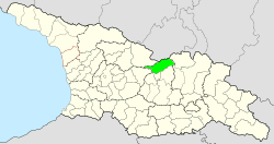
Java Municipality
| Java Municipality | |
|---|---|
 |
|
| Basic data | |
| Country | Georgia |
| region | Inner Cartlia |
| Seat | Java |
| ISO 3166-2 | GE-SK |
Coordinates: 42 ° 24 ' N , 43 ° 54' E
Municipality of Jawa ( Georgian ჯავის მუნიციპალიტეტი , Dschawis munizipaliteti ) is de jure an administrative unit (roughly equivalent to a district ) in the north of the Inner Kartlien region in Georgia .
The administrative center of the municipality is the city of Jawa ( Ossetian Dzau ). Since the Georgian- South Ossetian conflict began in 1992, the territory of the municipality has not been controlled by the Georgian central government, but by the Republic of South Ossetia, which is only recognized by a few states. From their perspective, the territory of the municipality is part of the Rajons dsau , which also includes smaller in the west parts of the municipalities Oni (Region Racha-Lechkhumi and Kvemo Svaneti ) and - since the Caucasus 2008 war - Sachkhere (Region Imereti include).
In 1989 , 10,418 people lived in what was then Dschawa Rajon of the South Ossetian Autonomous Region , the extent of which actually corresponded to that of today's Dzau Rajon, i.e. more than the Jawa municipality, 10,418 people, in 2015 according to South Ossetian data there were 6,567.
The municipality of Java is located on the southern flank of the Greater Caucasus , in the valleys of the Great Liachwi , Qwirila and Jedschora rivers . It borders in the north on the Republic of North Ossetia-Alania of the Russian Federation .
Web links
- Official website of the Inner Kartli Region (Georgian)
Individual evidence
- ^ Press conference of the head of the South Ossetian statistical agency . Report from the South Ossetian Res news agency dated August 11, 2016, accessed on April 27, 2017.
