
Wani Municipality
| Wani Municipality | |||
|---|---|---|---|
 |
|||
| Symbols | |||
|
|||
| Basic data | |||
| Country | Georgia | ||
| region | Imereti | ||
| Seat | Wani | ||
| surface | 557 km² | ||
| Residents | 24,512 (2014) | ||
| density | 44 inhabitants per km² | ||
| ISO 3166-2 | GE-IM | ||
| Website | vani.gov.ge (Georgian) | ||


Coordinates: 42 ° 0 ' N , 42 ° 36' E
The municipality of Wani ( Georgian ვანის მუნიციპალიტეტი , Wanis munizipaliteti ) is an administrative unit (roughly equivalent to a district ) in the Imereti region in the western central part of Georgia .
geography
The administrative center of the municipality is the eponymous small town of Wani . The 557 km² municipality borders in the northwest on the municipality Samtredia , in the north on the municipality Zqaltubo and in the east on the municipality Baghdati , all also in Imereti. In the southwest it is bounded by the municipality of Chochatauri in the Guria region and in the south on a short section by the municipality of Adigeni in the Samtskhe-Javakheti region .
The extreme north of the municipality is located in the southeastern part of the Colchian Plain , in this area also known as the Imeretian Plain and rising in an easterly direction from around 25 m to around 100 m above sea level. The northern border of the municipality is marked by the Rioni flowing through the plain . South of the plain, the terrain rises rapidly to over 1000 m , and then gradually to the main ridge of the Meschetian Mountains , which form the southern border of the municipality and where it reaches its greatest height with the 2850 m high summit of Mepiszqaro. From there a reforested, over 2000 m high secondary ridge extends north along the southwest border of the municipality. The left-hand Chaniszqali tributary, Zablariszqali, flows along part of the southeastern border . Almost all localities are located in the area of the lowlands at the foot of the mountainous region and its outskirts, as well as in the lower valley sections of the short left Rioni tributaries there, such as the Sulori .
Population and administrative division
With 24,512 inhabitants (2014), the population has decreased by more than a quarter compared to the previous census (34,464 inhabitants in 2002), well above the national average. Before that, the population had been falling almost constantly, albeit more slowly, since at least the 1930s (43,974 inhabitants in 1939).
- Population development
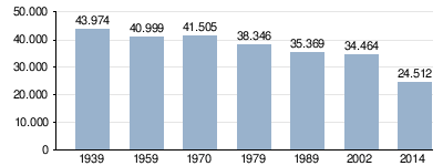
Note: census data
The population is almost mono-ethnic Georgian (99.5%); there is also a small number of mainly Russians (as of 2002).
The largest towns besides the small town of Wani (3744 inhabitants) are the villages of Amaghleba , Dichaschcho , Kweda Bswani , Salchino , Schuamta and Zichessulori (2014), each with over 1000 inhabitants .
The municipality is divided into the independent capital Wani as well as 20 municipalities (Georgian temi, bei or simply "village", Georgian sopeli, სოფელი ) with a total of 41 villages, one of which has no permanent residents:
| local community | Number of towns |
Population (2014) |
|---|---|---|
| Amaghleba | 2 | 1561 |
| Bswani | 2 | 1461 |
| Dichaschcho | 3 | 1757 |
| Dsuluchi | 1 | 418 |
| Gadidi | 2 | 199 |
| Gora | 2 | 1356 |
| Mtisdsiri | 2 | 831 |
| Mukedi | 2 | 580 |
| Pereta | 2 1 | 663 |
| Qumuri | 3 | 641 |
| Salchino | 2 | 1441 |
| Salominao | 2 | 790 |
| Saprassia | 2 | 681 |
| Shuamta | 2 | 1683 |
| Seda Wani | 2 | 1132 |
| Seindari | 2 | 1869 |
| Sulori | 1 | 702 |
| Tobanieri | 4th | 1270 |
| Uchuti | 2 | 598 |
| Zichessulori | 1 | 1135 |
history
From the collapse of the Kingdom of Georgia in the 15th century until the 19th century, the area belonged virtually continuously to the Kingdom of Imereti . While Georgia was part of the Russian Empire and until the early years of the Soviet Union , it was part of the Ujesds Kutais of the Kutais Governorate ( Kutais was the official form of the city name at that time).
In 1930 the Wani district was formed there. After the independence of Georgia in 1995 the Rajon was assigned to the newly created region of Imeretia and in 2006 it was converted into a municipality.
traffic
The most important traffic connection through the north of the municipality with the administrative center is the national road Sch13 ( შ 13 ) from Samtredia to Baghdati . Branch off from this, the short Sch105 ( შ 105 ) and Sch106 ( შ 106 ) open up the towns in the Sulori valley above Wani or the extreme northwest of the area. On the southeast edge of the municipality runs a section of the Sch14 ( შ 14 ), which crosses the Meschetian Mountains on its route from Kutaisi to the municipality of Adigeni. There is no direct connection to the north via the Rioni in the area of the municipality.
The municipality also has no direct rail connection; the closest stations are to the northwest Samtredia and northeast Rioni near Kutaisi, both on the Poti - Tbilisi (- Baku) route .
Web links
- Wani municipality website (Georgian)
Individual evidence
- ↑ a b c Population Census 2014 ( Memento of the original from September 20, 2016 in the Internet Archive ) Info: The archive link was inserted automatically and has not yet been checked. Please check the original and archive link according to the instructions and then remove this notice. (English)
- ↑ Population Census 2002 ( Memento of the original from September 24, 2015 in the Internet Archive ) Info: The archive link was inserted automatically and has not yet been checked. Please check the original and archive link according to the instructions and then remove this notice. (English)
