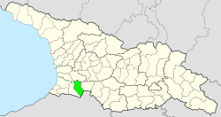
Chulo Municipality
| Chulo Municipality | |||
|---|---|---|---|
 |
|||
| Symbols | |||
|
|||
| Basic data | |||
| Country | Georgia | ||
| Autonomous Republic | Adjara | ||
| Seat | Chulo | ||
| surface | 710 km² | ||
| Residents | 23,327 (2014) | ||
| density | 33 inhabitants per km² | ||
| ISO 3166-2 | GE-AJ | ||
| Website | www.khulo.ge (Georgian) | ||
Coordinates: 41 ° 39 ' N , 42 ° 19' E
Munizipalität Chulo ( Georgian ხულოს მუნიციპალიტეტი , Chulos munizipaliteti ) is an administrative unit (roughly equivalent to a district ) in the Autonomous Republic of Adjara in southwest Georgia .
geography
The administrative center of the municipality of Chulo is the minority town of Chulo . The area of the municipality Ajariens furthest to the east from the coast of the Black Sea is 710 km². At 23,327 inhabitants (2014), the population has fallen sharply compared to the previous census (33,430 inhabitants in 2002).
- Population development

Note: census data. 1952 Shuachewi Rajon outsourced.
In the west, the municipality of Chulo is bounded by the municipality of Shuachewi , in the northwest by the municipality of Osurgeti , in the north by the municipality of Chochatauri , in the east by the municipality of Adigeni and in the south by Turkey .
The territory of the municipality is mountainous: In the south, along the state border with Turkey, the Shavschet Mountains with the 2992 meter high Kentschauli, in the north the Meschetian Mountains, which are 2700 meters high . The largest river is the Ajariszqali .
The largest village is the village of Kwemo Vashlowani , with 1044 inhabitants before the main town of Chulo with 1007 inhabitants; other larger towns, each with over 600 inhabitants, are Dekanaschwilebi , Didatschara , Kedlebi , Riqeti and Zablana (2014). The municipality is divided into the independent capital Chulo and twelve municipalities (Georgian temi, თემი or simply "village", Georgian sopeli, სოფელი ) with a total of 78 localities:
| local community | Number of towns |
Population (2014) |
|---|---|---|
| Agara | 1 | 497 |
| Chichadsiri | 4th | 830 |
| Deanashvilebi | 12 | 4147 |
| Didachara | 3 | 1549 |
| Dioknissi | 11 | 3205 |
| Ghordjomi | 16 | 2813 |
| Pushrukauli | 5 | 836 |
| Riqeti | 4th | 1788 |
| Sazichuri | 4th | 648 |
| Schalti | 8th | 2749 |
| Tchilwana | 4th | 1031 |
| Vashlowani | 6th | 2227 |
Attractions
In the municipality of Chulo there are some sights, such as the Schalta church from the 13th century and the Chichani fortress from the 10th to 13th centuries. In the east of the municipality is the Green Lake (Mzwane Tba).
Web links
- Website of Chulo Municipality (Georgian)
Individual evidence
- ↑ a b c Population Census 2014 ( Memento of the original from September 20, 2016 in the Internet Archive ) Info: The archive link was inserted automatically and has not yet been checked. Please check the original and archive link according to the instructions and then remove this notice. (English)
- ↑ Population Census 2002 ( Memento of the original from September 24, 2015 in the Internet Archive ) Info: The archive link was inserted automatically and has not yet been checked. Please check the original and archive link according to the instructions and then remove this notice. (English)


