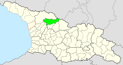
Lentechi municipality
| Lentechi municipality | |||
|---|---|---|---|
 |
|||
| Symbols | |||
|
|||
| Basic data | |||
| Country | Georgia | ||
| region | Ratscha-Letschchumi and Lower Swanetia | ||
| Seat | Lentechi | ||
| surface | 1344 km² | ||
| Residents | 4386 (2014) | ||
| density | 3.3 inhabitants per km² | ||
| ISO 3166-2 | GE-RL | ||
| Website | lentekhi.ge (Georgian) | ||
Coordinates: 42 ° 47 ' N , 42 ° 43' E
The municipality Lentechi ( Georgian ლენტეხის მუნიციპალიტეტი , Lentechis munizipaliteti ) is an administrative unit (roughly equivalent to a district ) in the Ratscha-Letschchumi region and Lower Vanetia in northern Georgia .
geography
The administrative center of the municipality is the minority (Georgian დაბა , daba ) Lentechi . The 1344 km 2 municipality borders on the municipalities of Zageri in the south, on the municipalities of Ambrolauri and Oni in the southeast , all also in the Ratscha-Letschchumi and Lower Vanetia region, in the southeast on the municipalities of Tschchorozqu and Martwili and in the north on the municipalities of Mestia der region Samegrelo-Zemo Svaneti . In the northeast the municipality is bounded by the state border with Russia (Republic of Kabardino-Balkaria ).
The municipality occupies the upper part of the valley of the right Rioni tributary Zcheniszqali and its tributaries. The area forms the southern part of the historical province of Svaneti and is called Lower Svaneti (Georgian Kwemo Svaneti; Upper Svanetia, Georgian Semo Svaneti is today's municipality of Mestia to the north). The entire municipality is located in the high mountains : the main ridge of the Greater Caucasus runs along the border with Russia with the 4547 m high Ailama as the highest peak on this section, from Upper Svaneti in the north the area is up to 4009 m ( Lahili or Laila) high Svanetian mountains separated in the southwest extending there up to 3174 m high Egrissi Mountains the and south to south east Lechkhumi mountains with the 3562 m high Tschutkara (the highest peak of the mountain, of 3584 m high Samerzchle , is close to a there branching off to the southeast side ridge already on the territory of the neighboring municipal Ambrolauri).
Population and administrative division
With 4,386 inhabitants (2014), the population of the remote area has again fallen sharply - by more than half - compared to the previous census (8,991 inhabitants in 2002), after having been continuously decreasing since the 1950s (14,692 inhabitants in 1959).
- Population development

Note: census data
The largest localities besides the minor town Lentechi (947 inhabitants) are the villages Cheledi (258 inhabitants), Rzchmeluri (232) and Sassaschi (182, all 2014).
The municipality is divided into eight municipalities (referred to as the "territorial organ " for the minority, Georgian teritoriuli organo, ტერიტორიული ორგანო , for the villages Georgian temi, თემი ) with a total of 61 localities (five of which have no permanent residents):
| local community | Number of towns |
Population (2014) |
|---|---|---|
| Cheledi | 8th | 511 |
| Chopuri | 5 | 280 |
| Lentechi 1 | 9 | 1523 |
| Rzchmeluri | 5 | 443 |
| Schachunderi | 9 2 | 686 |
| Tschichareschi | 10 2 | 532 |
| Choluri | 12 2 | 406 |
| Zana | 3 3 | 5 |
history
After the disintegration of the Kingdom of Georgia, the area of the municipality formed the principality of Lower Svaneti, roughly in its current borders from the 16th century until the annexation by the Russian Empire in the years 1857 to 1859. As a result, it formed the central part of the Ujesds Letschchumi of the Kutais governorate with its seat in Zageri until the early years of the Soviet Union . In 1930 the area became independent as the Lower Svaneti Rajon (Georgian ქვემო სვანეთის რაიონი , Kwemo Swanetis raioni; Russian Нижне-Сванетский район , Nizhne-Swanetski rajon ). In 1953 it was named Lentechi after its main town. After Georgia gained independence, the Rajon was assigned to the newly formed Ratscha-Letschchumi and Lower Svaneti region in 1995 and converted into a municipality in 2006.
traffic
The municipality's only traffic axis is the national road Sch15 ( შ 15 ), which follows the river Zcheniszqali from Kutaisi via Zqaltubo (there is the closest train station) and Zageri. In the far east of the municipality, the road then runs in the valley of the right tributary Sescho to its tributary Lasdili above the last village in the valley, the Qoruldaschi , which is not permanently inhabited today . The road leading from there over the 2623 m high Sagaro Pass between the Svaneti Mountains and the main Caucasus ridge to Upper Svaneti (municipality of Mestia) is not passable in winter, depending on the snow conditions; However, this section has been upgraded to the eastern end of the national road Sch7 ( შ 7 ) from Zugdidi via Jvari and Mestia .
Web links
- Lentechi Municipality website (Georgian)
Individual evidence
- ↑ a b c Population Census 2014 ( Memento of the original from September 20, 2016 in the Internet Archive ) Info: The archive link was inserted automatically and has not yet been checked. Please check the original and archive link according to the instructions and then remove this notice. (English)
- ↑ Population Census 2002 ( Memento of the original from September 24, 2015 in the Internet Archive ) Info: The archive link was inserted automatically and has not yet been checked. Please check the original and archive link according to the instructions and then remove this notice. (English)


