Mtskheta Municipality
| Mtskheta Municipality | |||
|---|---|---|---|
 |
|||
| Symbols | |||
|
|||
| Basic data | |||
| Country | Georgia | ||
| region | Mtskheta-Mtianeti | ||
| Seat | Mtskheta | ||
| surface | 805 km² | ||
| Residents | 47,711 (2014) | ||
| density | 59 inhabitants per km² | ||
| ISO 3166-2 | GE-MM | ||
| Website | mtskheta.org.ge (Georgian, English) | ||
Coordinates: 41 ° 54 ' N , 44 ° 42' E
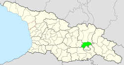
The municipality of Mtskheta ( Georgian მცხეთის მუნიციპალიტეტი , Mzchetis munizipaliteti ) is an administrative unit (roughly equivalent to a district ) in the Mtskheta-Mtianeti region in the eastern central part of Georgia .
geography
The administrative center of the municipality is the small town of Mtskheta . As the administrative center of the region, the city itself has not been part of the municipality since 2014, but is directly subordinate to the region.
The 805 km² municipality borders on the municipality of Dusheti in the north and on the municipality of Tianeti in the northeast , both also in the Mtskheta-Mtianeti region, in the east on the municipality of Sagaredscho in the Kakheti region , in the south on the capital region Tbilisi , in the southeast on the Municipality of Gardabani and in the southwest to the municipality of Tetrizqaro of the Niederkartlien region and to the west to the municipality of Kaspi of the Inner Kartlien region .
The central part of the municipality is located in the valleys of the Kura and the opening out in the city of Mtskheta from left Aragvi . In the northwest, the Kura tributary Ksani, also on the left, marks part of the border with the municipality of Kaspi, in the southwest the right Kura tributary Were marks a section of the border with the urban area of Tbilisi. The south-west of the area is reached by the easternmost foothills of the Trialeti Mountains , which are there up to over 1700 m high. In the south to the south-east of the Kura, the Saguramo Mountains extend to the left of the Kura and reach a height of almost 1800 m at the border of the municipality . Along the north-eastern border, the southernmost part of the Cartelian Mountains does not connect , there it is over 1,600 m high. In the northwest, between Aragwi and Ksani, the mountains rise in two stages from the narrow Kura valley up to 1,300 m .
Most of the Tbilisi National Park is located on the territory of the municipality in the area of the Cartlian and Saguramo Mountains .
Population and administrative division
With 47,711 inhabitants (2014), the population has decreased compared to the previous census (64,829 inhabitants 2002), but only due to the spin-off of the city of Mtskheta in 2014 and the transfer of an area with nine villages to the capital region of Tbilisi in 2007 (the minor city / daba Sahessi and the municipality of Gldani with one place in today's Stadtrajon Gldani , the entire municipality of Dighomi with five places in the Stadtrajon Saburtalo and two places in the municipality of Lissi on the Stadtrajon Wake ).
In relation to the former area of the municipality, in which 72,862 people lived in 2014, the number of inhabitants has even increased significantly against the overall Georgian trend; While it actually fell slightly overall in the ceded area (from 25,998 to 25,151), the increase in the remaining part of the municipality compared to 38,831 inhabitants in 2002 was almost 23%. This is mainly due to the establishment of refugee camps after the Caucasus War in 2008 , for example in the villages of Preseti , Zerowani and Zilkani (Camp Achalubani).
The population had previously risen steadily since the 1950s, but slowed down in the 1990s.
- Population development

Note: census data. 2007 part of the area (with nine places) transferred to Tbilisi , in 2014 the city of Mtskheta spun off: for comparison, the number of inhabitants of the municipality with these places in 2014 is also shown.
The municipality is predominantly inhabited by Georgians (90.71%); 3.45% are Azerbaijanis (mainly in the villages of Mschaldiri , Zichisdsiri and Zodoreti ), 2.26% Ossetians and 1.50% Assyrians (compact in the village of Dsweli Kanda , all as of 2002).
The largest localities besides the minor city of Mtskheta (7940 inhabitants) are the villages of Dzalissi , Dsegwi , Ksani , Missakzieli , Muchrani , Zerowani and Zilkani (2014), each with over 2000 inhabitants .
The municipality is divided into the independent main town of Mtskheta and 16 municipalities (Georgian temi, bei or simply "village", Georgian sopeli, სოფელი ) with a total of 66 villages, four of which have no permanent residents:
| local community | Number of towns |
Population (2014) |
|---|---|---|
| Aghdgomliantkari | 5 | 1779 |
| Dzalissi | 1 | 2104 |
| Dzegwi | 5 | 3078 |
| Galawani | 8 1 | 2633 |
| Ksani | 1 | 2962 |
| Ksowrissi | 2 | 1425 |
| Lissi | 12 3 | 1784 |
| Missakzieli | 4th | 3769 |
| Muchrani | 3 | 7735 |
| Nitschbissi | 4th | 1767 |
| Saguramo | 7th | 2834 |
| Wasiani | 1 | 526 |
| Zchvarichamia | 6th | 259 |
| Zerowani | 4th | 9350 |
| Zichisdsiri | 1 | 1606 |
| Zilkani | 2 | 4100 |
history
After the collapse of the medieval Kingdom of Georgia in the 16th century, the entire area belonged to the independent Kingdom of Kartlien and then to the unified Kartlien- Kakheti in 1762 . While belonging to the Russian Empire it came to the Tbilisi Governorate and was divided between its Ujesden Tiflis, Dusheti and Gori .
This structure continued into the early years of the Soviet Union . In 1928 the short-lived Okrug Tbilisi was formed and in 1930 a Mtskheta district was designated for the first time , which, however, was re-established in the Tbilisi district in 1934. After the spin-off of the city of Tbilisi in 1938, this included the entire area surrounding the Georgian capital as an independent administrative part. The exact time of the renewed formation of the Mtskheta Raion is unknown, probably no later than the mid-1950s. After Georgia gained independence, the Rajon was assigned to the newly formed Mtskheta-Mtianeti region in 1995 and converted into a municipality in 2006.
traffic
The international trunk road S1 ( ს 1 ) runs through the municipality from Tbilisi to the Russian or Abkhazian border, on this section at the same time European route 60 and continuously expanded to a motorway . To the north of Mtskheta, the international trunk road S3 , at the same time European route 117 and following the course of the historic Georgian military road along the Aragwi, branches off in the direction of the Russian border.
The eastern part of the municipality is crossed by the national road Sch30 ( შ 30 ) from Tbilisi to the neighboring administrative center of Tianeti to the northeast , which overcomes the Saburtalo and Kartlische mountains over two 1,100 m and 1,400 m high passes . The Sch29 ( შ 29 ) follows the right Kura bank from Mtskheta upwards towards Gori, the Sch28 ( შ 28 ) follows the left Ksani bank from the S1 towards Akhalgori in the municipality of the same name (or Leningor Rajon of the breakaway republic of South Ossetia ). The Sch 149 ( შ 149 ) opens up the eastern central part of the Mzcheta area through the valley of the left Aragvi tributary Tesami to the Sch30, the Sch 151 ( შ 151 ) the northwest between S3 and Sch28. The localities in the extreme southwest of the area are not connected to the central part of the municipality by road, but can only be reached via Tbilisi. Near the western border of the area, the Sch 153 ( შ 153 ) crosses the Trialeti Mountains from the Sch29 in the direction of the municipality of Tetrizqaro ( Sch36 / შ 36 near Manglissi ) as a western bypass of Tbilisi; but this has so far been an unpaved runway.
The Transcaucasian railway line Poti – Tbilisi – Baku with stations in Ksani, Dzegwi and Mtskheta runs through the Kura Valley on the territory of the municipality .
Web links
- Website of the Municipality of Mtskheta (Georgian, English)
Individual evidence
- ↑ a b c Population Census 2014 ( Memento of the original from September 20, 2016 in the Internet Archive ) Info: The archive link was inserted automatically and has not yet been checked. Please check the original and archive link according to the instructions and then remove this notice. (English)
- ↑ Population Census 2002 ( Memento of the original from September 24, 2015 in the Internet Archive ) Info: The archive link was inserted automatically and has not yet been checked. Please check the original and archive link according to the instructions and then remove this notice. (English)


