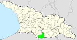
Ninozminda Municipality
| Ninozminda Municipality | |||
|---|---|---|---|
 |
|||
| Symbols | |||
|
|||
| Basic data | |||
| Country | Georgia | ||
| region | Samtskhe Javakheti | ||
| Seat | Ninozminda | ||
| surface | 1354 km² | ||
| Residents | 24,491 (2014) | ||
| density | 18 inhabitants per km² | ||
| ISO 3166-2 | GE-SJ | ||
| Website | ninotsminda.ge (Georgian) | ||
Coordinates: 41 ° 15 ' N , 43 ° 36' E
The municipality Ninozminda ( Georgian ნინოწმინდის მუნიციპალიტეტი , Ninozmindis munizipaliteti ) is an administrative unit (roughly equivalent to a district ) in the Samtskhe-Javakheti region in southern Georgia .
geography
The administrative center of the municipality Ninozminda is the eponymous small town of Ninozminda . The 1,353.9 square kilometers municipality is bordered to the west by the also belongs to the region of Samtskhe-Javakheti municipality Akhalkalaki , on the northeast by the municipality Zalka and the east by the municipality Dmanisi , both in the region Kvemo Kartli . The state border with Turkey runs for a short section in the southwest, and the border with Armenia in the south .
The municipality comprises the eastern part of the Akhalkalaki plateau , also called the Javakheti plateau , at an altitude of 1800 to 2200 m above sea level . In the east it is bordered by the Javakheti Mountains , with the 3157 m high Leili in the extreme southeast of the municipality on the border with Armenia as the highest peak. The Samsara Mountains with the 3188 m high Gudarebi extend into the northwest of the municipality ; a nameless summit at the border triangle Georgia-Armenia-Turkey in the southwest of the municipality belongs to the northern part of the Gukassjan ridge and is 2980 m high. On the plateau there are several lakes, including the largest lake in Georgia Paravani Lake and the Chantschalisee which Madatapasee and Saghamosee . The plateau is drained by the right Kura tributary Parawniszqali and its tributaries.
In the southwest of the municipality, the Javakheti National Park extends in the mountains along the state border , which also includes smaller protected areas around the lakes Bughdasheni , Khantschali and Madatapa.
Population and administrative division
At 24,491 inhabitants (2014), the population has fallen by over a quarter compared to the previous census (34,305 inhabitants in 2002), after having been relatively stable since the middle of the 20th century, having increased slightly in the meantime and only began to decline with the collapse of the Soviet Union .
- Population development

Note: census data
The municipality is almost exclusively inhabited by Armenians ; their share is 95.8%. Only 1.4% of the population are ethnic Georgians , which is still exceeded by Russians with 2.8% (as of 2002).
The largest villages besides the city of Ninozminda (5144 inhabitants) are the villages of Eschtia , Gandsa and Satche (2014), each with over 1500 inhabitants .
The municipality is divided into the independent capital Ninozminda and nine municipalities (Georgian temi, თემი ) with a total of 31 localities, one of which has no permanent residents:
| local community | Number of towns |
Population (2014) |
|---|---|---|
| Khantjali | 3 | 2043 |
| Dschigrasheni | 2 | 875 |
| Eschtia | 4th | 2739 |
| Gandsa | 2 | 2711 |
| Gondrio | 5 | 3651 |
| Gorelowka | 6th | 2279 |
| Poka | 2 | 1313 |
| Satche | 4th | 3323 |
| Tambovka | 3 1 | 413 |
history
The territory of the municipality lies in the historical region of Javakheti, which was soon annexed to the Ottoman Empire after the collapse of the Kingdom of Georgia in the 16th century . After the annexation of the territory of the Russian Empire following the Russo-Turkish War of 1828-29 came after several administrative transformations to government Tbilisi , where it first to its Ujesd Akhaltsikhe , from 1874 to the early years of the Soviet Union outsourced to the newly Ujesd Akhalkalaki belonged .
In 1930, the independent Bogdanowka Rajon was spun off, after the name of the main town of Ninozminda at the time. From 1962 to 1964 the Rajon was in the meantime dissolved and its area was assigned to the Achalkalaki Rajon. In 1991 the Rajon received its current name together with the city. After Georgia gained independence, the Rajon was assigned to the newly formed Samtskhe-Javakheti region in 1995 and transformed into a municipality in 2006.
traffic
The international road S11 runs through the municipality of Ninozminda via its main town from Akhaltsikhe via Akhalkalaki to the Armenian border in the direction of Gyumri , also part of European route 691 . In Ninozminda the national road Sch31 ( შ 31 ) branches off via Zalka and Tetrizqaro to the S6 between Tbilisi and Marneuli .
The Marabda – Akhalkalaki line of the Georgian Railway runs through Ninozminda . Opened in the 1980s track was modernized from 2007 to by extension the Turkish Kars connection to the network of the Turkish State Railways to acquire and part of the new rail link between Azerbaijan and Turkey ( Baku-Tbilisi-Kars to be).
Web links
- Website of the Municipality of Ninozminda (Georgian)
Individual evidence
- ↑ a b c Population Census 2014 ( Memento of the original from September 20, 2016 in the Internet Archive ) Info: The archive link was inserted automatically and has not yet been checked. Please check the original and archive link according to the instructions and then remove this notice. (English)
- ↑ Population Census 2002 ( Memento of the original from September 24, 2015 in the Internet Archive ) Info: The archive link was inserted automatically and has not yet been checked. Please check the original and archive link according to the instructions and then remove this notice. (English)


