
Oni Municipality
| Oni Municipality | |||
|---|---|---|---|
 |
|||
| Symbols | |||
|
|||
| Basic data | |||
| Country | Georgia | ||
| region | Ratscha-Letschchumi and Lower Swanetia | ||
| Seat | Oni | ||
| surface | 1326 km² | ||
| Residents | 6130 (2014) | ||
| density | 4.6 inhabitants per km² | ||
| ISO 3166-2 | GE-RL | ||
| Website | oni.gov.ge (Georgian) | ||


Coordinates: 42 ° 36 ' N , 43 ° 27' E
The municipality Oni ( Georgian ონის მუნიციპალიტეტი , Onis munizipaliteti ) is an administrative unit (roughly equivalent to a district ) in the Ratscha-Letschchumi region and Lower Vanetia in northern Georgia .
geography
The administrative center of the municipality is the small town of Oni . The municipality borders in the northwest on the municipality of Lentechi and in the west on the municipality of Ambrolauri , both also in the Ratscha-Letschchumi region and Lower Swanetia, in the south on the municipality of Satschere in the Imereti region and in the southeast de jure on the municipality of Jawa in the region of Java Inner Cartlia . From north to east it is enclosed by the state border with the Russian Federation , mostly with the Republic of North Ossetia-Alania , and in the north on a short section with the Republic of Kabardino-Balkaria .
De facto, the southeastern part of the municipality around the small town of Kwaissa (about 387 km², corresponding to 23% of the total area) is not under Georgian control, but, like the northeastern part of the neighboring municipality of Satschere, belongs to the Republic of South Ossetia , which is internationally recognized by only a few states , and is part of their Dzau district . Since 2009, as a result of the Caucasus War in 2008 , South Ossetian control has also included a strip of uninhabited area along the state border in the area of the municipality, which was part of the South Ossetian Autonomous Region in the Soviet period . The total area is 1712 km², of which 1326.3 km² are Georgian controlled.
The municipality extends in the eastern part of the historical region of Ratscha , in the valley of the upper reaches of the Rioni from its source and its tributaries there, especially the left tributaries Tschantschachi and Jodschora ; the upper part of the Jodzhora valley forms the part of the municipality in South Ossetia. The main ridge of the Greater Caucasus runs along the border with Russia with the 4462 m high Tschantschachi in the extreme northeast as the highest peak in this area, with a number of other four-thousanders along the entire northern border. In the northwest, the Letschchumi Mountains branch off as a demarcation from the historical region of Lower Svaneti (Georgian Kwemo Swaneti, today the municipality of Lentechi); from there the up to 3609 m high Schoda ridge protrudes into the area on the right (western) flank of the Rioni upper reaches. The demarcation of the municipality to the south is formed by the Ratscha Mountains , the highest peak of which, Lebeurismta, lies in the area controlled by South Ossetia. The highest peak in the extreme southeast of the Georgian-controlled part of the municipality is the Dagwerila ( 2723 m ); further to the west the ridge drops to a good 2200 m high peaks in the southwest of the municipality.
Population and administrative division
The population of the relatively remote municipality with 6,130 inhabitants (2014, in the Georgian-controlled part) has fallen by around a third compared to the previous census (9,277 inhabitants in 2002), which corresponds to twice the national average and has been since at least the 1930s (28,645 inhabitants 1939) continues the trend of continuous population decline.
- Population development
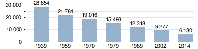
Note: census data
The largest villages besides the city of Oni (2656 inhabitants) are in the Georgian controlled part of the municipality with over 200 inhabitants each, the villages Ghari , Ghebi , Glola and Uzera (2014).
The municipality is divided into the independent capital Oni and 18 municipalities (Georgian temi, თემი or simply "village", Georgian sopeli, სოფელი ) with a total of 64 localities, four of which have no permanent residents:
| local community | Number of towns |
Population (2014) |
|---|---|---|
| Bari | 3 | 94 |
| Ghari | 2 | 388 |
| Ghebi | 3 1 | 424 |
| Glola | 1 | 279 |
| Gomi | 2 | 127 |
| Komandeli | 6 1 | 129 |
| Kwashchieti | 6 1 | 69 |
| Mrawaldsali | 1 | 7th |
| Paracheti | 5 1 | 184 |
| Pipileti | 4th | 150 |
| Sakao | 5 | 225 |
| Scheubani | 6th | 379 |
| Shkmeri | 3 | 52 |
| Sori | 3 | 199 |
| Tschiora | 1 | 116 |
| Uzera | 4th | 388 |
| Zchmori | 4th | 69 |
| Zedissi | 5 | 195 |
history
The territory of the municipality corresponds to the eastern part of the historical province of Ratcha, which was subordinate to local princes from the 11th to 15th centuries during the time of the unified Georgian feudal state, who temporarily ruled over the neighboring Svaneti to the west. After the disintegration of the united kingdom Racha was Lehns principality of the Kingdom of Imereti . In 1810 the area with Imeretia came to the Russian Empire and subsequently formed the Ujesd Ratscha in the Kutais governorate .
The Ujesd existed until the early years of the Soviet Union . From 1928 onwards there were several short-lived administrative changes until finally in October 1930 the independent Rajon Oni was spun off. From 1963 to the end of 1964 the Rajon was temporarily dissolved and its area was attached to the neighboring Rajon Ambrolauri. On April 29, 1991, the southern part of the area was severely affected by the worst earthquake ever recorded in this part of the Caucasus (magnitude 7.0 on the Richter scale ; MSK IX). In 1995 the Rajon Oni was assigned to the newly formed region of Ratscha-Letschchumi and Lower Svaneti and in 2006 it was transformed into a municipality.
traffic
The main traffic artery of the municipality is the national road Sch16 ( შ 16 ) following the Rioni from Kutaisi via Ambrolauri upwards , which continues above Oni through the valley of the left tributary Tschantschachi to the 2820 m high Mamisson pass over the main Caucasus ridge to Russia. The uppermost section with the pass is controlled by South Ossetia and is therefore closed. From Oni through the valley of the left Rioni tributary Jodzhora, the Sh27 ( შ 27 ) branches off in the direction of South Ossetia, to Kwaissa and on to the S10 (also Transcaucasian trunk road ) between Tskhinvali and Jawa (Dsau). As a result of the South Ossetia conflict, the Sch27 is also closed about 20 km from Oni above the village of Iri .
This means that the Sch16 is the only and, in connection with the Sch17 ( gehenden 17 ) in the direction of Tqibuli- Kutaisi, the shortest road connection to Central Georgia , which starts from the neighboring Ambrolauri municipal seat . The route from the Mamisson Pass via Oni, Ambrolauri and Tqibuli to Kutaisi corresponds to the historic Ossetian military road .
The nearest railway station is also in Tqibuli, the end point of a branch line from Rioni via Kutaisi since 1887 .
Web links
- Oni Municipality website (Georgian)
Individual evidence
- ↑ a b c Population Census 2014 ( Memento of the original from September 20, 2016 in the Internet Archive ) Info: The archive link was inserted automatically and has not yet been checked. Please check the original and archive link according to the instructions and then remove this notice. (English)
- ↑ Population Census 2002 ( Memento of the original from September 24, 2015 in the Internet Archive ) Info: The archive link was inserted automatically and has not yet been checked. Please check the original and archive link according to the instructions and then remove this notice. (English)
