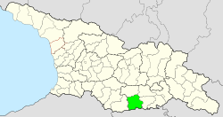
Municipality of Dmanissi
| Municipality of Dmanissi | |||
|---|---|---|---|
 |
|||
| Symbols | |||
|
|||
| Basic data | |||
| Country | Georgia | ||
| region | Niederkartlien | ||
| Seat | Dmanissi | ||
| surface | 1199 km² | ||
| Residents | 19,141 (2014) | ||
| density | 16 inhabitants per km² | ||
| ISO 3166-2 | GE-KK | ||
| Website | dmanisi.gov.ge (Georgian) | ||
Coordinates: 41 ° 24 ' N , 44 ° 6' E
The municipality Dmanissi ( Georgian დმანისის მუნიციპალიტეტი , Dmanissis munizipaliteti ) is an administrative unit (roughly equivalent to a district ) in the Niederkartlien region in southern Georgia .
geography
The administrative center of the municipality is the small town of Dmanissi . The 1198.8 km² municipality borders on the municipality of Bolnissi in the east, on a short section in the northeast on the municipality of Tetrizqaro and in the north on the municipality of Zalka , all also in the Niederkartlien region and in the west on the municipality of Ninozminda in the region Samtskhe Javakheti . In the south, the municipality is bounded by the state border with Armenia .
The largest part of the municipality is occupied by the low mountain range , which is forested in the eastern part and in the ridges reaches heights of 1500 to 1900 m . In the sparsely populated western part, the Javakheti Mountains rise to around 3000 m ; the highest peaks on the border with Samtskhe-Javakheti on the ridge are Emlikli ( 3054 m ) and Aghrikari ( 2972 m ).
Population and administrative division
With 19,141 inhabitants (2014), the population has fallen by almost a third compared to the previous census (28,034 inhabitants in 2002), well above the national average. However, the population decline has slowed compared to the decade after the collapse of the Soviet Union , when many Greeks in particular emigrated.
- Population development

Note: census data
The municipality is one of three municipalities in Georgia - next to Marneuli and Bolnissi, in which Azerbaijanis form the largest population group, here with 67%. They are followed by Georgians (31%) and a small number of Greeks (0.8%) and Russians (0.6%).
The largest villages besides the city of Dmanissi (2661 inhabitants) with over 750 inhabitants each are the villages of Amamlo , Irgantschai and Semo Karabulachi (2014), which are almost exclusively inhabited by Azerbaijanis .
The municipality is divided into the independent capital Dmanissi and 15 municipalities (Georgian temi, თემი or simply "village", Georgian sopeli, სოფელი ) with a total of 57 localities:
| local community | Number of towns |
Population (2014) |
|---|---|---|
| Amamlo | 6th | 2390 |
| Didi Dmanissi | 4th | 1512 |
| Dmanissi | 3 | 1146 |
| Gantiadi | 3 | 1367 |
| Gomareti | 4th | 719 |
| Guguti | 3 | 519 |
| Ipnari | 6th | 1104 |
| Irgantschai | 1 | 2014 |
| Kamarlo | 3 | 989 |
| Karabulachi | 10 | 1557 |
| Kisilkilissa | 2 | 551 |
| Maschawera | 2 | 651 |
| Orosmani | 5 | 1614 |
| Sakire | 2 | 57 |
| Sarkineti | 3 | 290 |
history
The municipality is located in the west of the historical Bortschali landscape , which formed a Ujesd in the Tbilisi governorate when it belonged to the Russian Empire and was predominantly inhabited by Armenians , Azerbaijanis and Greeks. During the period of the independent Georgian and Armenian republics , the area was disputed between the two states in 1918 and 1919. After it remained with Georgia, most of the Armenians emigrated from this part of the country.
In 1933, the Zalka Rajon, which had existed since 1930, was spun off as an independent Rajon, as was the administrative seat under the Azerbaijani name of Başkeçid ( Azerbaijani Başkeçid rayonu ; corresponding in Russian Башкечид , Bashketschid; Georgian form Bashkitschet ). In 1947 the city and Rajon received their current name of Georgian origin.
After the collapse of the Soviet Union, the economic performance of the municipality of Dmanissi fell sharply, accompanied by the emigration of over half of the population. Today the area is dominated by agriculture. The share of the administrative unit in milk production in Georgia is 2.3%, in wheat and potato production 2.4%.
In 1995 the Rajon was assigned to the newly formed region of Niederkartlien and in 2006 it was transformed into a municipality.
Web links
- Website of the Municipality of Dmanissi (Georgian)
Individual evidence
- ↑ a b c Population Census 2014 ( Memento of the original from September 20, 2016 in the Internet Archive ) Info: The archive link was inserted automatically and has not yet been checked. Please check the original and archive link according to the instructions and then remove this notice. (English)
- ↑ Population Census 2002 ( Memento of the original from September 24, 2015 in the Internet Archive ) Info: The archive link was inserted automatically and has not yet been checked. Please check the original and archive link according to the instructions and then remove this notice. (English)
- ^ Paul Goble: Tensions Between Georgian and Armenian Churches Escalate , Eurasia Daily Monitor, Vol. 11, No. 146, August 8, 2014. Online


