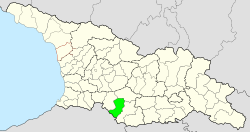
Aspindsa Municipality
| Aspindsa Municipality | |||
|---|---|---|---|
 |
|||
| Symbols | |||
|
|||
| Basic data | |||
| Country | Georgia | ||
| region | Samtskhe Javakheti | ||
| Seat | Aspindsa | ||
| surface | 825 km² | ||
| Residents | 10,372 (2014) | ||
| density | 13 inhabitants per km² | ||
| ISO 3166-2 | GE-SJ | ||
| Website | www.aspindza.gov.ge (Georgian) | ||
Coordinates: 41 ° 27 ' N , 43 ° 15' E
The municipality Aspindsa ( Georgian ასპინძის მუნიციპალიტეტი , Aspindsis munizipaliteti ) is an administrative unit (roughly equivalent to a district ) in the Samtskhe-Javakheti region in southern Georgia .
geography
The administrative center of the municipality Aspindsa is the eponymous minor city (Georgian daba , დაბა ) Aspindsa . The 825 square kilometer municipality is bordered to the west by the municipality of Akhaltsikhe , the north by the municipality of Borjomi and the east by the municipality of Akhalkalaki , which also includes all the region Samtskhe-Javakheti. The state border with Turkey runs in the southwest .
The Kura (Georgian Mtkvari ) flows through the municipality from the south to the northwest . In the north rises the Trialeti Mountains with its highest peak Shawiklde ( 2850 m ) in the extreme northeast, where the three municipalities Akhalkalaki, Aspindsa and Borjomi meet. To the southwest of the Kura rises the Erusheti Mountains (Georgian ერუშეთის ქედი , Erushetis kedi ), which extends into Turkey, where its highest peaks are, including the 3,033 m high Kel Dağı (Georgian ზიარეთი , Siareti ); the highest mountain of the range on the territory of Georgia is the Gumbati ( 2964 m ) in the southwest of the municipality Aspindsa not far from the state border.
Population and administrative division
At 10,372 inhabitants (2014), the population has decreased by around a quarter compared to the previous census (13,010 inhabitants in 2002), after having been relatively stable since the middle of the 20th century.
- Population development

Note: census data. 1944 Forced relocation of the Meshetes from the area (1939: 21,612).
82% of the population are Georgians , but the proportion of Armenians is also significant at 17.5% (2002).
The largest villages besides the main town Aspindsa (2793 inhabitants) are the villages of Chisabawra , Damala and Oschora (2014) with over 500 inhabitants each .
The municipality is divided into twelve municipalities (referred to as the “territorial organ ” for the minority town, Georgian teritoriuli organo, ტერიტორიული ორგანო , for the villages Georgian temi, თემი or simply “village”, Georgian sopeli, სოფელი ) with a total of 25 localities :
| local community | Number of towns |
Population (2014) |
|---|---|---|
| Aspindsa 1 | 2 | 3149 |
| Azqwita | 1 | 466 |
| Chisabawri | 3 | 1041 |
| Damala | 1 | 1234 |
| Dsweli | 2 | 661 |
| Idumala | 2 | 830 |
| Nakalakewi | 5 | 1166 |
| Orgora | 2 | 271 |
| Ota | 1 | 324 |
| Rustavi | 1 | 427 |
| Toloshi | 3 | 705 |
| Wargawi | 2 | 98 |
history
After the disintegration of the Kingdom of Georgia in the 16th century, the territory of the municipality was partly in the initially independent state structure Samtskhe-Saatabago (Meshetia), partly in Upper Javakheti, which was co-ruled for a time. Both were soon annexed by the Ottoman Empire . After the annexation of the area to the Russian Empire as a result of the Russo-Turkish War of 1828/29, it came to the Tbilisi Governorate and until the early years of the Soviet Union belonged largely to its Ujesd Akhaltsikhe , partly to the Ujesd Akhalkalaki .
In 1933 the independent Rajon Aspindsa was spun off. In November 1944, all members of the Mescheten , a Turkish-speaking ethnic group of predominantly Muslim faith, who at that time made up about two thirds of the Rajon's population, were deported to the Central Asian Soviet republics as part of a Stalinist resettlement campaign . The population of the area has not recovered from this event to this day, as, in contrast to other, economically more important parts of Georgia, only a few members of other ethnic groups were resettled there.
After Georgia gained independence, the Rajon was assigned to the newly formed Samtskhe-Javakheti region in 1995 and transformed into a municipality in 2006.
Attractions
The most important cultural monuments of the municipality are on the Kura above Aspindsa: the cave city of Vardsia from the 12th century and the cave monastery Wanis Kwabebi, which was built in the 8th century .
traffic
The international S11 road from Akhaltsikhe runs through the municipality of Aspindsa via Akhalkalaki and Ninozminda to the Armenian border, also part of the European route 691 . There is a connection to the capital Tbilisi both via Akhaltsikhe and Akhalkalaki – Ninozminda . The national road Sch58 ( შ 58 ) leads from the S11 up the Kura via Wardsia to the Turkish border . The municipality does not have its own rail connection; the nearest train stations are in the centers of the neighboring municipalities Akhaltsikhe and Akhalkalaki.
Web links
- Website of the Municipality of Aspindsa (Georgian)
Individual evidence
- ↑ a b c Population Census 2014 ( Memento of the original from September 20, 2016 in the Internet Archive ) Info: The archive link was inserted automatically and has not yet been checked. Please check the original and archive link according to the instructions and then remove this notice. (English)
- ↑ Population Census 2002 ( Memento of the original from September 24, 2015 in the Internet Archive ) Info: The archive link was inserted automatically and has not yet been checked. Please check the original and archive link according to the instructions and then remove this notice. (English)


