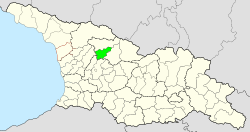
Zageri municipality
| Zageri municipality | |||
|---|---|---|---|
 |
|||
| Symbols | |||
|
|||
| Basic data | |||
| Country | Georgia | ||
| region | Ratscha-Letschchumi and Lower Swanetia | ||
| Seat | Zageri | ||
| surface | 756 km² | ||
| Residents | 10,387 (2014) | ||
| density | 14 inhabitants per km² | ||
| ISO 3166-2 | GE-RL | ||
| Website | tsageri.gov.ge (Georgian) | ||
Coordinates: 42 ° 36 ' N , 42 ° 48' E
The municipality Zageri ( Georgian ცაგერის მუნიციპალიტეტი , Zageris munizipaliteti ) is an administrative unit (roughly equivalent to a district ) in the Ratscha-Letschchumi region and Lower Vanetia in northern Georgia .
geography

The administrative center of the municipality is the small town of Zageri . The 756 km² municipality borders on the municipality of Lentechi in the north and on the municipality of Ambrolauri in the east , both also in the Ratscha-Letschchumi region and Lower Vanetia, in the south on the municipality of Zqaltubo and in the southwest on the municipality of Choni , both in the Imereti region , and in the northwest to the municipality of Martwili in the Mingrelia and Upper Svaneti region .
The municipality extends in the valleys of the Rioni rivers with its right tributary Ladschanuri and the middle reaches of the right Rioni tributary Zcheniszqali . From the southern part of the historical province of Svaneti , called Lower Svaneti (Georgian Kwemo Svaneti ), today the municipality of Lentechi, the municipality is separated in the northwest by the Egrissi Mountains with the 3174 m high Zikuri, in the northeast by the Letschchumi Mountains with the 3152 m high Lelaaschcha as the highest peak in this area. The western part of the Ratscha Mountains, which is a good 1400 m high, extends into the southeast of the municipality . The 1997 m high summit of Chwomli rises between the Rioni and Zcheniszqali valleys in the south , while the municipality is bounded in the west by the steep slope of the Aschi plateau , which is over 2300 m high .
Population and administrative division
With 10,387 inhabitants (2014), the population of the municipality has fallen by more than a third compared to the previous census (16,622 inhabitants in 2002), which accelerated the trend of a continuous population decline that had been ongoing since at least the 1930s (32,281 inhabitants in 1939).
- Population development

Note: census data
The largest villages besides the city of Zageri (1320 inhabitants) are the villages of Kweda Zageri , Orbeli and Tschchuteli (2014), each with over 500 inhabitants .
The municipality is divided into the independent capital Zageri and 18 municipalities (Georgian temi, თემი ) with a total of 58 localities:
| local community | Number of towns |
Population (2014) |
|---|---|---|
| Aghwi | 4th | 279 |
| Alpana | 4th | 464 |
| Ghwirischi | 5 | 491 |
| Kweda Zageri | 3 | 1402 |
| Lailaschi | 4th | 520 |
| Lasuriaschi | 4th | 726 |
| Luchwano | 3 | 229 |
| Nakuraleschi | 2 | 92 |
| Oqureschi | 2 | 414 |
| Orbeli | 5 | 1231 |
| Sairme | 2 | 190 |
| Spatagori | 3 | 268 |
| Subi | 3 | 612 |
| Tschchuteli | 3 | 664 |
| Tschkumi | 2 | 217 |
| Twischi | 4th | 474 |
| Ussachelo | 2 | 274 |
| Zipertschi | 3 | 520 |
history
The territory of the municipality corresponds to the central part of the historical Letschchumi province , which was subordinate to the princes of Svaneti and then to the princes of Ratcha during the time of the unified Georgian feudal state from the 11th to the 15th centuries . After the collapse of the unified empire, it first came to the Kingdom of Imeretia in 1455 and then became de facto independent under the local aristocratic family Chikowani , before it was united with this principality in 1714 through family ties to the Dadiani of Mingrelia . In 1857 the area came with the entire Principality of Mingrelia to the Russian Empire and, as a result, formed the southern part of the Ujesds Letschchumi in the Kutais Governorate .
The Ujesd existed until the early years of the Soviet Union . In 1930 the independent Zageri district was spun off. After Georgia gained independence, the Rajon was assigned to the newly formed Ratscha-Letschchumi and Lower Svaneti region in 1995 and converted into a municipality in 2006.
traffic
The national road Sch15 ( შ 15 ) runs through the valley of the Zcheniszqali , which leads from Kutaisi via Zqaltubo - there is also the nearest train station - coming via Zageri on to the municipality of Lentechi. The Sch16 ( შ 16 ) also leads through the Rioni Valley from Kutaisi towards Ambrolauri - Oni . The Sch18 ( შ 18 ) connects both roads along the Ladschanuri River via Orbeli to Zageri.
Web links
- Zageri Municipality website (Georgian)
Individual evidence
- ↑ a b c Population Census 2014 ( Memento of the original from September 20, 2016 in the Internet Archive ) Info: The archive link was inserted automatically and has not yet been checked. Please check the original and archive link according to the instructions and then remove this notice. (English)
- ↑ Population Census 2002 ( Memento of the original from September 24, 2015 in the Internet Archive ) Info: The archive link was inserted automatically and has not yet been checked. Please check the original and archive link according to the instructions and then remove this notice. (English)


