
Chochatauri municipality
| Chochatauri municipality | |||
|---|---|---|---|
 |
|||
| Symbols | |||
|
|||
| Basic data | |||
| Country | Georgia | ||
| region | Guria | ||
| Seat | Chochatauri | ||
| surface | 825 km² | ||
| Residents | 19,001 (2014) | ||
| density | 23 inhabitants per km² | ||
| ISO 3166-2 | GE-GU | ||
| Website | chokhatauri.ge (Georgian) | ||


Coordinates: 41 ° 54 ' N , 42 ° 24' E
The municipality Tschochatauri ( Georgian ოზურგეთის მუნიციპალიტეტი , Tschochatauris munizipaliteti ) is an administrative unit (roughly equivalent to a district ) in the Guria region in western Georgia .
geography
The administrative center of the 825 km² municipality of Tschochatauri is the eponymous minority (Georgian daba , დაბა ) Tschochatauri .
In the west and northwest of the municipality chokhatauri from the Gurian municipalities will ozurgeti and lanchkhuti , in the north-east and north-east by the municipalities Samtredia and Wani in the region of Imereti , in the southeast of the municipality Adigeni in the region Samtskhe-Javakheti of and in the south by the municipalities Adjara Autonomous Republic limited to Shuachewi and Chulo .
The municipality is mainly located in the sparsely populated area of the Mescheti Mountains with its highest mountain Mepiszqaro ( 2850 m ) in the extreme southeast. In the north, the area is by only up almost 700 m high, but striking Sairao comb to Colchis Plain limited. The most important river, the Supsa , flows through the administrative center ; Its largest tributary, the Gubaseuli, flows a little below .
Population and administrative division
With 19,001 inhabitants (2014), the number of inhabitants has decreased by more than a fifth compared to the previous census (24,090 inhabitants in 2002). The population decline, which had continued steadily since at least the 1930s (34,549 inhabitants in 1939), continued at an accelerated rate.
- Population development
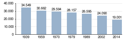
Note: census data
The population is almost mono-ethnic Georgian (about 99.5%); there are also a small number of Russians , Armenians and Ossetians .
The largest villages besides the main town of Chochatauri (1815 inhabitants) are the villages of Buknari , Gogolessubani , Guturi , Schua Amaghleba , Semo Parzchma and Soti (2014), each with over 700 inhabitants .
The municipality is divided into the independent minority town of Chochatauri and 22 communities (Georgian temi, თემი or simply "village", Georgian sopeli, სოფელი ) with a total of 61 localities:
| local community | Number of towns |
Population (2014) |
|---|---|---|
| Amaghleba | 2 | 1073 |
| Bukiskikhe | 2 | 726 |
| Chewi | 3 | 477 |
| Chidistawi | 6th | 1173 |
| Dablaziche | 2 | 681 |
| Didiwani | 3 | 86 |
| Blackchma | 3 | 939 |
| Erketi | 5 | 817 |
| Gogolessubani | 1 | 858 |
| Gorabereschouli | 1 | 628 |
| Guturi | 1 | 880 |
| Kochnari | 4th | 1276 |
| Kwenobani | 3 | 1768 |
| Nabeghlawi | 4th | 830 |
| Parzchma | 2 | 1373 |
| Satschamiasseri | 4th | 713 |
| Schua Amaghleba | 1 | 735 |
| Schua Surebi | 1 | 178 |
| Semo Surebi | 7th | 250 |
| Semocheti | 3 | 218 |
| Soti | 1 | 893 |
| Wansomleti | 2 | 614 |
history
From the collapse of the Kingdom of Georgia in the early 15th century until the 19th century, the territory of today's municipality belonged to the Principality of Guria. After the annexation to the Russian Empire it became part of the Ujesds Gurien. This existed with different administrative assignments until the Soviet period, when the Chochatauri Rajon was spun off in 1930 . Apart from a short break from 1962 to 1963 (affiliation to the Osurgeti Rajon), this administrative unit still exists on a practically unchanged area. After the independence of Georgia in 1995 it was attached to the newly formed Guria region and in 2006 it was converted into a municipality.
traffic
The most important traffic axis is the national road Sch2 ( შ 2 ), which comes from Sadschawacho near Samtredia through the northwest part of the municipality with Tschochatauri and continues via Osurgeti to Kobuleti on the Black Sea . In Tschochatauri the national road Sch81 ( შ 81 ) branches off, which opens up the southern, mountainous part of the municipality and ends in the resort of Bachmaro (part of the municipality of Nabeghlawi) at a height of 1900 m .
The municipality is not connected to the railway network. The nearest train stations are located a good 10 km north of Chochatauri in Sadschawacho on the Samtredia - Batumi route and in the administrative center of the neighboring municipality of Osurgeti to the west, a good 20 km from Chochatauri.
Web links
- Website of the municipality of Chochatauri (Georgian)
Individual evidence
- ↑ a b c Population Census 2014 ( Memento of the original from September 20, 2016 in the Internet Archive ) Info: The archive link was inserted automatically and has not yet been checked. Please check the original and archive link according to the instructions and then remove this notice. (English)
- ↑ Population Census 2002 ( Memento of the original from September 24, 2015 in the Internet Archive ) Info: The archive link was inserted automatically and has not yet been checked. Please check the original and archive link according to the instructions and then remove this notice. (English)
