
North York Moors
| North York Moors | |
|---|---|
 Map of the North York Moors |
|
 Fylingdales Moor with the A170 road, Fylingdales RAF in the background |
|
| Highest peak | Round Hill ( 454 m ASL ) |
| location | North Yorkshire , England , UK |
| Coordinates | 54 ° 24 ′ N , 1 ° 5 ′ W |
| rock | Sandstone, limestone |
| surface | 1,436 km² |
The North York Moors are a plateau in North Yorkshire in north east England . The 1436 km² area, located southeast of Middlesbrough directly on the North Sea , rises about 300 to 400 meters above the surrounding area, which is almost at sea level. The moors are shaped by the river valleys called Dales , most of which slope south of the main ridge in a southerly direction to the River Derwent . The exception is Eskdale, which runs north of the main ridge essentially from west to east.
Sandstone and limestone formations withstood the last cold ages . The location directly on the North Sea ensures a comparatively harsh climate. Fauna and flora correspond to what is otherwise only found in Great Britain at higher altitudes. The plateau is characterized by wide heathland landscapes , which merge into wide areas of ferns on the slopes. Agriculture and human settlement are largely limited to the Dales and the southern peripheral areas with fertile limestone soils.
The actual plateau has been shaped by sheep breeding for centuries. It is now subject to landscape management, which is intended to ensure the best possible living conditions for the huntable Scottish red grouse . The moors have been protected as the North York Moors National Park since 1952 . The up to 200 meter high cliffs on the coast and some well-known long-distance hiking trails that traverse the area also contribute to its popularity as a holiday destination .
Location and structure

The national park occupies a closed area of 1436 km². The North Sea forms the eastern border ; however, a small area of land around the mouth of the River Esk at Whitby is excluded from the national park. In the other directions, the moors are bounded by plains: the Vale of Mowbray forms the border to the west, the Vale of Pickering to the south and the Cleveland Basin with the River Tees valley to the north . The moors are about 60 kilometers wide in an east-west direction and extend about 35 kilometers in a north-south direction.
The national park area belongs mainly to the county of North Yorkshire and is there in the area of the districts of Hambleton , Ryedale and Scarborough . A small part in the north already belongs to the independent administrative unit Redcar and Cleveland , which is only counted in North Yorkshire on ceremonial occasions. While the park in the north with Teesside is surrounded by an industrial area with clear structural problems in the last few decades, a comparatively affluent service region is expanding in the south with the university city of York and its surrounding area. To the west rise behind the Vale of Mowbray, the hills and mountains of the Yorkshire Dales and the Lake District national parks .
About 35% of the national park area is covered by semi-natural heather - moorland . The moors are home to the largest area of heather moorland in England and Wales. About 40% is arable land. The rest consists mainly of forest, of which a large part is taken up by conifer forests, which only emerged in the last few decades. 44,000 hectares of the heathland have been designated a Site of Special Scientific Interest . It is the largest inland area of this form of protection in the United Kingdom. The 26 mile long coastline on the North Sea forms the main part of the North Yorkshire and Cleveland Heritage Coast . It is shaped by cliffs and occasionally sandy beaches. In the southwest the park borders directly on the Area of Outstanding Natural Beauty of the Howardian Hills .
Climate and geology
climate
Of the hill regions of the British Isles, the North York Moors are the driest, mainly due to its eastern location. The amount of rain is between 760 and 1015 mm / year, with more rain falling at higher altitudes. The average summer temperature is 15 ° C in the lower areas and 12.7 ° C in the high areas, the winter temperature is 2.7 and 1.7 ° C respectively. There are big differences depending on the local wind conditions. Frost occurs on average 50 to 75 days per year, depending on the altitude. Northern winds influence the snowfall, so that the 20 days of snow in the lowlands and the 40 days of snow on the hills are roughly equivalent to the level of the substantially higher Pennines. The last snow, like in the Pennines, can still occur in May.
geology
Jurassic sandstone formations

Geologically, the park is shaped by three formations from the Jura . It is the geologically youngest highland plateau in Great Britain. The oldest layers date from the Lower Jurassic (Lias) and consist of marine deposits in the form of silt and clay stones . These layers are mainly in valleys as in the bed of the Esks, in Rosedale or on the cliff face the North Sea open . Above this is the so-called "Ravenscar Group". These deposits flattened the original sea basin and a huge river delta was formed in what is now the moors. The Jurassic sandstone formed in the process , whose sedimentary structures are typical of delta deposits, is the dominant type of rock in the moors. The three types of rock result in less fertile soils. However, they contain deposits of iron ore , alums and gagat , which were mined from the Middle Ages until the 20th century. For several years there has been a potassium carbonate mine near Boulby , from which the salt is extracted from a depth of 1200 to 1500 meters.
The landscape of the moors differs markedly from the nearby mountains such as the Yorkshire Dales or the Pennines . The central part is a high plateau at a height of around 360 meters and higher, in which comparatively wide valleys with steep slopes, the dales , have cut. The highest point is the Round Hill, made of Jurassic sandstone, on Urra Moor at 454 meters. The whole area is crossed by a saddle that runs in an east-west direction and clearly reaches the coast at Robin Hood's Bay, for example . This saddle forms the watershed between the tributaries of the Esk in the north and the tributaries of the Derwent in the south. In the sandstone areas in the west and north, steep slopes with a height difference of approx. 300 meters characterize the border between the Dales and the plateau. Likewise, the highest sea cliff in Great Britain, 203 meters high, drops off at Boulby in the extreme northeast of the moors to the North Sea. The border to the neighboring plains is marked by steep mountain ranges in the north and west. With the roseberry topping there is a conical, single standing sandstone formation. The highest hills in the west are the Cleveland Hills with a little over 400 meters, which merge into the limestone formation of the Hambleton Hills with a height of 300 to 400 meters in the southwest.
Limestone in the south

During later phases, today's moors were again well below the sea floor; Coral reefs and their sediments formed the basis for the limestone segments of the moors that exist today . These limestone hills are the Hambleton Hills in the extreme southwest or the Tabular Hills , which form the border with the Vale of Pickering in the south . While the Hambleton Hills are demarcated from the Vale of York by steep slopes , the gradient on the Tabular Hills is significantly less, the landscape here has a gently swaying appearance. In the limestone areas, the organic source material ensures a much more fertile soil than in the rest of the moors. Agriculture and human settlements have always been concentrated in these fertile peripheral areas of the moors.
Rivers and dales

Two river systems drain the moors that are separated by a watershed at the east-west saddle. In the north, the Esk flows from Westerdale to the east and ends after 40 kilometers at Whitby in the North Sea. There is fertile farmland on its banks. The most important river in the south of the moors is the Derwent , which flows from Fylingdales Moor eastwards and westwards again just before the coast into the Ouse , before finally flowing into the North Sea in the Humber .
The Dales run along the rivers in a north-south direction. South of the watershed - in the direction of the Derwent - the dales in the sandstone regions are wide and space-consuming. In the southern section of the moors, the rivers have cut deep and winding into the limestone and form narrow valleys in the Tabular Hills. In the north, the dales are often steeper and narrower, even in the sandstone formations, in the rivers and streams there are often large, single, sanded rocks that have withstood the water so far. The esk itself runs in a geological fold . As the only valley of the moors, it runs east-west and not north-south. It is much wider and more expansive than the other dales.
Influence of the ice ages
Various ice ages shaped the landscape until 12,000 years ago . During the Saale Ice Age , ice completely covered the moors. During the last ice age, the Vistula Ice Age , the hill tops were covered with snow, but the glaciers from Scandinavia and northern Great Britain were held back by the hard sandstone formations in the north of the moors. Glacial remains of the last ice age can only be found in the north of the area. On the steep coast and the southwestern slopes of soft limestone, the passing glaciers created rugged slopes.
fauna and Flora
The dry and cool climate, which is atypical for the British Isles, as well as the openness of the landscape have ensured that numerous species have settled in the North York Moors that are otherwise only found at higher altitudes. There are a total of 31 mammal species, 123 breeding bird species and 850 different plants.
Original shape
Pollen analyzes in the soil show that around 8000 BC And before human settlement, continuous forest covered the moors. Birch, hazel and Scots pine dominated the vegetation. Only a few swamps in the development stage and hill tops or slopes particularly exposed to the weather could have been free of forest. With the beginning of human settlement, the residents began to cut wood according to plan in order to build houses, heat them, and let their cattle graze on the pastures that were created. At that time, methodical pasture management and clearing work began, so as not to create new forests and thus agriculturally unusable land. As a result, extensive heathlands spread , swamps and bogs emerged, and the soil lost many nutrients.
In the years 3100 BC Until about 2600 BC BC residents also began to deforest the hills above about 350 meters height by slash and burn . At around the same time, the traces of pollen from elms, linden and ash trees disappear. The exact reason is not known, but human clearing measures are probably responsible here too. After waves of colonization and retreat, people began to clear the last of the larger forests in the moors in the Iron Age . Heavy rain and rising water levels in numerous dales had transformed them into inaccessible marshland , so that strong settlement pressure arose even on higher regions. Isolated forest areas could only survive on steeper hill slopes. The original forest had disappeared at the beginning of Roman rule in 70 AD, the heather areas probably already had their current appearance in general.
Heathland
.JPG)

The current shape of the North York Moors was formed through millennia of human cultivation. If this were to be discontinued, bushes and later the original birch, hazel and pine forests could form again in some time. Its current shape has shaped two types of use in the last few centuries: originally grazing with sheep for wool production, but today mainly intensive landscape maintenance in order to be able to hunt the Scottish red grouse .
The heathland is between 250 and 400 meters high in the middle of the North Sea wind. The site is generally open, only small areas are fenced. The dominant plant species are common heather and blueberry . These prefer acidic, barren and, for the area, dry terrain, while cotton grasses and other grasses settle in even more humid or marshy areas of the plateaus .
Not only grouse benefit from caring for the heather, but also various waders such as curlew , golden plover , lapwing and some snipe birds . The main predators are merlin and peregrine falcon . The preferences for certain moorland areas change: while the Merlin prefers high and old heather areas, for example, the waders are mainly in areas where the heather was recently burned. Adder and forest lizard use the moors as an important retreat.
At lower slopes mainly grows Bracken . On the slopes there are frequent springs, streams, ponds and their banks, which are home to numerous plant species and small animals. For unknown reasons, the fern areas have expanded significantly in recent decades. It is assumed that the fern will find better living conditions also in the higher altitudes due to global warming . It could also be possible that previous grazing with cattle prevented the fern from spreading. They can safely consume the fern when it is young. For sheep, on the other hand, the fern is not digestible at all stages of growth. While some fern covered ground birds such as the Whinchat provide habitat, national park administration and conservationists prefer Europe far more rare heathland and try to prevent the spread of ferns. Farmers are opponents of the fern because it is poisonous and sheep do not eat it. The fern areas are also unpopular with hunters and tourists as they often harbor ticks .
Fields, meadows and rivers

With around 20% of the area, North York Moors National Park has a comparatively high proportion of area for a British national park, which is suitable for intensive agriculture , which is particularly true of the limestone formations in the southwest. While in the 1930s there was often a system in which arable farming was carried out in the Dales and animals grazed on the hills, specialization has now established itself: arable farming takes place almost exclusively in the south-west, animals graze in the other areas of the moors.
Although some walls and other field boundaries are significantly older, the current shape of the arable land has developed over the past 500 years in particular. Fields on the flatter slopes to the valley as well as in the valley are mainly used for hay extraction and mowing . There are marshland and alluvial forest zones that serve as a habitat for various birds. Traditional dry stone walls and hedges still form the most common field boundaries and provide a habitat for numerous animals. However, these are gradually being replaced by fences. Individual farms that stand on the heather-covered moorland of the plateaus are often framed by sycamores . Wheat , barley and rapeseed dominate the areas with intensive arable farming . There are some mass pig farms in the Helmsley area to the southwest .
Various aquatic animals are found in the rivers of the Dales. The Esk, in particular, is rich in wildlife, which includes lake trout , salmon, and river pearl mussels . The occurrence of otters and jackdaws is of particular importance for nature conservation .
Woods
Forests take up around 22% of the national park area. These are mainly on the Forestry Commission land or on the land of large landowners. Most of them have only been created in the last few decades and are primarily used to harvest wood with rapidly growing conifers. Since a policy change by the Forestry Commission in 1983 in favor of deciduous forests with higher recreational and recreational value, however, a slow change has emerged here.
Currently three quarters of the forests consist of fast-growing conifers, of the remaining 6,700 hectares of mixed deciduous forest, 2,200 are protected as a Site of Special Scientific Interest . To a small extent, these are old forests that are located in very narrow valleys, steep slopes or in inaccessible coastal areas, and have never been subject to intensive human use. Larger parts, especially in the Hambleton Hills, were used for logging for centuries. These forests were mostly planted using the stick and coppice system. The landowners let individual trees grow for decades in order to obtain long, straight pieces of wood, the trees between them were regularly harvested every few years in order to gain cuttings for other woods. In today's deciduous forests, this former forest use can be seen well, especially as numerous trees have multiple trunks on a base that grew from the last generation of the cane rash.
Most of the coniferous forests date from the 1950s to 1970s. Although they would then be ripe for harvest, the costs of harvesting and replanting and the wood prices have diverged so much over the past few decades that harvesting, especially on slopes, would be a considerable loss. Where wood production is still worthwhile, the Forestry Commission only operates it to support its main goals of nature conservation and recreational value. Examples are Newtondale or Dalby Forest . Both forests, which only emerged in the 20th century on former moorland and arable land and have since been converted into recreational forests with various leisure activities and diverse vegetation. The income from forest tourism and other offers exceeds the income from sales of wood, even for the Forestry Commission. Attempts to grow a semi-natural forest again on individual slopes and in fern areas failed due to the timber policy of the last decades. Due to the abundant seed sources in the area, unwanted spruce and pine forests are largely emerging again.
history
Prehistory and early history

The early inhabitants of the Moors were probably not more numerous than their contemporaries in other areas of northern England. Since the moors have remained relatively untouched since then, considerably more archaeological sites have been preserved than in neighboring areas. In total there are around 15,000 sites in the moors, 700 of which are protected as scheduled monuments . Ever since miners discovered a large deposit at Hodge Beck on the southern edge of the Moors in 1821 , in which mammoth, lion and rhinoceros bones were found, as well as flint stones from the Mesolithic , dozens more Mesolithic deposits have been discovered in higher-lying caves of the Moors. Archaeologists also collected large amounts of microliths and their remains on the hills. For example, one spot on Snilesworth Moor was completely exposed after a fire and contained 5,000 flint stones within an 8 meter radius. It can no longer be determined whether the hunters and gatherers of the Stone Age stayed permanently in the moors, or basically lived on the coast and undertook extensive hikes into the moors. For the Bronze Age, however, a deterioration of the soil in the interior of the moors as well as a sharp decrease in human traces can be determined.
The remains of around 10,000 barrows from the bell-cup culture survived on the southern edges of the moors . The reclamation of the land was now carried out on a more planned and long-term basis. Individual farms can be reconstructed. The farms and fields were in the fertile valleys, while in summer the cattle grazed on the hills and the people used the hills for hunting. The most striking legacies of this time are Cairnsfields , valleys in which numerous small piles of stones ( Cairns ) mark the landscape. Some valleys like Iron Howe in the northwestern Moors contain hundreds of these heaps. While the Cairns were previously often mistaken for waymarks or grave markers, the explanation has now gained acceptance that the great majority of them were used to collect stones that were left over from field clearing. On the hills and elevations themselves, however, there are significantly larger piles of stones, seven to 35 meters in diameter, often distributed in long lines across the country - these presumably marked the boundary between the individual settlement areas. There are around 200 completely preserved barrows from the Bronze Age, most of them by discovered them by Victorian antique dealers. Of these, some are located in places with a wide panoramic view of the country. These are also the most precious of all barrows.
Several moats and border structures have been preserved from the Bronze Age and the Iron Age . The trenches in the Levisham Estate , which are still relatively well preserved, are striking . They date from before the Iron Age but are not dated with any certainty. The Cleave-Dyke system is located directly on the south-eastern edge , the most striking part of which is the former fortress of Boltby Scar . Here, too, the dating is uncertain, the marriage of the complex may be in the late Bronze Age. Since the excavation documents from the beginning of the 20th century are almost completely lost, and a farmer leveled Boltby Scar with a bulldozer in 1961, even today's archaeologists have great problems making definitive statements about the facility during the excavations that have been going on for a few years.
Around 1500 BC BC the climate deteriorated noticeably, it became both colder and wetter. The increasing rain washed more nutrients from the soil, larger areas became marshy. Peat and heathland spread out over the hills. The rivers and their marshland expanded in the valleys .
Romans, Anglers, Danes and Norwegians
In the time of Roman Britain , the moors were on the periphery. Only a few artifacts from this period have survived. Above all, the Romans stayed on the southern edges, the only larger known structure in the moors is a road in north-south direction from Malton to Guildsborough . Like the few fortresses, this one was built in the early days of the Roman north of England, around the years 80–90. The only two fortifications found, Cawthorn and Lease Rigg, date from before the year 120, but it is uncertain whether they were permanent structures at all. A possible remnant of this road, Wade's Causeway , is one of the few Roman roads in the British Isles that can still be seen in its original form in the landscape today. After the Roman rule was consolidated here, there are no other fortresses. During the greatest period of Roman Britain, the moors were free from the army, and there were few signs of other Roman settlement. It was only when attacks on the North Sea increased in the final phase of Roman Britain that signal towers were built on the coast of East Yorkshire to inform the fleet of approaching ships of the North Sea peoples.
Anglers and Danes mainly left place names. Thereafter, the fishing area stretched along the Tabular Hills, while the Danes left their traces mainly on the northern and western edges of the moors. Individual stone crosses such as the Young Ralph Cross are often still present from this period . Individual villages, independent of each other and of the environment, determined the image of the landscape. Typical examples are Gillamoor or Spaunton , which have largely retained their medieval settlement structure to this day.
Monasteries in the High Middle Ages

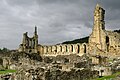
Rievaulx Abbey , the largest Cistercian monastery in the moors.

Rievaulx Abbey in fertile Ryedale, once one of the great landowners.

Whitby Abbey on the North Sea coast
Former Cistercian monastery Byland Abbey on the southern edge


In the 12th century, monastic orders began to divide the moors among themselves, with the Cistercians predominating. Originally they were attracted to the lonely, remote location and they built monasteries . After the Cistercian order relaxed the rules of the necessary asceticism and the monks in the moors had explored the possibilities of extensive sheep keeping, lucrative sources of income also lured here. Large complexes such as Rievaulx Abbey and Byland Abbey emerged, which developed into large landowners in the moors. At that time wool was England's main export good, woven into clothing on the continent and traded dearly as far as Florence . Yorkshire was a center of English sheep breeding, which in turn concentrated there on moorland. Individual monasteries such as Rievaulx owned around 12,000 sheep when they married, out of a total of at least 50,000 to 60,000 animals in the North York Moors. This period ended with the dissolution of the English monasteries in 1536; the lands mostly passed into the hands of nobles.
Early modern age

In the early modern period , Britain's population increased significantly. Settlement pressure also increased in more remote areas such as the North York Moors. People used the landscape more intensively and began to focus more intensively on the extraction of natural resources. The earliest written evidence of the mining of coal comes from the year 1643 . The seams were numerous, but often only 15 to 20 centimeters thick, so that at that time thousands of small pits were created from which the residents extracted coal. At Danby in the Esk Valley, an underground construction with several shafts dug into the ground was being built at this time. In the same area was the center of alum mining. This is documented for the first time in 1604; In 1700 16 opencast mines were already active. This mining in particular had a strong impact on the environment, as up to 100 tons of slate have to be dug up to extract one ton of alum. Under the conditions at the time, the slate also had to be heated for up to nine months in order to extract alum - a process that required extraordinary amounts of fuel.
Pasture farming is the traditional form of farming that farmers practiced with various species of animals until the 19th century. This only began to change with the breeding of weather-insensitive sheep breeds that could easily stay on their pastures in winter. In general, the sheep in the moors were already distinguished in the 17th century by the fact that they were comparatively well adapted to stormy and humid climates. It had coarse wool, all animals were horned, and their faces were mostly dyed black. Today's specialized breeds did not develop until the late 18th and 19th centuries. While the rough fur was bred in the moors, it now occurs further north of England; Cheviot and Scottish Blackface and their crossbreeds are predominantly to be found in the moors . Problems also arose: sheep as selective grazing animals now, as then, mainly eat grass; However, only heather when she is young. Over the decades a vegetation began to form that consists almost entirely of old woody heather and offers little food for the sheep. The farmers therefore began to burn the heather down at regular intervals, so that ideally no plants older than ten years would grow in the area.
Mining and industrialization

Sandstone from the moors was a widespread building material in the Middle Ages. It was used as a road surface as well as for covering roofs as far as London . In the Lower Jurassic to iron deposits were formed, which at the time of industrialization of a major iron industry in Grosmont led. There are seven important iron ore veins in the sandstone mountains, all of which have been known since the Middle Ages and from which rock was already being mined at that time. Rievaulx Abbey probably already operated its own blast furnace . Apparently there was a pause between 1650 and 1800, before mining increased again from 1800. Much of it was chopped off the coastal cliffs in boats, most of it was transported to Tyneside for further processing. More economically significant was the mining on the largest veins at Teesside , Rosedale and the Esk Valley . Individual places near these mines such as Rosedale Abbey or Grosmont built their own blast furnaces.
For example, in Rosedale Abbey - located in Rosedale in the central part of the Moors - there was a Cistercian monastery from 1158 to 1536, which was subsequently abandoned. It was only after the discovery that the iron ore there was particularly rich with 45% iron that a railway to Rosedale was built, as were large mines and kilns, the remains of which can still be seen today. The boom lasted roughly from 1850 to 1920; after that the iron ore deposits were exhausted. At that time on a smaller scale, meanwhile grown significantly and still active are the quarries for limestone in the hills of the Moors to the south. The construction of lime kilns, in turn, led to increased mining of hard coal on site in order to be able to operate it. This lasted until 1890 when the last lime kiln in the moors was shut down. The processing of the limestone now takes place outside of the moors.
As a national park
The British national park movement developed in the 1930s. Mainly supported by the Ramblers' Association , it called on the one hand to open up private land to hikers and those interested in nature, and on the other hand to preserve nature. They saw national parks based on the American model as an effective means of doing this. In particular, the new national parks should offer workers an opportunity to leave the densely built-up industrial cities at least one day a week. They should increase public health , and so should workers' productivity. While the movement had broad support across the political camps, the rural communities in particular resisted. They feared being overrun by crowds and losing control of their land. In particular, they feared the mass appearance of the working class and all the accompanying disturbances to rural peace.
Interrupted by the Second World War, the national park movement gained importance in the late 1940s. The Hobhouse Report of 1949 outlined the essential baselines of the future national parks, but did not see the moors in the list of future national parks. In the deliberations on the " National Parks and Access to the Countryside Act 1949 ", the parliamentarians finally also determined the North York Moors as a future protected area. They have been designated a national park since 1952 under the National Parks and Access to the Countryside Act 1949, enacted in 1949. They are intended to fulfill the dual function of a national park in the United Kingdom: on the one hand, to protect nature, and on the other, to enable the public to enjoy this nature.
In the first years after the establishment of the national park, the topic of afforestation dominated the debates about the future of the park. The Forestry Commission , which owns over 15% of the national park area, was founded after the First World War with the aim of ensuring a self-sufficient wood supply for Great Britain. To do this, they should create commercial forests on poor soil. In the North York Moors she planted fast-growing, but ecologically little valuable conifer forests. In the 1950s and 1960s there was a conflict with residents, tourists and conservationists. The debate about the future role of the Forestry Commission sparked primarily on the forests in the Peak District and the North York Moors.
The construction of an immense radar system for RAF Fylingdales in 1960 and the Boulby mine could not be prevented by conservationists.
Further debates followed when Parliament wanted to build a reservoir in Farndale in 1970 to generate energy. After reservoirs in the UK had been set up in the United Kingdom without considering environmental protection and scenic beauty, the Farndale project clearly failed for precisely these reasons. When such a plan failed in Parliament in 1969 in the Hebden Valley , also in Yorkshire, Farndale finally meant the end of such dam programs.
In the decades after the Second World War, with government support, farmers began to farm more in the moors again. They planted the edge areas with larch, pine and Sitka spruce , and they tried to improve the moor areas themselves with fast-growing grasses. Due to public protests and a change in agricultural policy, they discontinued these measures in the 1980s. Between the time it was designated a national park and 1975, around 15,000 hectares of moorland disappeared, most of which were converted into commercial forests. A quarter of the total heather population in the park was lost.
Landscaping
Landscape maintenance for grouse hunting

Grouse hunting represents an important source of income for large landowners, which makes it lucrative to design the moors as an ideal habitat for grouse. Maintaining the heather, which gives the landscape its characteristic appearance, requires extensive land management. The grouse need both young heather for feeding and older heather for hiding. In order to meet these requirements, grazing sheep and controlled burns are used. In the medium term, grazing alone would create landscapes with old heather that are no longer edible for sheep - the landscape would be overgrown. Since the commercial grouse hunt is now more economically important than the direct income from sheep breeding, the maintenance of the moors in their current state is financed primarily by large landowners who offer hunting. Both the national park administration and the nature conservation organization Natural England would prefer a lower level of burn-up and higher levels of heather.
In the long term, the management poses problems: During the controlled fires, ash rises with the nutrients it contains and spreads far across the country. The loss of nutrients on site is rather small compared to the overall balance; However, since the owners have been using this technology for many decades, it leads to a long-term impoverishment of the soil. Likewise, the ability of the soil to hold water has been declining for decades; it becomes drier and the risk of uncontrolled spontaneous inflammation, with potentially disastrous effects, increases steadily. Particularly large fires like those of 1904, 1909, 1947 and in Glaisdale Moor in 1976 have left clear marks on the landscape. The fire of 1976, for example, burned deep into the peat soil, where it could exist as a peat fire for some time and also destroyed the roots and seeds of the plants. A total of 600 hectares of heather burned. Investigations ten years later showed that only 6% of the area had vascular plants again , 65% of the area was covered by mosses and 30% of the fire area was still completely fallow after 10 years. Significant erosion losses also occur in the period up to the re-colonization by plants. Rarer fires also carry a risk: A major fire in 2003 occurred mainly because the heath had grown too high in the time since the last fire. The fire of the originally controlled fire got out of control.
In order to counteract the disadvantages of grazing with sheep, but also to respond to the falling number of sheep, attempts began at the end of the 20th century not to burn the heather but to mow it with a mower and then scatter the cut parts of the plant again. This turned out to be practical, but also significantly more expensive compared to the traditional methods. It would also be possible to sell cut heather, for example as fertilizer, but in this case the loss of nutrients would occur again, which is actually supposed to be prevented by mowing .
Conservation measures

The North York Moors National Park - like all British national parks - only came into being after the country had been settled for a long time. Accordingly, only a small part of the land is publicly owned, the greater part is privately owned. A total of 79.9% of the land is owned by private owners, 16.6% by the Forestry Commission , 1.2% by the National Trust , 0.6% by the National Park Authority, 0.5% by the Department of Defense, 0.1% by water suppliers; the rest is in other hands.
The park is managed by the North York Moors National Park Authority. This is intended to guarantee nature conservation as well as to allow the public to participate in the nature of the park and to ensure the well-being of the local population. It has planning rights similar to local and regional authorities in other parts of England. This means that it can, for example, issue guidelines on how settlement development should take place and which buildings are permitted, but it has no binding influence on land use. For example, it can neither prohibit private owners from converting heather moorland into conventional pastures, nor can the Forestry Commission from planting their land with pine forests. The government organization Natural England has a major influence on the actual design of the park. This is responsible for the Sites of Special Scientific Interest and can issue far-reaching regulations for them.
The main resources of the national park administration in cooperation with the landowners are financial aid. The administration can offer direct help for certain measures or start programs that support farmers and large landowners with work in the interests of the national park. It can also conclude contracts with landowners and pay them directly if they manage their land in the sense of the national park. In the early 1990s, the agency's budget was £ 3.3 million annually, of which the National Park Administration spent 1.1 million on nature conservation, 1.3 million on visitor service in the broadest sense, and 0.8 million on planning and administration.
In addition to being protected as a national park, the moors are protected as a European bird sanctuary and an FFH area .
People in the moors
Residents

About 25,000 people live in the North York Moors, spread over 101 villages and other isolated houses. These are still largely farmers, forest managers, hunters and other land users. In general, the area at the southwest end of the park in the Ryedale area on the River Rye is the wealthiest, while the coastal zones in the east are the most likely to suffer from economic problems in recent years.
The population has remained roughly the same over the past hundred years: after 1901 with 26,000 inhabitants, the population sank to a low of 22,700 by 1961, only to have increased again since then, in 1991 it was 24,700. Within the moors, growth in the small towns can be observed with a simultaneous decline in population in the remote areas. There has been a population exchange since the 1980s. New residents are either retired or want to own a quiet, natural second home away from work. The newcomers often have a well above average income and drive house and land prices up. A single house in the national park already cost an average of £ 135,000 in 1997, while in the rest of Yorkshire and the Humber , as in the whole of the United Kingdom, it cost an average of only around £ 80,000-90,000 at that time.

Young people, on the other hand, are moving out of the moors, as the local labor market is shrinking and wages in the moors are by no means able to keep up with the increased cost of living. In individual places such as Robin Hood's Bay on the North Sea coast, more than half of all houses were second homes as early as the mid-1990s, which are accordingly often empty and, especially out of season, create a lifeless and deserted impression in the place. The influx of people also changed the social structure of the population: In the 19th century, workers in particular immigrated for the then booming mining and iron ore industries. These brought the culture of the working class with them, which the strong Methodist Church and a large number of brass bands still testify today . The new immigrants, on the other hand, are from the middle class, which again and again leads to tensions in the villages.
The most important branches of the economy are agriculture (contributed around 50% of jobs in the mid-1990s) and, with a rapidly increasing trend, tourism (42.5%). The number of employees in agriculture has steadily decreased since the 1970s, just as the proportion of part-time farmers rose sharply during this time and made up 45% of all farmers in the mid-1990s. The increase in jobs in the tourism industry was able to keep the total loss within limits, but these jobs in particular are often poorly paid and highly seasonal. The unemployment rate has long been low and is around 1.5%; however, workers are paid far less on average than in other parts of the UK. In the southern and northern outskirts of the Moors, residents commute to York and the Teesside area. However, the central locations are too difficult to reach, especially in the winter months, for this to be an attractive option.
The largest single employer is the Cleveland Potash Mine in Boulby , which employed around 900 people in the mid-1990s. Another major employer is the Fylingdales Ballistic Missile Early Warning Station , which employs around 600 people, but most of them live in Whitby and Pickering, beyond the park boundaries.
Cities and villages

The small towns formed on the edges of the park, individual villages also in the dales. The larger towns of Helmsley , Pickering and Thirsk are all on the southern edge of the moors and often have good transport links to the surrounding area. The villages in the moors mostly go back to the founding of the Angles, Danes or Norwegians. Some of them lie in individual valleys; the houses are still mostly made from local building materials. A comparatively strict building regulation has largely maintained this condition over the last few decades.
The highest degree of popularity in England are achieved by fishing villages such as Whitby or Robins Hood's Bay, which are located on narrow ledges directly on the sea and are dominated by high slopes on the land side. These emerged much later than the villages in the moors and date from the late Middle Ages or the early modern period. Sandsend , founded in 1215, is the Moors' oldest fishing village, Staithes , founded in 1415 the second oldest. There are only a few settlements on the plateaus; the plateaus seem even more lonely than the moors because of the low population density.
Houses and courtyards are scattered in the dales, which are also criss-crossed by dry stone walls and other field boundaries. Most of the houses are still in the traditional architectural style and have not changed much externally in the last few decades. In the moors there are a total of around 3000 buildings that are under monument protection, including some industrial monuments from the time of mining in the moors. As everywhere in rural England, the infrastructure of the villages has suffered in recent decades: shops, pubs, petrol stations, post offices and schools are disappearing without adequate replacement. With the decline in the number of sheep and the declining importance of agriculture, residents and municipal administrations also see the tradition and character of the villages threatened. The number of villagers who commute to work and are therefore rarely in the village is increasing. The average age in the village is also increasing, so that young people are lacking for many activities. In addition, the number of newcomers of retirement age is increasing, who have little social contact with the village and who often have hardly any connection to traditional activities.
tourism

The North York Moors have served as a recreation area for the people of the neighboring cities since around the middle of the 19th century, which was growing at a rapid pace at the time. The newly built railway made it possible for them to visit the area, the main attractions were, like today, the natural and unspoiled area, the natural beauty, the relatively lonely life and spectacular views of the highlands. The Lonely Planet describes the main characteristics of the area as "wild and windswept" in "isolated splendor" . He praises the "bright green valleys" and the "bare open moors" . The Rough Guide describes it as "lonely heather-covered flat hills, criss-crossed by valleys on steep slopes and views that stretch for miles" . One farmer sums it up in a study of the park's development options: “Obviously, [tourists] are here to see nature. There is nothing else, is there? "
The national park is close to some of the population centers in northern England such as Leeds , Sheffield and York . At the turn of the millennium, around 8.5 million visitors came to the park, spending around £ 165 million annually there. Around a third of these were day-trippers, people who spent several days in the park or tourists who were in the vicinity of the park for several days (York, Scarborough, other coastal towns) and explored the hinterland from there. Most of the tourists come from the nearby metropolitan areas, the rest mainly from the south of England, and around 5% of the park visitors come from abroad. Visitors from the region usually limit themselves to day trips; as a holiday destination, the moors are particularly interesting for southerners of England. The national park movement's original hope of creating an excursion destination for all Britons has clearly not been fulfilled. Various studies show that vacationers are above average wealthy, often older than 45, above average educated and come from the south of England. Workers from nearby cities like Leeds or Sheffield - often with ancestors who lived in the moors themselves - are much less represented.
Over three quarters of the visitors come to the park several times. You will concentrate on some picturesque places such as Helmsley with Helmsley Castle and Hutton-le-Hole or on a few tourist attractions: Rievaulx Abbey , Rosedale Abbey, the Ryedale Folk Museum or the stations of the North Yorkshire Moors Railway . About half of the park visitors go on hikes of more than three kilometers in length. Other possible pursuits include fishing, cycling, especially on mountain bikes, hang gliding, horse riding, canoeing, sailing and nature watching. Unsurprisingly, the season was clearly defined: in 2002, for example, the number of visitors ranged between 366,000 in January and 1.2 million in August.
The moors are benefiting from a trend that can also be seen in other British tourist areas: while tourism in the traditional seaside and coastal resorts tends to decline, the number of those exploring the tourist hinterland and nature is increasing at the same time. Comparative studies from the 1990s show that the national park's main attractions attracted 14% more visitors in just a few years, while those in Whitby lost about 4% more. An average holiday in the coastal towns lasted 2.6 days at that time, and one in the hinterland 4.9 days.
hike

The park has 2,268 kilometers of public walking trails. Several " National Trails " run through the park, especially the Cleveland Way , but also unofficial, unmarked hiking trails such as the Lyke Wake Walk , which was specially established to preserve the North York Moors, or the Coast to Coast Walk , one of the most popular UK hiking trails. Regional hiking trails are the Esk Valley Walk , the Waymark Walk or the Three Feathers Walk near Kilburn.
Although hiking in itself is a gentle form of tourism with relatively little impact on the environment, erosion and widening of the trails, especially on popular trails such as the Cleveland Way or the Coast to Coast Walk, are now serious problems.
Hunting tourism
.jpg)
Hunters who come to the moors have been of particular importance for centuries. Here they hunt Scottish grouse - of the birds that are traditionally hunted, one of the fastest in flight. The season that hunting is allowed currently runs between August 12th ( Glorious Twelfth ) and December 10th. The economic importance of the grouse, for example, far exceeds that of the sheep. While the majority of the tourists come from England, the grouse hunters come from all over the world, pay considerable sums for the hunting permit and are also willing to dig deep into their pockets for other expenses such as accommodation and food. A hunting license at that time costs around £ 500 to £ 1,000 per day per rifle, an average hunting group brings in around £ 8,000–10,000 a day for the lessee. Around 40 full-time employees work to maintain the moors and ensure the best possible conditions for the grouse. Economically more important, however, are the orders to farmers who do contract work and thus tend the land, seasonal workers who work as drivers or who prepare the terrain before the season, repair roads, clear undergrowth, etc.
Pheasant hunting plays a subordinate role. This does not take place on the heath, but in the woods, the audience is more regional and national than international. The Helmsley area in particular is considered to be one of the best areas for pheasant hunting in the UK. Despite this rather national orientation, pheasant hunting also creates a high double-digit number of jobs. Fishing tourism for trout and grayling also plays a role on the Derwent .
Lured by art and media

The moors or individual locations often played a role in art and media. William Wordsworth chose the Moors as the venue. The veterinarian and author James Herriot worked in Thirsk on the edge of the moors. The novel The Sisters' House by Charlotte Link is set in the moors. The stories of the Brontë siblings generally take place further west in the Yorkshire Dales or in the Lake District, but the atmosphere of barren moorland, winter storms and loneliness described there also fits well enough on the North York Moors.
The television series Heartbeat , set in a fictional Yorkshire village, is filmed in Goathland on the Moors. The series has been on British television since 1992 and has been in the top 5 most watched shows for several years. Goathland has meanwhile become the most visited place within the Moors, the number of visitors rose from 300,000 in the last year before the Heartbeat broadcast to 1.2 million annually. Within the village, however, this is received with ambivalent feelings, as the Heartbeat tourists, who mostly come from the working class, are day-trippers, leave significantly less money on average than the hikers who stay overnight in Goathland, put a lot more strain on the local infrastructure and annoying side effects such as noise or garbage have also increased significantly. The more middle-class hikers meanwhile avoid the place because it seems too loud and crowded. Originally, both television people and locals assumed that only one season would be shot and accordingly they did not care much about the long-term effects on the place. While the locals initially accompanied the shoot with enthusiasm and offered help, after a few years their mood turned into frustrated apathy.Since the late 1990s, citizens' initiatives have also been founded to oppose further shooting and the expansion of the corresponding tourism infrastructure.
Agriculture

In the moors, 62% of the farmland is worked by tenants, which is well above the UK average of 34%. Large parts of the region are owned by some large landowners. This also includes the National Trust , but above all large estates such as Rosedale, Spaunton, Farndale, Bransdale, Hawnby, Rievaulx, Duncombe Park , Ravenswick or Pockley. The Goathland Estate is part of the Duchy of Lancaster and is therefore privately owned by the British Queen. Two trends have emerged in recent years: Firstly, the large landowners are selling arable land, but keeping moorland and forest areas. On the other hand, farmers sell individual farms to townspeople who have moved in, who usually only keep the farmhouse and some land for horses and sell the rest of the land to other farmers. Both factors contribute to the fact that the part of the arable land that is worked by the owner increases at least slowly. Almost half of the moorland is still common land with grazing rights for a large number of farmers.
The approximately 80,000 sheep stay on their pastures all year round. Sheep is raised according to the staple system. The sheep have usually grazed in the same place for many generations and are instinctively connected to the landscape there, their hilt . They don't run away, nor do they go hiking to explore other places. If they are moved to another place in the moors by people or under unfavorable circumstances, they try to get back to their exercise book by themselves.
While the total number of sheep has increased slightly since the Middle Ages, their distribution has changed. In the Middle Ages, a few huge flocks of sheep dominated the landscape, but these have now given way to more numerous but smaller flocks of sheep. In the whole of the moors there are only two or three herds with over a thousand animals. In recent years, the number of sheep herds and sheep has also been falling significantly. A trend that has been evident for a long time due to rising wage costs and simultaneously falling wool prices, and which was given a strong boost by the foot-and-mouth disease outbreak in 2001. A survey by the national park administration showed that between 1998 and 2005 the number of sheep herds had fallen from 125 to 101. When asked about their future plans, a third of the farmers answered that they wanted to stop grazing in the moors in the next five years, a total of three quarters of the farmers intend to do so in the next ten years.
The unfavorable situation for the sheep breeders is aggravated by the loss of other herds: If there are no neighboring sheep herds, the other animals use the space to graze and expand their territory. The care of the herds becomes more complex and expensive. The use of fences is met with vehement protests from the National Park Office as well as the grouse keepers, which is why the National Park Office has promoted the use of cattle fences in recent years to secure the herds. Likewise, underuse of the commons seems to be more of a problem than the often feared overuse. In general, it cannot be assumed that landscape management will suffer from the decreasing flock of sheep. The yields from grouse hunting are too high for this and the incentive to preserve the heathland is considerable. Declining sheep numbers threaten the heather in some inaccessible regions, steep slopes, or Westerdale , where birch forests are already beginning to show up.
traffic


While the park was still well connected to the public transport network in the 1950s and 1960s, this has changed since then. The moors are mainly developed for individual traffic by car. During the week over half of the villages in the national park have no connection to public transport, on Sundays it is over three quarters. The increasing tourism by car is putting a strain on the streets and paths of the North York Moors. Over 90% of the visitor days are completed by tourists who arrive in their own car and need the appropriate infrastructure. It is estimated that car traffic could quadruple in the next 20 to 30 years. The residents now regard traffic as the greatest threat to their quality of life. In some cases, it also directly endangers income: In 1996 alone 185 sheep died in traffic on the road from Castleton to Hutton-le-Hole .
It can be proven that the poor accessibility by public transport has changed the visitor profile towards wealthy older people. The Moorsbus has been an attempt to both alleviate the environmental problem and to make a visit to the park less exclusive since 1998. It has been running every Sunday in the summer months since 1998, and for a number of years in the high season between the end of July and the beginning of September also daily, and is primarily intended to open up the moor to tourists and day-trippers. While he visits the normal bus stops in the towns and villages, he stops at any desired point on his route in the moors and lets passengers get on or off. The national park administration assumes that the Moorsbus had already avoided 100,000 miles of car traffic in the park by 2004. It can also be shown that the Moorsbus is able to bring other visitors to the park as well as wealthy elderly people and thus can fulfill the park's mission of being there for all population groups. The proportion of young families, students, workers and others who use the Moorsbus is significantly higher than that of other park visitors.
Various relics of former railway lines from the time of industrialization and mining still exist, including the oldest railway tunnel in the world. Was Whitby originally the junction of the railway lines in the Moors with four different lines, this changed with the Beeching Report . This called for the setting of all four lines. Public protest did not lead to the preservation of the most important and busiest line to Pickering (and then on to York ), but was able to save the line through the Esk Valley - there some narrow serpentine roads with high gradients make the replacement of the train with school buses particularly difficult. The line to Pickering across the Moors became a museum railway after a few years and now has a much tighter schedule in the summer months with considerably more travelers than the National Rail route .
In 2009 there are still two lines, neither of which are set up for work or business traffic: In the north of the park, the Esk Valley Line runs between Middlesbrough and Whitby. In its timetable with four trains a day, it is primarily geared towards the needs of schoolchildren. The second line in the Moors is the North Yorkshire Moors Railway's heritage railway , which runs every hour between Pickering and Grosmont during the summer months . For some years now there has been an occasional connection with the North Yorkshire Moors Railway via Grosmont to Whitby, and for a short time the museum railway has also been operating regular ticket sales in Whitby.
literature
- Margaret Atherden: Upland Britain: a natural history . Manchester University Press ND, 1992, ISBN 0-7190-3493-0
- Richard Muir: The Yorkshire Countryside: a landscape history . Edinburgh University Press, 1997, ISBN 1-85331-198-7
- Derek C. Statham: The Farm Scheme of North York Moors National Parks, United Kingdom . In: David Western et al .: Natural connections: perspectives in community-based conservation . Island Press , 1994, ISBN 1-55963-346-8 , pp. 282-299
- DA Spratt and BJD Harrisson (Eds.): The North York Moors . Newton Abbot, 1996, ISBN 0-907480-58-6
Web links
- National Park Administration
- Moors Knowledge
- Martin Wainwright: Britain's best views: Roseberry Topping, Yorkshire. The Guardian , December 17, 2009. (with link to video recording)
Remarks
- ↑ a b Statham, pp. 282-283
- ↑ a b c d e f g h i j k l m n o p q r s t Whity Young Green: North York Moors National Park Landscape Character Assessment , December 2003, pp. 8–11 as pdf ( Memento from July 21 2011 in the Internet Archive )
- ↑ a b c d e f g h Statham, p. 284
- ↑ a b c d e f g h i j k l m n o p q r s North York Moors Park Educational Service: A Profile of the North York Moors National Park as pdf ( Memento from December 29, 2010 in the Internet Archive )
- ↑ a b c d e f g Institute for European Environmental Policy: An assessment of the impacts of hill farming in England on the economic, environmental and social sustainability of the uplands and more widely. Reports of case studies Volume III, pp. 49–52 as pdf ( Memento from July 31, 2009 in the Internet Archive )
- ^ A b c Ian Gordon Simmons: The moorlands of England and Wales: an environmental history 8000 BC to AD 2000 . Edinburgh University Press, 2003, ISBN 0-7486-1731-0 , pp. 9-19
- ↑ Atherden, p. 14
- ↑ a b c Muir, pp. 7-10
- ↑ a b Muir, pp. 46-47
- ^ A b Alan Fielding, Paul F. Haworth: Upland habitats . Routledge, 1999, ISBN 0-415-18086-4 , pp. 16-17
- ↑ Muir, pp. 27-28
- ↑ Muir, pp. 33-34
- ↑ Muir, p. 60
- ↑ a b c d e Statham, p. 285
- ↑ a b c d e f g Institute for European Environmental Policy: An assessment of the impacts of hill farming in England on the economic, environmental and social sustainability of the uplands and more widely. Reports of case studies Volume III , pp. 35–39 as pdf ( Memento from July 31, 2009 in the Internet Archive )
- ↑ a b c d Statham, p. 286
- ^ A b Elizabeth Oughton and Jane Wheelocj: Conservation in Context: A View from Below. Implementation of Conservation Policies in the North York Moors . In: Jozef Keulartz, Gilbert Leistra (Ed.): Legitimacy in European nature conservation policy: case studies in multilevel governance . Springer, 2007, ISBN 1-4020-6509-4 , pp. 159-161
- ↑ a b c d e f g h Institute for European Environmental Policy: An assessment of the impacts of hill farming in England on the economic, environmental and social sustainability of the uplands and more widely. Reports of case studies Volume III , pp. 41–44 as pdf ( Memento from July 31, 2009 in the Internet Archive )
- ↑ MA Atherden: The Landscape . In: Spratt / Harrion, pp. 21-23
- ^ DC Statham: Modern times . In: Spratt / Harrion, pp. 202-203
- ↑ a b c Institute for European Environmental Policy: An assessment of the impacts of hill farming in England on the economic, environmental and social sustainability of the uplands and more widely. Reports of case studies Volume III , pp. 52–54 as pdf ( Memento from July 31, 2009 in the Internet Archive )
- ↑ a b Muir, p. 25
- ^ Ian Gordon Simmons: The moorlands of England and Wales: an environmental history 8000 BC to AD 2000 . Edinburgh University Press, 2003, ISBN 0-7486-1731-0 , p. 29
- ↑ Muir, p. 49
- ↑ Dennis William Harding: The Iron Age in northern Britain: Celts and Romans, natives and invaders . Routledge, 2004, ISBN 0-415-30149-1 , pp. 38-39
- ↑ Muir, p. 53
- ↑ Cawthorn was excavated in 2000 and 2001 as part of a joint project between the North York Moors National Park Authority and the Center for Archeology ( Cawthorn Roman Camps ).
- ^ BR Hartley: Romans . In: Spratt et al., Pp. 45-53
- ^ Ian Gordon Simmons: The moorlands of England and Wales: an environmental history 8000 BC to AD 2000 . Edinburgh University Press, 2003, ISBN 0-7486-1731-0 , pp. 79-85
- ^ Ian Gordon Simmons: The moorlands of England and Wales: an environmental history 8000 BC to AD 2000 . Edinburgh University Press, 2003, ISBN 0-7486-1731-0 , pp. 99-105
- ↑ a b Atherden, pp. 96-98
- ↑ Nicholas Russel: Like Engend'ring Like: Heredity and Animal Breeding in Early Modern England , Cambridge University Press, 2007, ISBN 0-521-03158-3 , p. 167
- ↑ Kathryn Dun: Beautiful Sheep France lincoln ltd, 2008, ISBN 0-7112-2905-8 , p. 26
- ↑ Muir p. 19
- ^ A b Ian Gordon Simmons: The moorlands of England and Wales: an environmental history 8000 BC to AD 2000 . Edinburgh University Press, 2003, ISBN 0-7486-1731-0 , pp. 129-135
- ^ Marilyn Palmer, Peter Neaverson: Industrial archeology: principles and practice Routledge, 1998, ISBN 0-415-16769-8 , p. 53
- ↑ a b c Bill Breakell: Missing Persons: Who Doesn't Visit the People's Parks? In: Countryside Recreation News - April 2002 as pdf ( Memento from December 29, 2010 in the Internet Archive )
- ↑ T. Christopher Smout: Nature contested: environmental history in Scotland and Northern England since 1600 . Edinburgh University Press, 2000, ISBN 0-7486-1411-7 , p. 61
- ↑ T. Christopher Smout: Nature contested: environmental history in Scotland and Northern England since 1600 . Edinburgh University Press, 2000, ISBN 0-7486-1411-7 , p. 162
- ↑ T. Christopher Smout: Nature contested: environmental history in Scotland and Northern England since 1600 . Edinburgh University Press, 2000, ISBN 0-7486-1411-7 , pp. 114-115
- ↑ Bryn Green: Countryside conservation: landscape ecology, planning, and management . Taylor & Francis, 1996, ISBN 0-419-21880-7 , p. 214
- ↑ a b c d Atherden, p. 99
- ↑ William J. Bond, Brian W. Van Wilgen: Fire and plants . Springer, 1996, ISBN 0-412-47540-5 , p. 103
- ↑ Atherden, p. 100
- ↑ Michael Pacione: Applied geography: principles and practice: an introduction to useful research in physical, environmental and human geography . Routledge, 1999, ISBN 0-415-21419-X , pp. 267-268
- ↑ Elizabeth Oughton and Jane Wheelocj: Conservation in Context: A View from Below. Implementation of Conservation Policies in the North York Moors . In: Jozef Keulartz, Gilbert Leistra (Ed.): Legitimacy in European nature conservation policy: case studies in multilevel governance . Springer, 2007, ISBN 1-4020-6509-4 , pp. 164-167
- ↑ a b c d e Statham, p. 289
- ^ Institute for European Environmental Policy: An assessment of the impacts of hill farming in England on the economic, environmental and social sustainability of the uplands and more widely. Reports of case studies Volume III, pp. 54–57 as pdf ( Memento from July 31, 2009 in the Internet Archive )
- ↑ a b c Statham, p. 290
- ↑ David Else: Lonely Planet: England . Lonely Planet, 2009, ISBN 1-74104-590-8 , p. 641
- ^ Robert Andrews: The Rough Guide to England . Rough Guides, 2004, ISBN 1-84353-249-2 , p. 1002
- ↑ a b c d Institute for European Environmental Policy: An assessment of the impacts of hill farming in England on the economic, environmental and social sustainability of the uplands and more widely. Reports of case studies Volume III, pp. 47-48 as pdf ( Memento from July 31, 2009 in the Internet Archive )
- ↑ Stephen Williams: Tourism geography . Routledge, 1998, ISBN 0-415-14215-6 , p. 35
- ↑ Chris Ryan: Recreational tourism: a social science perspective . Taylor & Francis, 1991, ISBN 0-415-05424-9 , p. 98
- ^ Sue Beeton: Film-induced tourism . Channel View Publications, 2005, ISBN 1-84541-014-9 , p. 76
- ^ Greg Richards, Julie Wilson: Tourism, creativity and development . Routledge, 2007, ISBN 0-415-42756-8 , p. 42
- ^ Sue Beeton: Community development through tourism . Landlinks Press, 2006, ISBN 0-643-06962-3 , pp. 52-56
- ↑ Fred Worral and Martin G. Evans: The carbon budget of upland peat soils . In: Aletta Bonn u. a .: Drivers of Environmental Change in Uplands . Taylor & Francis, 2009, ISBN 0-415-44779-8 , p. 85
- ↑ Jozef Keulartz, Gilbert Leistra: Legitimacy in European nature conservation policy: case studies in multilevel governance . Springer, 2007, ISBN 1-4020-6509-4 , p. 172