
Szczytno
| Szczytno | |||
|---|---|---|---|

|
|
||
| Basic data | |||
| State : | Poland | ||
| Voivodeship : | Warmia-Masuria | ||
| Powiat : | Szczytno | ||
| Area : | 9.96 km² | ||
| Geographic location : | 53 ° 34 ′ N , 20 ° 59 ′ E | ||
| Residents : | 23,267 (Jun. 30, 2019) |
||
| Postal code : | 12-100 to 12-102 | ||
| Telephone code : | (+48) 89 | ||
| License plate : | NSZ | ||
| Economy and Transport | |||
| Street : | DK 53 : Myszyniec - Olsztyn | ||
| DK 57 : Bartoszyce - Maków Mazowiecki | |||
| DK 58 : Olsztynek - Szczuczyn | |||
| Rail route : | Olsztyn – Ełk railway line | ||
| Next international airport : | Danzig | ||
| Szczytno-Szymany | |||
| Gmina | |||
| Gminatype: | Borough | ||
| Surface: | 9.96 km² | ||
| Residents: | 23,267 (Jun. 30, 2019) |
||
| Population density : | 2336 inhabitants / km² | ||
| Community number ( GUS ): | 2817011 | ||
| Administration (as of 2007) | |||
| Mayor : | Danuta Górska | ||
| Address: | ul.Sienkiewicza 1 12-100 Szczytno |
||
| Website : | www.um.szczytno.pl | ||

.jpeg)
Szczytno [ ˈʃʧɨtnɔ ] ( German Ortelsburg ) is a district town in the south of the Polish Warmian-Masurian Voivodeship .
Geographical location
Szczytno is located in the Masurian Lake District , on the southeastern edge of the Olsztyn Lake District on the Równina Mazurska 147 meters above sea level in historic East Prussia . The large and small domestic lakes ( Jezioro Domowe Duże , Jezioro Domowe Małe ) are in the immediate vicinity . While the Damerauberge rise to the north, up to 200 meters high , the rest of the landscape is dominated by forests.
history
Local history
The foundation of the village goes back to the Hauß Ortelßburg order , which was built between 1350 and 1360 on the land connection between the large and the small lake made of wood and earth. The Teutonic Order used it as a border fortress towards the nearby, Polish-ruled Mazovia and as a base for the settlement of the former Prussian Gau Galinden , which was found as a primeval forest and which lay south of the previously conquered and populated areas and was generally referred to as "wilderness". A keeper of the order, who was subordinate to the Elbing Commandery , had his seat in the castle. The name of the Ortelsburg is traced back to the major and supreme Spittler of the order, Ortloff von Trier , who, in his capacity as Komtur von Elbing, initiated the settlement of immigrants from Mazovia with a document dated September 24, 1360. Their settlement initially arose on the north side of the Kleiner Haussee, and they lived mainly from beekeeping. At that time, beekeepers were known as Beutner , and so the name Beutnerdorf ( Bartna Strona in Polish ) was born for the new settlement .
In 1370 Ortelsburg fell victim to the fighting between the Teutonic Order and the Lithuanians . Under their leader Kynstut, the Lithuanians destroyed the castle. However, the order did not want to give up its base and immediately built a new castle, this time more resistant and made of stone. During the Thirteen Years' War (1454–1466) it was fiercely contested and was occupied several times by both warring parties.
After the secularization of the religious order in 1525 and its transformation into the secular Duchy of Prussia , Ortelsburg became the seat of the governor for the Ortelsburg main office, which is subordinate to the Oberland district . The offices of Willenberg and Passenheim were subordinate to the main office . Since the duchy was under the sovereignty of Poland at that time , the Ortelsburg lost its importance as a border fortress and began to deteriorate.
Duke Georg Friedrich , who had chosen the area as his hunting ground, stopped the final destruction and converted the castle into a hunting lodge from 1580. Many of the craftsmen involved in the construction work settled near the castle and founded the Ortelsburg community in 1581 independently of the existing village of Beutnerdorf. When the governor Andreas von Eulenburg wanted to give the new community the right to brew beer and to serve beer in 1600, disputes broke out with the neighboring Passenheim, which feared economic losses. At the height of the disputes there was a real gun battle in the fields between the towns. The dispute, which had lasted for years, was only ended on March 23, 1616 with the "foundation privilege" granted by Elector Johann Sigismund . With this certificate Ortelsburg obtained its legal independence including the brewing right.
In 1629 the Brandenburg Elector Georg Wilhelm and the Polish King Władysław IV. Wasa met in preparation for the Christburg Armistice, which in fact ended the First Polish-Swedish War . Several fires and the plague that broke out in 1656 threw the community back in its development. The Tatars who invaded the south of the country in the same year also caused great damage and killed numerous residents. Again many deaths were mourned during the plague epidemic in the years 1709 to 1711. Although it only had about 400 inhabitants, Ortelsburg was granted town charter in 1723 by the Prussian King Friedrich Wilhelm I. In 1744 Ortelsburg became a Prussian garrison town and housed a field hunter corps, which later made a name for itself as the " Ortelsburger Jäger " because of its excellent scouts and snipers.
On the occasion of a Prussian administrative reform, the Oberländische Kreis was dissolved in 1752 and the Ortelsburg main office was incorporated into the newly created Neidenburg district. During the Prussian-Napoleonic War, the Prussian royal couple, Friedrich Wilhelm III. and Queen Luise, on his escape from Berlin from November 21 to December 19, 1806 in Ortelsburg. Here the king wrote the “Publicandum to the Army and the German People” on December 1st, with which he announced his measures for the renewal of the army and the central administration (so-called Ortelsburger Publicandum ). On December 31, 1806, the Napoleonic army occupied the city and plundered it. Ortelsburg had to bear the billing costs until 1812.
On February 1, 1818 Ortelsburg was under a new administrative reform to the city of the same name new circle levied. In the middle of the 19th century, the later imperial roads R 128 from Königsberg via Ortelsburg to Willenberg and the R 134 from Ortelsburg to Allenstein were expanded as chausseen and in 1883 they were connected to the Allenstein – Johannisburg railway line . This created the prerequisites for industrial settlements, and by the end of the century the city had several brickworks, including a modern ring kiln brickworks, a steam sawmill and a steam grinder . The teachers' college, which was previously located in Friedrichshof , was relocated to Ortelsburg in 1884. In 1890 the town had 2,885 inhabitants without the still independent Beutnerdorf, including 700 Polish speakers and 159 Jews. The “Bank Mazurski” was founded in 1910 for the Polish-speaking minority. Beutnerdorf was incorporated in 1913, and the newly formed town now had over 8,000 inhabitants.
Immediately after the outbreak of World War I, Ortelsburg was almost completely destroyed by Russian troops on August 30, 1914. The reconstruction of the 160 residential and 321 farm buildings destroyed between August 27 and 30, 1914, began during the war with the help of the twin cities of Berlin and Vienna. However, a design by the Viennese architect Josef Hoffmann for the construction of a town hall was not implemented.Instead, Ortelsburg received a town hall in 1938 based on the plans of Kurt Frick , which has been a listed building since 1991. Initial plans by Bruno Möhring also flowed into the reconstruction.
As a result of the Versailles Treaty , the residents of the Allenstein voting area voted on belonging to East Prussia or Poland. On July 11, 1920 in Ortelsburg 5336 against 15 voters decided to remain in East Prussia. Between the two world wars, Ortelsburg recorded a considerable increase in population. While 10,357 people lived in the city in 1925, 13,523 inhabitants were determined in 1939.
Towards the end of the Second World War , Ortelsburg was captured and occupied by the Red Army in January 1945 . Soon after, the city was placed under Polish administration by the Soviet Union . Some of the German residents had already fled. In the following time, the remaining German residents were expelled or had to take Polish citizenship. The city received the Polish name Szczytno , according to Polish sources based on the Latin form of house lake (sciten).

Castle complex from a bird's eye view
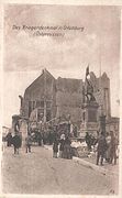
In the town of Ortelsburg, which was destroyed in 1914, the war memorial was preserved in 1870/71.
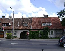
Houses in Szczytno 2009

City hall at night
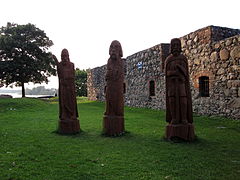
Ruin of the Ordensburg
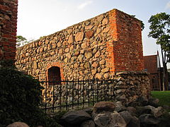
Ruins of the order castle

Floor plan of the former order castle


.jpg)
.jpg)

Population numbers
| year | Check- residents |
Remarks |
|---|---|---|
| 1782 | over 1,000 | in 131 households, not including the garrison consisting of a squadron of hussars |
| 1831 | 1,477 | half Polish and half German population |
| 1875 | 1,980 | |
| 1880 | 2.146 | |
| 1890 | 2,858 | 195 Catholics and 159 Jews (700 Poles ) |
| 1905 | 5,079 | with the garrison (a hunter battalion No. 1 and a machine gun division No. 1), mostly Evangelicals |
| 1925 | 10,357 | of which 9,031 Protestants, 1,019 Catholics, twelve other Christians and 145 Jews |
| 1933 | 12,251 | thereof 10,790 Evangelicals, 1,201 Catholics, no other Christians and 112 Jews |
| 1939 | 13,523 | thereof 11,424 Evangelicals, 1,398 Catholics, 254 other Christians and 27 Jews |
| 2012 | 25,030 |
Religions
Christianity
A Christian church was founded in Ortelsburg as early as the time of the order and manifested in a church building in 1483. With the introduction of the Reformation in East Prussia , the Evangelical Lutheran doctrine established itself here . The Roman Catholic denomination has been predominant in the city since 1945 .
Protestant church
.jpg)
The Protestant church building was built from 1717 to 1719 on the foundations of the former religious order. It is a plastered building with an exposed west tower. The baroque altar from 1719 probably comes from a workshop in Danzig , as does the pulpit made at the same time . Today's organ replaces a factory of the Terletzki organ building workshop . After a fire on October 10, 1970, the church was renovated between 1972 and 1973.
1939 was one parish alone in the city area 11,424 church members, to which must be in the parish places were added. Until 1945 the parish was assigned to the superintendent district Ortelsburg of the parish of Ortelsburg in the church province of East Prussia of the Church of the Old Prussian Union . At that time, three clergymen were serving here at the same time. Today Szczytno is again its own parish. With its branch church in Rańsk, it is part of the Masurian diocese of the Evangelical-Augsburg Church in Poland . The Protestant church has its own cemetery, which existed before 1945.
Ortelsburg was the seat and namesake of a church district from 1818 to 1945 . Most recently it was divided into two superintendent districts, into which a total of 16 parishes were incorporated:
-
Ortelsburg superintendent district
-
Flammberg
(until 1904: Opalenietz) - Friedrichshof
- Fürstenwalde
- Gawrzialken (1928–1945: Wilhelmsthal)
- Great shiemans
- Lipowitz (1933–1945: Lindenort)
- Ortelsburg
- Willenberg
-
Flammberg
-
Passenheim superintendent district
- Groß Schondamerau
- Klein Jerutten - Schwentainen (1938–1945: Altkirchen)
- Kobulten
- Mensguth
- Passenheim
- Dolls
- Rhine wine
- Theerwisch - Jablonken (1938–1945: Wildenau)
Roman Catholic Church

Today there are five Catholic church buildings in the city of Szczytno :
The parish church "Assumption of Mary" ( Polish Wniebowzięcia Najświętszej Maryi Panny ) in the district of Beutnerdorf was built from 1898 to 1899 in neo-Gothic style. The church has a remarkable interior painting and neo-Gothic furnishings from the time it was built.

The parish church "Stanislaus Kostka" ( Polish Św. Stanisław Kostka ) dates from the years 1929 to 1931 and was before 1945 the church of the New Apostolic congregation .
The three other churches ("Christ the King", "Heiligkreuz" and "Brother Albert") date from the 20th century.
Until 1945 there was only the parish of the Assumption of Mary, to which in 1939 there were 1,398 parishioners in the city area alone in addition to those in the widespread parish district. The was assigned to the deanery Masuria I based in Angerburg (Polish : Węgorzewo ) in the then diocese of Warmia . Today the five parishes belong to the Deanery Szczytno.
In the deanery Szczytno eight parishes are involved. There are the five city parishes as well as the country parishes Opaleniec (Flammberg , until 1904 Opalenietz) , Szymany (Groß Schiemanen) and Wielbark (Willenberg) .
Baptists

The chapel of the free church of the Bapstists dates from 1903 . Before 1945 it had about 500 believers. Even today the chapel is once again the place of worship for the Baptists who have formed the Christian Baptist Union in the Polish Republic .
Judaism

In 1939, 27 Jews were registered in the town of Ortelsburg. There was a Jewish prayer house in the city as early as 1835. In 1924 it was replaced by a new synagogue . There is no information about their existence, not even about Jewish life today. The still existing Jewish cemetery keeps the memory of Jewish life before 1945 alive. It was created in 1815 and is considered the best preserved Jewish cemetery in Warmia and Mazury.
politics
Borough
The city of Szczytno forms an independent municipality (gmina miejska) . On June 30, 2019, it had 23,267 inhabitants.
Rural community
The rural community of Szczytno, to which the town itself does not belong, has an area of 346.2 km². On June 30, 2019, it had 13,040 inhabitants.
coat of arms
Blazon : "In silver on green ground, a red stag leaping out of the green forest to the left."
The community only received city rights in 1616. A court seal dated 1667 first shows the above coat of arms, which is then also used in DER KONIGL. PR. STATD ORTELSBVRG MAGISTRATSSIEGEL stands.
Town twinning
Since October 8, 1991, the German city of Herne has been sponsoring Szczytno. A partnership with the German city of Herten has existed since 2008 .
sons and daughters of the town
sorted by year of birth
- Gustav von Fabeck (1813–1889), Prussian lieutenant general
- Eugen Hahn (1841–1902), surgeon
- Friedrich "Fritz" Freiherr von Massenbach (1861–1915), Prussian district administrator
- Julie Salinger (1863–1942), Saxon politician
- Alfred Flakowski (1872–1942), businessman
- Max Paul Neumann (1874–1937), agricultural scientist
- Hans Jürgen von der Wense (1894–1966), writer, translator and composer
- Horst Kopkow (1910–1996), secret service officer and Gestapo officer
- Ingeborg Kelch-Nolde (1914–1997), librarian and journalist
- Rosemarie Rehahn (1923–2010), film critic
- Hansjoachim Linde (1926–2020), doctor and chief staff officer
- Richard Anders (1928–2012), writer
- Gerhard Scheumann (1930–1998), film director
- Christine Laszar (* 1931), actress
- Werner Sumowski (1931–2015), art historian
- Klaus Kilimann (* 1938), politician
- Waldemar Kobus (* 1966), actor
- Sigrid Nikutta (* 1969), Manager (BVG, DB)
Honorary citizen
- Otto Czygan (1814–1897), pastor at the Protestant church Ortelsburg / Szczytno from 1848 to 1853, and from 1859 to 1888 at the Protestant church Nikolaiken / Mikołajki
- Otto von Bismarck (1815–1898), politician and statesman
traffic
Numerous traffic routes meet here. The three national roads 53 ( Olsztyn - Ostrołęka ), 57 ( Bartoszyce - Pułtusk ) and 58 ( Olsztynek - Grajewo ) cross. The Olsztyn – Ełk and the Biskupiec – Ostrołęka railway meet , although the latter has not been used since 1992/2002.
The international airport "Mazury" Szczytno-Szymany (Groß Schiemanen) is ten kilometers south of the city .
literature
- Johann Friedrich Goldbeck : Complete topography of the Kingdom of Prussia . Part I: Topography of East Prussia . Königsberg / Leipzig 1785, p. 28.
- August Eduard Preuss : Prussian country and folklore . Königsberg 1835, p. 458, no.71.
- Max Toeppen : About Prussian Lischken, towns and cities. A contribution to the history of the municipal constitutions in Prussia . In: Old Prussian Monthly Journal , Volume 4. Königsberg 1867, pp. 621–646, especially pp. 621–633.
- Max Toeppen : History of Masuria - A contribution to the Prussian state and cultural history. 1870 (540 pages); Reprinted 1979, pp. 92-98.
- Daniel Heinrich Arnoldt : Brief messages from all preachers who have been admitted to the Lutheran Churches in East Prussia since the Reformation . Königsberg 1777, pp. 454-455.
- H. Gollub: History of the city of Ortelsburg. 1926. Reprinted in 1993, ISBN 3-7921-0522-5 .
- Andreas Kossert : Masuria. East Prussia's forgotten south. Pantheon, Munich 2006, ISBN 3-570-55006-0 .
- Max Meyhöfer: The Ortelsburg district. An East Prussian homeland book. Leer 1978.
- Max Meyhöfer: The rural communities of the Ortelsburg district. Leer 1984.
- Max Meyhöfer: The rural communities of the Ortelsburg district (supplementary volume). Leer 1971.
- Max Brenk: The Ortelsburg district in the picture. Leer n.d., ISBN 3-7921-0259-5 .
- Burkhard Wittek: Masuria - My place. Nowhere. Report of my trip to a province of forgotten memory. 2nd Edition. Wiesenburg-Verlag, Schweinfurt 2011, ISBN 978-3-940756-37-4 .
Web links
- Literature by and about Szczytno in the catalog of the German National Library
- Website of the city of Szczytno
Individual evidence
- ↑ a b population. Size and Structure by Territorial Division. As of June 30, 2019. Główny Urząd Statystyczny (GUS) (PDF files; 0.99 MiB), accessed December 24, 2019 .
- ↑ a b c Jan Salm: East Prussian cities in the First World War. Reconstruction and reinvention. Oldenbourg Wissenschaftsverlag , 2012, ISBN 978-3-486-71209-4 , p. 168 ff
- ↑ nid.pl (Polish)
- ↑ Herbert Marzian , Csaba Kenez : self-determination for East Germany. Documentation on the 50th anniversary of the East and West Prussian referendum on July 11, 1920. Ed .: Göttinger Arbeitskreis , 1970, p. 97.
- ^ Johann Friedrich Goldbeck : Complete topography of the Kingdom of Prussia . Part I: Topography of East Prussia . Marienwerder 1785, p. 28.
- ^ August Eduard Preuss : Prussian country and folklore . Königsberg 1835, p. 458, no.71.
- ^ A b c d e f Michael Rademacher: German administrative history from the unification of the empire in 1871 to the reunification in 1990. East Prussia: Ortelsburg district. (Online material for the dissertation, Osnabrück 2006).
- ^ Meyer's Large Conversational Lexicon . 6th edition, Volume 15, Leipzig and Vienna 1908, p. 143.
- ↑ a b churches in Ortelsburg at ostpreussen.net
- ↑ Walther Hubatsch , History of the Protestant Church in East Prussia , Volume 2, Pictures of the East Prussian Church , Göttingen 1968, p. 129, Fig. 603–604
- ↑ Walther Hubatsch, History of the Evangelical Church of East Prussia , Volume 3 Documents , Göttingen 1968, p. 496
- ↑ Michael Rademacher, local register, city / district Ortelsburg
- ↑ see: Andreas Kossert : The Jewish community in Ortelsburg , in: Michael Brocke , Margret Heitmann , Harald Lordick (eds.): On the history and culture of the Jews in East and West Prussia . Hildesheim: Olms, 2000, pp. 87-124
- ↑ Erich Keyser : German city book - manual urban history, Volume I: Northeast Germany. W. Kohlhammer Verlag, Stuttgart 1939, pp. 90-91.
- ^ Otto Hupp : German coat of arms . Kaffee-Handels-Aktiengesellschaft , Bremen 1925.
- ↑ Homepage of the city of Herne: Sponsorships. Retrieved April 22, 2017 .