Černá v Pošumaví
| Černá v Pošumaví | ||||
|---|---|---|---|---|
|
||||
| Basic data | ||||
| State : |
|
|||
| Region : | Jihočeský kraj | |||
| District : | Český Krumlov | |||
| Area : | 5047 ha | |||
| Geographic location : | 48 ° 44 ' N , 14 ° 7' E | |||
| Height: | 728 m nm | |||
| Residents : | 849 (Jan. 1, 2019) | |||
| Postal code : | 382 22 - 382 26 | |||
| License plate : | C. | |||
| traffic | ||||
| Street: | Český Krumlov - Horní Planá | |||
| Railway connection: | České Budějovice – Černý Kříž | |||
| structure | ||||
| Status: | local community | |||
| Districts: | 6th | |||
| administration | ||||
| Mayor : | Irena Pekárková (as of 2018) | |||
| Address: | Černá v Pošumaví 46 382 23 Černá v Pošumaví |
|||
| Municipality number: | 545457 | |||
| Website : | www.cernavposumavi.cz | |||
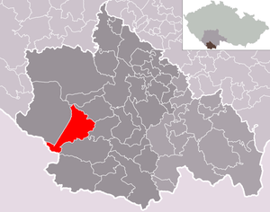
| Location of Černá v Pošumaví in the Český Krumlov district | ||||

|
||||
Černá v Pošumaví (German Schwarzbach ) is a municipality in the Czech Republic . It is located seven kilometers southeast of Horní Planá in the Bohemian Forest and belongs to the Okres Český Krumlov . The cadastral area is 5039 ha.
geography
The place is located in 728 m nm on both sides of the Černý potok (Schwarzbach) on the eastern bank of the Lipno reservoir at the entrance to the Olšina Bay. To the northwest, the bridge on State Road 39 leads from Hořice na Šumavě to Horní Planá across the bay, on the opposite bank of which is the train station Černá v Pošumaví on the Český Krumlov - Volary line . Černá v Pošumaví is the starting point of state road 163, which leads south towards Frymburk nad Vltavou . At Dolní Vltavice there is a ferry connection to the desert of Kyselov on the western bank of the reservoir in the summer months.
Neighboring towns are Mokrá in the northeast, Muckov in the east, Plánička in the southeast, Bližná in the southwest and Hůrka and Žlábek in the northwest.
Community structure
The municipality Černá v Pošumaví consists of the districts
- Bližná ( Eggetschlag ) ⊙ ,
- Černá v Pošumaví ⊙
- Dolní Vltavice ( Unterwuldau , from 1918: Untermoldau ) ⊙ ,
- Mokrá ( Mugrau ) ⊙ ,
- Muckov ( Mutzgern ) ⊙ and
- Plánička ( Planles ) ⊙ .
The hut colonies also belong to Černá v Pošumaví
as well as the hamlets, layers and holiday settlements
- Bednáře ( Emmern ) ⊙ ,
- Hostínova Lhota ( Hossenschlag ) ⊙ (250 m southeast of the settlement area, west of a 836 m nm high mountain is the Hauer H. [H. probably for house or yard] ⊙ ),
- Jámy ( cabbage pits ) ⊙ ,
- Lesní Domky (also: Plánička hájenka or Plánička - Lesní Domky) ( forest houses ) ⊙ ,
- Rybáře ( fish bakers ) ⊙ ,
- Slavkovice ( slagging ) ⊙ ,
- U Baštýře ⊙ and
- Ořechovka ⊙ .
In the municipality, there are also the desert areas on the south-west bank of the Lipno lake near the Austrian border
- Kyselov ( Sarau ) ⊙ and
- Kozí Stráň ( Geißleiten ) ⊙ about 400 m east-southeast of the 769 m high mountain Kozí stráň ⊙ .
Other abandoned places include a. Kramolín ( Gromling ) ⊙ , Nová Lhota ( Neustift ) ⊙ , Hubenov (Hubene) ⊙ and the Faschingův dvůr (Fasching Hof) ⊙ .
Basic settlement units are Bližná, Černá v Pošumaví, Dolní Vltavice, Kyselov, Mokrá, Muckov and Plánička.
The train station (Czech nádraží ) "Černá v Pošumaví" of the Czech Railways ( ČD ) is located in the village of Hůrka (German Stuben ) in the municipality of Horní Planá (German Ober Plan ), about 900 m southeast of Stará Hůrka (ie "Alt" -Hůrka) and about 400 m west-northwest of the former graphite mine. Map with all coordinates of the community structure section : OSM .![]()
The municipality is divided into the cadastral districts of Černá v Pošumaví and Kyselov.
Neighboring communities
| Polná na Šumavě | Hořice na Šumavě | |
| Horní Planá |

|
|
| Aigen-Schlägl | Frymburk nad Vltavou | Světlík |
history
The first written mention of the village took place on March 27, 1268 under the name Na tscherne rece ( Na černé řece / At the black stream ) in a Latin deed of donation from Hirz von Klingenberg to the Goldenkron monastery . Hirz came from the Rhineland and is known in Czech as Hrz ze Zvíkova . From around 1250 he was burgrave of Klingenberg (Zvíkov) and died on March 13, 1275.
The place was subordinate to the farm yard of the Goldenkron monastery in Mugrau ( Mokrá ). After the destruction of the monastery by the Hussites in 1420, Ulrich II von Rosenberg appropriated the place and incorporated it into the Krummau rule . The seat of the lower jurisdiction was Unterwuldau ( Dolní Vltavice ). In Urbar in 1445 is Szwarczpach . Subsequently, the name Czerna occurs for the place; from 1502 (until 1945) only Schwarzbach in various spellings. Schwarzbach had a judge since 1510 and in 1585 the place received its own lower jurisdiction. A chateau was built in the village and in 1568 Jakob Krčín of Jelčany built the chateau brewery and mill next to it. An old trade route ran through Schwarzbach, connecting Krummau with Aigen and Passau .
In the second half of the 18th century, graphite bearings were discovered near Schwarzbach and Stuben ( Hůrka ) . The inhabitants dug for the black mineral to use as a lubricant or blackening agent. In 1767 Schwarzbach graphite became known in Prague and a little later in Vienna and neighboring Bavaria. Due after the increased interest and advanced uses of Joseph Hardtmuth 1790 a process for the manufacture of pencil leads had developed from graphite, the mineral was in 1811 the bergregal subordinated and Joseph Prince of Schwarzenberg unsuspected graphite camp in his reign and began the following year with the mining Dismantling. The buyer of the raw material was Hardtmuth, whose company relocated its headquarters from Vienna to Budweis and became world-famous with the Koh-i-Noor Hardtmuth brand . Pencils were also made from graphite by Schwarzbach and Stuben in the nearby Goldenkron . In addition, the graphite works exported the mineral to many countries. In 1841 there were 341 inhabitants in Schwarzbach. Until the replacement of patrimonial Schwarzbach remained subordinate to Krummau and became an independent municipality in 1850. The Schwarzbach-Stuben train station was built at the graphite mine on the right-hand side of the Olschbach. Other pits were at Eggetschlag ( Bližná ) and Mugrau ( Mokrá ). By 1870, graphite mining in the area employed around 1,000 miners. After a price drop, graphite mining was stopped in 1930 and the Schwarzenberg mining operations were dissolved in 1942. After the nationalization of mining in 1948, the "Václav" mine in Bližná was reopened. The mining of Černá and Hůrka was not resumed. When the dam on the Vltava River began in 1952, the Olšina ( Olschbach ) valley was also flooded in 1959 . Černá, whose largest body of water until then was the small brook Černý potok ( Schwarzbach ), which flowed into the Olšina northwest of the village, has since transformed into a resort where campsites and holiday accommodations have been built.
Today the place Černá v Pošumaví, which lies at the ten kilometers widest point of the Lipno reservoir, is a water sports center of the lake.
Population development
| year | total | Men | Women | Bližná | Černá | Dolní Vltavice | Mokrá | Muckov | Plánička |
|---|---|---|---|---|---|---|---|---|---|
| 1869 | 2,029 | k. A. | k. A. | 261 | 378 | 540 | 433 | 202 | 215 |
| 1900 | 2,507 | k. A. | k. A. | 359 | 529 | 692 | 511 | 203 | 213 |
| 1930 | 2,442 | k. A. | k. A. | 364 | 533 | 670 | 451 | 194 | 230 |
| 1950 | 711 | k. A. | k. A. | 91 | 268 | 68 | 138 | 75 | 71 |
| 1961 | 750 | 400 | 350 | 120 | 367 | 31 | 85 | 79 | 68 |
| 1970 | 845 | 431 | 414 | 124 | 486 | 39 | 63 | 92 | 41 |
| 1980 | 807 | 419 | 388 | 93 | 561 | 23 | 41 | 69 | 20th |
| 1990 | 796 | 413 | 383 | 100 | 582 | 18th | 26th | 55 | 15th |
Attractions
- Church of the Immaculate Conception of the Virgin Mary - Černá v Pošumaví ⊙ , built in 1799–1800 in place of a previous wooden building from 1787 and redesigned between 1901 and 1904 in neo-Romanesque style and provided with a tower;
- Statue of St. Johannes Nepomuk ;
- Chapel near Dolní Vltavice;
- Chapel of torture pillar.
nature
Large parts of the municipality of Černá v Pošumaví are today in the Šumava Biosphere Reserve and are characterized by a very species-rich nature.
Web links
- Website of the municipality on cernavposumavi.cz.
- Historical information about the community on bwb-ooe.at.
- Černá v Pošumaví . In: Online encyclopedia encyklopedie.ckrumlov.cz about Krummau .
Individual evidence
- ↑ http://www.uir.cz/obec/545457/Cerna-v-Posumavi
- ↑ Český statistický úřad - The population of the Czech municipalities as of January 1, 2019 (PDF; 0.8 MiB)
- ↑ http://www.uir.cz/casti-obce-obec/545457/Obec-Cerna-v-Posumavi
- ↑ a b c d e f g Černá v Pošumaví . In: Online encyclopedia encyklopedie.ckrumlov.cz about Krummau (German, XHTML).
- ↑ a b c d e map viewer masrozkvet.cz , mapy.cz and mapy.ckrumlov.cz , also with land map in masrozkvet.cz and historical map in masrozkvet.cz and mapy.cz , as well as both combined in masrozkvet.cz . Accessed and received on February 17, 2016.
- ↑ http://www.uir.cz/zsj-obec/545457/Obec-Cerna-v-Posumavi
- ^ Horní Planá . In: Online encyclopedia encyklopedie.ckrumlov.cz about Krummau (German, XHTML).
- ↑ http://www.uir.cz/katastralni-uzemi-obec/545457/Obec-Cerna-v-Posumavi
- ↑ a b History of trochu podrobněji on cernavposumavi.cz.
- ↑ http://www.historie.hranet.cz/heraldika/pdf/cmh2-251-278.pdf , p. 274.
- ↑ https://www.hrad-zvikov.cz/cs/o-hradu/historie
- ↑ Henry Reininger: Majetky kláštera zlatokorunského , online kohoutikriz.org (Czech).
- ↑ Urbar 1445, currently in the SOA Cesky Krumlov.
- ↑ Schwarzbach on bwb-ooe.at.
- ^ History of mining in the town of Český Krumlov . In: Online encyclopedia encyklopedie.ckrumlov.cz about Krummau .


