
Seeberg BE
| BE is the abbreviation for the canton of Bern in Switzerland and is used to avoid confusion with other entries in the name Seeberg . |
| Seeberg | |
|---|---|
 |
|
| State : |
|
| Canton : |
|
| Administrative district : | Oberaargau |
| BFS no. : | 0988 |
| Postal code : | 3365 Seeberg 3475 Hermiswil |
| Coordinates : | 617 146 / 222695 |
| Height : | 495 m above sea level M. |
| Height range : | 464–809 m above sea level M. |
| Area : | 16.80 km² |
| Residents: | 1560 (December 31, 2018) |
| Population density : | 93 inhabitants per km² |
| Website: | www.seeberg.ch |
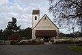
 Seeberg Reformed Church |
|
| Location of the municipality | |
  |
|
Seeberg is a municipality in the Oberaargau administrative district in the canton of Bern in Switzerland .
geography
Seeberg lies at 495 m above sea level. M. , 5 km southwest of Herzogenbuchsee and 11 km north of the city of Burgdorf (linear distance). The village extends in the broad basin of the Dorfbach, embedded between the heights of Chräjenberg and Berg , on the edge of the Molasse hill country east of the Emme alluvial plain , in Oberaargau .
The area of the 15.8 km² municipal area covers a section of the Bernese Mittelland with a great variety of landscapes. During the high stage of the Würm Ice Age, the area was on the edge of the Rhone Glacier . The larger western part of the municipality is characterized by the rounded molasse hills of Grossholz ( 603 m above sea level ), Steinenberg ( 634 m above sea level ), Steinhof (up to 595 m above sea level ) and Berg ( 543 m above sea level). ). These hills are separated from each other by 200 m to 600 m wide, flat valley depressions with no actual running water. In the Steinenberg forest in particular, numerous boulders made of gneiss , such as those found in the Valais Alps , bear witness to the advance of the Ice Age glacier.
The north-western part of the municipality includes the plain near the Seeberg settlement and extends to the Burgäschisee , the southern part of which belongs to Seeberg.
The valley of the Önz , which crosses the municipality from south to north, with the up to 500 m wide flat valley floor formed a meltwater channel for the Aare and Emme at the edge of the Rhone glacier for a long time during the Würme Ice Age . The southeastern part of the municipality is located in the hilly landscape of the Buchsiberge (between Önz and Langete ) with steep, mostly wooded slopes and valley valleys , characteristic landscapes for areas that were not covered by ice during the last ice age. In a narrow corner, the municipality extends to the southeast and includes the eastern flank of the Mutzbach valley with the short side valleys and the heights of Heidetewald ( 662 m above sea level ), Lindenberg (at 810 m above sea level, the highest elevation of Seeberg) and Eggstutzwald ( 808 m above sea level ).
In 1997, 7% of the municipal area was settled, 34% forest and woodland, 58% agriculture and a little less than 1% was unproductive land.
Numerous hamlets, farm settlements and individual farms belong to Seeberg. The important ones include:
- Grasswil, consisting of Niedergrasswil ( 511 m above sea level ) and Obergrasswil ( 515 m above sea level ) in the valley between Grossholz and Steinenberg
- Spiegelberg ( 511 m above sea level ) in the valley between Grossholz and Steinenberg
- Bittwil ( 544 m above sea level ) in a valley on the eastern slope of the large wood
- Rain heaps ( 501 m above sea level ) in the valley between the height of Steinhof and the Steinenberg
- Riedtwil ( 498 m above sea level ) in the Önztal at the confluence of the Mutzbach and the Önz between Steinenberg and Guldisbergwald
- Oschwand ( 626 m above sea level ) on a saddle in the Buchsibergen east of the Heidetewald; only the houses to the west of Dorfstrasse belong to Seeberg
- Hole ( 613 m above sea level ) in the Buchsibergen on a terrace east of the Mutzbach valley
- Juchten ( 687 m above sea level ) on the western slope of the Lindenberg above the Mutzbachtal
- Hermiswil ( 502 m above sea level ) in the Önztal northeast of the Steinenberg, incorporated as of January 1, 2016
Seeberg's neighboring communities are Herzogenbuchsee , Ochlenberg , Bettenhausen , Wynigen , Alchenstorf and Hellsau in the canton of Bern and Drei Höfe and Aeschi in the canton of Solothurn .
population
With 1560 inhabitants (as of December 31, 2018) Seeberg is one of the smaller communities in the canton of Bern. 97.5% of the residents are German-speaking, 0.7% Turkish-speaking and 0.5% speak French (as of 2000). The population of Seeberg was 1954 inhabitants in 1850 and 1722 inhabitants in 1900. In the course of the 20th century the population decreased by a further 30% to 1224 people due to strong emigration until 1980. Since then there has been a slight increase in population again.
politics
The voting shares of the parties in the 2015 National Council election were: SVP 39.8%, BDP 25.1%, SP 11.2%, glp 5.7%, GPS 4.4%, EDU 4.1%, FDP 3.7 %, EVP 2.6%, SD 1.2%, CVP 1.0%.
economy
Until the second half of the 20th century, Seeberg was a village dominated by agriculture . Even today, agriculture and fruit growing as well as cattle and dairy farming have an important place in the income structure of the population. Further jobs are available in local small businesses and in the service sector. In Seeberg today there are companies in the building trade, the electrical industry, horticulture, wood processing, IT, mechanical engineering as well as garages and mechanical workshops.
In the last few decades the village has developed into a residential community with the construction of new quarters, especially in the Seeberg and Grasswil area. Many employed people are therefore commuters who work mainly in the Langenthal - Herzogenbuchsee , Burgdorf and Solothurn regions.
traffic
The community is very well developed in terms of transport. It is located on Hauptstrasse 1 from Bern to Zurich . Seeberg, Grasswil and Riedtwil are connected to the public transport network by a bus line that runs from Herzogenbuchsee to Wynigen . The railway line from Herzogenbuchsee to Bern, which ran through the Önztal and was inaugurated on June 12, 1857, had a stop in Riedtwil until 1998.
history

Important Stone Age lakeside settlements are known from the Burgäschisee.
The municipality of Seeberg was also settled during Roman times, which has been proven by excavations of Roman wall foundations on the church hill. The place was first mentioned in a document in 1076 under its current name. The names Seberch (1264) and Zeberch (1301) appeared later . The place name goes back to the Old High German word seo (lake). It means mountain by the lake , probably because of the proximity to the Burgäschisee.
Seeberg, together with Grasswil and Riedtwil, had been under the rule of the Kyburgers since the Middle Ages and was in the Gutisberg district. The church of Seeberg belonged to the Lords of Wolhusen in the 11th century and then to the monastery of St. Peter in the Black Forest. Grasswil was sold to a Solothurn family in 1370 , but after pressure from Bern in 1395 it was transferred to the city of Burgdorf, which appointed a bailiff in Grasswil. Seeberg and Riedtwil also came under the sovereignty of the city of Bern in 1406 and were assigned to the Bailiwick of Wangen. After the collapse of the Ancien Régime (1798), Seeberg belonged to the district of Wangen during the Helvetic Republic and from 1803 to the Oberamt Wangen, which received the status of an official district with the new cantonal constitution of 1831.
On January 1, 2016, the previously independent communities of Hermiswil and Seeberg merged.
Attractions
The church hill was already settled in Roman times. In 2000 the remains of the wall of a Roman manor were found. Later a cemetery was built on the site, on which a small wooden church building was first built. This explains the location of the church outside the village, on the so-called "mountain". Various stone church buildings were detached until the late Gothic church of Saint Martin with a tower was built in 1516 . A church that was mentioned as early as the 11th century is probably a daughter church of the Herzogenbuchsee Provost. The country-style rectory dates from 1781.
In Seeberg and in the various hamlets there are numerous characteristic farmhouses from the 17th to 19th centuries.
The natural monuments in the municipal area include the Burgäschisee, the Erratische Blocks on the Steinenberg and the Mutzbach waterfall.
photos
church

Interior of the church

Rectory

Half-timbered house in Seeberg

Seeberg schoolhouse
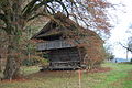
Holzstadel in Seeberg
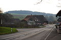
Main street No. 1 in Seeberg


_236.JPG)
_249.JPG)

_208.JPG)
_209.JPG)
Personalities
- Cuno Amiet (1868–1961), Swiss painter, lived for 60 years in the hamlet of Oschwand in the Seeberg community.
- Lina Bögli (1858–1941), writer
- Ludwig Schläfli (1814–1895), Swiss mathematician
Web links
- Official website of the Seeberg community
- Anne-Marie Dubler : Grasswil. In: Historical Lexicon of Switzerland .
- Anne-Marie Dubler : Riedtwil. In: Historical Lexicon of Switzerland .
- Anne-Marie Dubler: Seeberg. In: Historical Lexicon of Switzerland .
- Seeberg Church
- Seeberg Parish Church Literature (PDF)
Individual evidence
- ↑ Permanent resident population from STAT-TAB of the BfS , municipalities see also regional portraits 2020 on bfs.admin.ch, accessed on May 29, 2020
- ↑ Results of the Seeberg community. State Chancellery of the Canton of Bern, October 18, 2015, accessed on April 19, 2016 .
- ^ Peter Eggenberger: Seeberg, parish church. The results of building research from 1999/2000 . Bern 2009.
Aarwangen | Attiswil | Exit | Bannwil | Berken | Bettenhausen | Bleienbach | Busswil near Melchnau | Eriswil | Farners | Gondiswil | Dig | Heimenhausen | Herzogenbuchsee | Huttwil | Inkwil | Langenthal | Lotzwil | Madiswil | Melchnau | Niederbipp | Niederönz | Oberbipp | Top stake | Ochlenberg | Oeschenbach | Reisiswil | Roggwil | Rohrbach | Rohrbachgraben | Rumisberg | Rütschelen | Black Houses | Seeberg | Foolish | Thunstetten | Ursenbach | Walliswil near Niederbipp | Walliswil near Wangen | Walterswil | Wangen an der Aare | Wangenried | Wiedlisbach | Wynau | Wyssachen
Former municipalities: Bollodingen | Gutenburg | Hermiswil | Kleindietwil | Leimiswil | Oberönz | Röthenbach near Herzogenbuchsee | Shear | Undercut wood | Wanzwil | Wolfisberg
Canton of Bern | Administrative districts of the canton of Bern | Municipalities of the Canton of Bern