
Satkhira (District)
| Satkhira | |
|---|---|
 |
|
| Basic data | |
| Country | Bangladesh |
| division | Khulna |
| Seat | Satkhira |
| surface | 3,858.3 km² |
| ISO 3166-2 | BD-D |
Coordinates: 22 ° 21 ' N , 89 ° 5' E
Satkhira ( Bengali : সাতক্ষীরা জেলা , Sātakṣīrā jelā ) is an administrative district in southwestern Bangladesh , which lies within the Khulna division , the superordinate administrative unit. The capital in the northern part of the district is also called Satkhira . The district has 1,155,824 inhabitants (2011 census).
The 3858.33 km² district has Jessore to the neighboring district in the north , the Khulna district in the east, the Gulf of Bengal in the south and the Indian state of West Bengal on the west .
The most important rivers of the district, largely occupied by the Sundarbans , are the Kobadak , Sonai , Kholpatua , Morischap , Raimangal , Hariabhanga , Ichamati , Betrabati and Kalindi-Jamuna .
In 1861, Satkhira was first subordinated to Jessore before it was subordinated to Khulna in 1882. Since 1984 it has been an independent administrative district, which in turn is divided into the seven Upazilas Satkhira Sadar, Assasuni, Debhata, Kalaroa, Kaliganj, Shyamnagar and Tala. Within this administrative subdivision there are two self-governing cities ( municipalities ), 79 Union Parishads (village councils) and 1436 villages
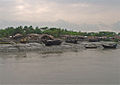
Fishing village in the Sundarbans in the Satkhira district

Rice planting near the village of Bhagbah


Individual evidence
- ↑ Bangladesh Bureau of statistics, 2011, names of the villages and population figures in Satkhira ( Memento of the original from November 13, 2015 in the Internet Archive ) Info: The archive link was automatically inserted and not yet checked. Please check the original and archive link according to the instructions and then remove this notice.
Web links
| Barishal |
Barguna • Barishal • Bhola • Jhalokathi • Patuakhali • Pirojpur |
|
| Chittagong |
Bandarban • Brahmanbaria • Chandpur • Chittagong • Cox's Bazaar • Feni • Khagrachhari • Kumilla • Lakshmipur • Noakhali • Rangamati |
|
| Dhaka |
Dhaka • Faridpur • Gazipur • Gopalganj • Kishoreganj • Madaripur • Manikganj • Munsiganj • Narayanganj • Narsingdi • Rajbari • Shariatpur • Tangail |
|
| Khulna |
Bagerhat • Chuadanga • Jessore • Jhinaidah • Khulna • Kushtia • Magura • Meherpur • Narail • Satkhira |
|
| Maimansingh |
Jamalpur • Maimansingh • Netrakona • Sherpur |
|
| Rajshahi |
Bogra • Jaipurhat • Naogaon • Natore • Nawabganj • Pabna • Rajshahi • Sirajganj |
|
| Rangpur |
Dinajpur • Gaibandha • Kurigram • Lalmonirhat • Nilphamari • Panchagarh • Rangpur • Thakurgaon |
|
| Sylhet |
Habiganj • Moulvibazar • Sunamganj • Sylhet |