
Ehrenkirchen
| coat of arms | Germany map | |
|---|---|---|

|
Coordinates: 47 ° 55 ' N , 7 ° 45' E |
|
| Basic data | ||
| State : | Baden-Württemberg | |
| Administrative region : | Freiburg | |
| County : | Breisgau-Upper Black Forest | |
| Height : | 265 m above sea level NHN | |
| Area : | 37.8 km 2 | |
| Residents: | 7379 (Dec. 31, 2018) | |
| Population density : | 195 inhabitants per km 2 | |
| Postal code : | 79238 | |
| Area code : | 07633 | |
| License plate : | FR | |
| Community key : | 08 3 15 131 | |
| LOCODE : | DE EHK | |
| Community structure: | 5 districts | |
| Address of the municipal administration: |
Jengerstrasse 6 79238 Ehrenkirchen, Germany |
|
| Website : | ||
| Mayor : | Thomas Breig | |
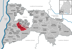
| Location of the municipality Ehrenkirchen in the district of Breisgau-Hochschwarzwald | ||
  |
||


Ehrenkirchen is a community around 13 kilometers south of Freiburg im Breisgau on the edge of the Markgräflerland in the Breisgau-Hochschwarzwald district .
geography
location
The community is located in the Upper Rhine Plain at an altitude of 215 to 916 meters and also includes the southern areas of the Batzenberg , Schneckental, Hohfirst and Hexental . The eastern parts of the district are mainly forested and are located in the Black Forest .
Community structure
Ehrenkirchen consists of the former communities of Ehrenstetten ( Alemannisch Ehrestette ) and Kirchhofen (alem. Chilchhofe ), which were united on April 1, 1973 . On January 1, 1974 Offnadingen (alem. Offnadige ), on April 1, 1974 Scherzingen (alem. Scherzige ) and on October 1, 1974 Norsingen (alem. Norschige ) was incorporated. The Ehrenstetten municipality within the borders of March 30, 1973 includes the village of Ehrenstetten, the hamlet of Gütighofen (alem. Güetighofe ) (partly also to Bollschweil ), the farms Felsenmühle, Kohlerhöfe and Lettenhof and the residential area Hintere Hattenmühle. The village of Kirchhofen and the hamlets of Oberambringen (alem. Oberambrige ) and Unteramringen (alem. Underambrige ) belong to the former municipality of Kirchhofen . At the beginning of the 21st century, the Niedermatten industrial area west of Unteramhaben was added as a new district. Only the villages of the same name belong to the former communities of Norsingen, Offnadingen and Scherzingen. In the district of Ehrenstetten are the abandoned villages Hartberg and Wolfsberg. In the Kirchhofen district are the abandoned villages of Edighofen, which may be identical to the abandoned Egishofen, as well as Seringen and Zeringgraben. In the district of Offnadingen, graves from the Merovingian period point to a lost village.
history
People lived in the “ devil's kitchen ” near Gütighofen as far back as the Stone Age . Amhaben, today part of Kirchhofen, was mentioned in a document in 855 or 861. Under the Vogtei Kirchhofen belonged together until the separation in 1843 Ehrenstetten, Kirchhofen, Ober- and Unteramringen. As part of the community reform in Baden-Württemberg , the two communities Ehrenstetten and Kirchhofen merged on April 1, 1973 to form the community of Ehrenkirchen. Offnadingen was incorporated on January 1, 1974, and Scherzingen was incorporated on April 1, 1974. Norsingen was incorporated on October 1, 1974.
History of Ehrenstetten

The caves of the reindeer hunters on the Mount of Olives near Gütighofen ("Devil's Kitchen") from the early Stone Age and the Alemanni graves on the edge of the Black Forest are evidence of early settlement. Ehrenstetten is first mentioned in a document in 1139. On August 10, 1418, Ehrenstetten was granted the right to hold a fair by Emperor Sigismund . In 1842 Ehrenstetten became independent as a municipality.
History of Kirchhofen

We find the first evidence of a settlement in Kirchhofen in the year 805. The Feimlisburg , which has been abandoned, is said to have been located nearby . The name Kirchhofen is mentioned for the first time in a document from 1087. As a place of pilgrimage and seat of the feudal lords , Kirchhofen was the focal point for a large number of surrounding places in the Middle Ages. A number of noble families of the Breisgau were successively feudal lords of the Kirchhofen rule.

In Castle Kirchhofen 1583 died the general, diplomat and imperial advisor Lazarus of Schwendi . Today the castle houses classrooms and apartments for asylum seekers as well as a small museum in memory of Schwendi, which is run by the castle association.
The relatively large regional importance of Kirchhofen during the Middle Ages can still be seen today in the generally much larger extension of the Kirchhofer district compared to the neighboring towns, which extends north in the Schneckental to just before Pfaffenweiler , in the west to the B3 just before Offnadingen and in the south to the bypass road and thus the border of the development of Bad Krozingen . In the Black Forest in the eastern Ehrenkirchen district there are also two large exclaves of the Kirchhofer Bann. On the Hohfirst it is the Kirchhofer and not the Ehrenstetter Bann, which extends to the Hohebannstein .
During the Thirty Years' War, Baden-Swedish troops under the command of the Rhine Count Otto Ludwig massacred on 18th and 19th centuries. June 1633 a large part of the male population of Kirchhofen. A total of around 300 farmers from Kirchhofen, Ehrenstetten and Pfaffenweiler were massacred as alleged rebels.
History of Norsingen

Alemannic foundations on the Batzenberg indicate an early settlement in Norsingen. The first documentary mention comes from the year 1242. Norsingen originally belonged to the monastery of St. Gallen , then came as a fief to the Lords of Staufen , after whose extinction (1602) the fief of St. Gallen was withdrawn. Together with Ehaben, where the St. Gallen governor had his seat, it fell to the Canton of St. Gallen in 1805 and was sold to the Grand Duchy of Baden in 1806/7 .
History of Offnadingen

The first customer of "Ofmanningen" comes from the year 1139. As early as 1146 a local nobility is attested here. In the Middle Ages, Offnadingen was one of the conference venues of the count's regional court in Breisgau.
Story Scherzingen

Blazon : "The coat of arms shows a split shield in front in red a golden chalice, behind in gold on green ground a green vine with blue grapes." The vine belongs to the older community seal, the chalice is intended to remind of the former belonging to the Staufen rule.
Alemannic grave finds also indicate an early settlement of Scherzingen. The first documented mention of Scherzingen comes from the year 1111. The place was then called Scersingen. A local nobility is attested in Scherzingen from 1111 to 1152. In the Middle Ages the village belonged to various noble families, such as the Staufen rule and the overlordship of the Üsenberger , the Margraves of Hachberg and the House of Austria as sovereigns of the Staufen rule. From 1492 to 1811 Scherzingen belonged to the Pfaffenweiler community.
Today Scherzingen consists mostly of old houses in the old French style, as the French fled and settled there when the French Revolution began. The village shop, which existed for about five years, burned down. The reasons for this have never been fully clarified. Scherzingen is divided into lower and upper village, which are separated by the continuous railway line . The old part is the Unterdorf, where there is also a church called St. Michael with a cemetery. There are around 250 residents in total.
religion

Independent Catholic parish since 1912, independent Protestant parish since 1979
politics
Municipal council

The municipal council consists of the elected voluntary councilors and the mayor as chairman. The mayor is entitled to vote in the municipal council.
The local council in Ehrenkirchen has 18 members. The local elections on May 26, 2019 led to the following official final result:
| Parties and constituencies | % 2019 |
Seats 2019 |
% 2014 |
Seats 2014 |
% 2009 |
Seats 2009 |
|||
|---|---|---|---|---|---|---|---|---|---|
| CDU | Christian Democratic Union of Germany | 31.17 | 6th | 37.73 | 6th | 38.2 | 6th | ||
| FW | Free voter association Ehrenkirchen | 32.06 | 6th | 32.20 | 6th | 33.1 | 6th | ||
| GREEN | Alliance 90 / The Greens | 25.18 | 4th | 15.10 | 3 | 15.6 | 3 | ||
| SPD | Social Democratic Party of Germany | 11.59 | 2 | 14.97 | 3 | 13.0 | 3 | ||
| total | 100 | 18th | 100 | 18th | 100 | 18th | |||
| voter turnout | 65.99% | 55.2% | 55.3% | ||||||
coat of arms
Blazon: "In a split shield in front in red over golden three-mountain a golden grape with golden leaf, behind in gold an upright blue stag." The coat of arms was awarded on March 21, 1977 by the district office of Breisgau-Hochschwarzwald.
In the agreement on the merger of Ehrenstetten and Kirchhofen it was determined that a new coat of arms should be created for the future municipality. Like the new name, which is composed of name elements from the two largest parts of the municipality, this coat of arms was also created by amalgamating the previous coats of arms. It combines parts of the municipal coats of arms of Ehrenstetten and Kirchhofen and in a broader sense also of Scherzingen and at the same time comes to a statement that summarizes an economic peculiarity, the geographical location and the history of the municipality: In all districts, on the slopes of Batzenberg, Kirchberg and Ölberg, which are symbolized by the Dreiberg, have been viticulture since ancient times. The stag, the coat of arms of the St. Blasien monastery , reminds us that the Kirchhofen rulership, to which Ehrenstetten also belonged, as well as Offnadingen and Scherzingen as part of the Staufen rulership were subordinate to the Black Forest monastery in the 18th century and also owned it in Norsingen. The colors of the picture and field of the monastery coat of arms (a golden stag in blue) were swapped to avoid a heraldic color offense when the two shield fields meet.
Town twinning
Ehrenkirchen is a member of the Lazarus-von-Schwendi-Städtebund, founded in 1986 .
Culture and sights
- St. George's Church in Ehrenstetten
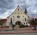
- Baroque pilgrimage church of St. Mary's Assumption in Kirchhofen
- Baroque parish church Heilig Kreuz from the 18th century and the building of the former monastery mill in Offnadingen
- Church of St. Michael in Scherzingen
- St. Gallus Church in Norsingen
- Kirchhofen moated castle
- Hohebannstein
- Alemanni graves near Ehrenstetten
- Wine cooperatives / wine tasting
- Various chapels in the district
- Johann Christian Wentzinger's birthplace in Ehrenstetten
- Stone Age path on the Mount of Olives with devil's kitchen

St. Mary's Assumption in Kirchhofen

Parish Church Heilig Kreuz Offnadingen
St. George's Church Ehrenstetten

St. Gallus Church Norsingen

Church of St. Michael Scherzingen

St. Fridolin's Chapel in Oberamhaben
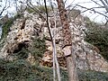
Devil's Kitchen


_jm4358.jpg)


.jpg)
Leisure and sports facilities

- Festival and sports halls: Kirchberghalle in the center; St. Gallushalle in Norsingen; Offnadingen parish hall
- Football pitches in Ehrenstetten and Kirchhofen.
- Tennis courts in Kirchhofen
- Skater facility with basketball facility
- Fitness path
Regular events
- Horse procession in honor of St. George (end of April / beginning of May) (Ehrenstetten)
- Laurentiusmarkt August 10 and Laurentiushock on the weekend before or after the Laurentiusmarkt (Ehrenstetten)
- Schlossgrabenhock on the last weekend in May (Kirchhofen)
- Church patronage Maria Himmelfahrt on August 15th (Kirchhofen)
- Fair and village festival in September (Offnadingen)
- Ehrenkirchener Woche, annual event of the Ehrenkirchen WVE trade association
- Open air in the Niedermatten with local bands, carried out by the Ehrenkirchen WVE trade association
- Batzenbergfest "Reloaded", carried out by the Ehrenkirchen WVE trade association in cooperation with winegrowers and winegrowers' cooperatives around the Batzenberg
Economy and Infrastructure
Educational institutions

- The Ehrenkirchen primary school with its locations in the districts of Kirchhofen and Ehrenstetten
- The Jenger secondary school with Werkrealschule in the Jenger center of Ehrenkirchen
- The Ecumenical Education Center Ehrenkirchen
- The library in the community center
Established businesses
The largest companies in Ehrenkirchen are Anton Hübner GmbH & Co. KG, a subsidiary of Dermapharm , which produces pharmaceuticals, medical products, dietary supplements and natural cosmetics in the Kirchhofen district with 100 employees, and Karl Dischinger GmbH, an international logistics service provider. In addition, there is a representative of the electrical industry, Fred Abel GmbH, in the Niedermatten industrial park, which represents renowned electrical industry companies from Germany. The company headquarters and the production facilities of the bakery chain Kaisers Gute Backstube , which is widespread in southern Baden , are also located in Ehrenkirchen. In 2016 there were 2,037 jobs subject to social security contributions in Ehrenkirchen, 100 more than in the previous year.
Ehrenkirchen volunteer fire department

As a result of the municipal reform in January 1976, the Ehrenkirchen volunteer fire brigade was established . This was an amalgamation of the district defense services of Kirchhofen, Ehrenstetten, Norsingen, Scherzingen and Offnadingen. The fire brigade has been operating a first responder service since 2017, which comes out in the event of medical emergencies and bridges the time until the rescue service arrives.
media
The Badische Zeitung and the advertising paper ReblandKurier report on local events in Ehrenkirchen .
traffic
The federal highway 3 and the Rheintalbahn with a stop for regional trains Offenburg - Basel run through the district Norsingen . The bus lines 7208 and 7240 of Südbadenbus GmbH connect Ehrenkirchen via the Schneckental and Hexental with Freiburg in the north and Bad Krozingen and Staufen in the south.
tourism
Ehrenkirchen is a member of the Zweckverband Breisgau Süd Touristik. In 2016 the community recorded 5246 overnight stays.
Since summer 2020 there have been three adventure trails in Ehrenkirchen : After the Stone Age Trail on the Mount of Olives and the mining trail in Ehrenstetter Grund, there is now also a 6.5-kilometer archeology trail that begins as a circular trail at the Schützenhaus in Ehrenstetten.
Trivia

On October 12, 2017, two related stamps appeared in the series “Germany's most beautiful panoramas”, which show the southern protrusion of the Ehrenstetter Mount of Olives with its chapel. The stamp was voted the most beautiful postage stamp in Germany and Europe in 2017.
Personalities
Honorary citizen
- Hermann Schäuble, manufacturer (Rheinische Transportanlagen GmbH)
Sons and daughters of the church
- Johann Christian Wentzinger (1710–1797), sculptor
- Johann Baptist Jenger (1793–1856), Austrian civil servant and musician
- Alfons Oswald (1903–1969), born in Norsingen, district administrator
Connected to the community
- Lazarus von Schwendi , baron of Hohenlandsberg (1522–1583), general, diplomat and imperial advisor, died in his castle in Kirchhofen.
- Konrad Guenther (1874–1955), zoologist
- Ekke Wolfgang Guenther (1907–1995), paleontologist, son of Konrad Guenther
Web links
- Official website
- Karl Heinz Burmeister: Norsingen. In: Historical Lexicon of Switzerland .
Individual evidence
- ↑ State Statistical Office Baden-Württemberg - Population by nationality and gender on December 31, 2018 (CSV file) ( help on this ).
- ^ The state of Baden-Württemberg. Official description by district and municipality. Volume IV: Freiburg District Kohlhammer, Stuttgart 1978, ISBN 3-17-007174-2 , pp. 80–84.
- ↑ StiASG , Urk. III 249 ( digital copy at e-chartae.ch ), accessed on June 12, 2020.
- ^ Federal Statistical Office (ed.): Historical municipality directory for the Federal Republic of Germany. Name, border and key number changes in municipalities, counties and administrative districts from May 27, 1970 to December 31, 1982 . W. Kohlhammer, Stuttgart / Mainz 1983, ISBN 3-17-003263-1 , p. 508 f .
- ↑ Kirchhofen - Altgemeinde ~ sub-town at leo-bw.de .
- ↑ Lorenz Werkmann: Kirchhofen in the year 1633. In: Schau-ins-Land , 1879, pp. 71–76 ( digitized version of the Freiburg University Library ).
- ↑ Ehrenkirchen, preliminary results of the municipal council election 2019 ( memento from May 29, 2019 in the Internet Archive ), accessed on November 12, 2019.
- ^ Mount of Olives Stone Age Path. erlebnispfade-ehrenkirchen.de, accessed on August 14, 2018 .
- ↑ Ehrenkirchen. muenstertal-staufen.de, accessed on December 25, 2017 .
- ↑ Andrea Gallien: A hiking trail gives insights into the world of the Celts and Alemanni. Badische Zeitung , July 18, 2020, accessed on July 19, 2020 .
- ↑ Tourism. Retrieved July 19, 2020 .
- ↑ Special stamps October 2017. bundesfinanzministerium.de , accessed on August 28, 2018 .
- ↑ Nikola Vogt: Ehrenkirchen represents Germany in the stamp competition. Badische Zeitung, March 12, 2019, accessed on March 13, 2019 .
- ↑ Local history working group Ehrenkirchen. Retrieved May 11, 2019 .