Bad Peterstal-Griesbach
| coat of arms | Germany map | |
|---|---|---|

|
Coordinates: 48 ° 26 ' N , 8 ° 14' E |
|
| Basic data | ||
| State : | Baden-Württemberg | |
| Administrative region : | Freiburg | |
| County : | Ortenau district | |
| Height : | 393 m above sea level NHN | |
| Area : | 41.24 km 2 | |
| Residents: | 2717 (Dec. 31, 2018) | |
| Population density : | 66 inhabitants per km 2 | |
| Postcodes : | 77740, 72250 | |
| Area code : | 07806 | |
| License plate : | OG, BH , KEL, LR, WOL | |
| Community key : | 08 3 17 008 | |
| LOCODE : | DE BPT | |
| Address of the municipal administration: |
Schwarzwaldstrasse 11 77740 Bad Peterstal-Griesbach |
|
| Website : | ||
| Mayor : | Meinrad Baumann | |
| Location of the municipality of Bad Peterstal-Griesbach in the Ortenau district | ||
Bad Peterstal-Griesbach is a municipality in the Ortenaukreis in Baden-Württemberg .
geography
Geographical location
Bad Peterstal-Griesbach is located at an altitude of 400 to 1000 meters in the upper Renchtal in the Baden Black Forest .
Community structure
Bad Peterstal-Griesbach consists of the formerly independent communities Bad Griesbach and Bad Peterstal (Renchtal). The municipality includes 51 villages, hamlets, Zinken, farms and houses.
Neighboring communities
The municipality borders in the north on Baiersbronn , in the east on Bad Rippoldsau-Schapbach , both in the Freudenstadt district , in the south on Oberwolfach , in the south-west on Oberharmersbach and in the west on the city of Oppenau .
In the Bad Griesbach part of the municipality were the village of Döttelbach, which was dissolved in Bad Griesbach, the villages of Herbstwasen and Hinterer Heidenbühl which were dissolved in Wilde Rench, Holzbühl which was dissolved in Breitenberg and the villages of Mühlbach and Wüstenbach.
The former municipality of Bad Griesbach is a place within the meaning of the Baden-Württemberg municipal code with its own local council and the mayor as its chairman.
history

Beginnings
The two places, which today form a municipality, belonged to the Archbishopric of Strasbourg from the end of the 14th century , where they were assigned to the rule of Oberkirch .
19th and 20th centuries
As part of the secularization due to the Reichsdeputationshauptschluss they fell in 1803 to the Electorate (1803-1806), the later Grand Duchy (from 1806) Baden , where they were assigned to the Offenburg District Office , which became the Offenburg district in 1939 . When this was dissolved in 1973, both communities came to the new Ortenaukreis . On July 1, 1973, the previously independent community of Bad Griesbach was incorporated into Bad Peterstal-Griesbach (renamed Bad Peterstal (Renchtal) ).
The baroque author Grimmelshausen , who temporarily lived in Renchen and Gaisbach in the Black Forest, let his character Simplicissimus stay for several years at a "Sauerbrunnen" in the Black Forest, which means Peterstal.
Population development
Population figures according to the respective area. The numbers are estimates, census results (¹) or official updates from the Baden-Württemberg State Statistical Office
|
|
Signing of the first Baden constitution
In 1818, Grand Duke Karl signed the first Baden constitution in what is now the Bad Griesbach district.
religion
There is a Catholic church in both districts. The formerly independent parishes now form the “Oberes Renchtal” pastoral care unit with Oppenau . There is a Protestant church in the Bad Peterstal district. The parish that belongs to it shares the parish with the neighboring parish of Oppenau.
politics
Municipal council
The municipal council in Bad Peterstal-Griesbach consists of 12 members and the mayor as chairman. The mayor is entitled to vote in the municipal council. The local elections on May 26, 2019 led to the following preliminary final result.
| Parties and constituencies |
% 2019 |
Seats 2019 |
% 2014 |
Seats 2014 |
||
| CDU | Christian Democratic Union of Germany | 41.6 | 5 | 43.1 | 5 | |
| SPD | Social Democratic Party of Germany | 20.6 | 3 | 28.6 | 3 | |
| FW | Free electoral association | 19.2 | 2 | 13.4 | 2 | |
| BV | Citizens Association | 18.6 | 2 | 15.0 | 2 | |
| total | 100.0 | 12 | 100.0 | 12 | ||
| voter turnout | 63.5% | 59.9% | ||||
mayor
- 1982–1990: Gerold Mayer
- 1990–1994: Otto Stecher
- 1994–2010: Johann Keller
- 2010 until today: Meinrad Baumann
coat of arms
Blazon: In blue, on a lowered green arched base of the gold-nimbed, silver-clad apostle Peter, in the hanging right hand a golden key with the beard turned downwards and outwards, the left hand raised, thumb and forefinger outstretched.
Culture and sights
Buildings
- Haberer tower. The 16 m high observation tower in the district of Bad Griesbach was built in 1899 in honor of Medical Councilor Albert Haberer (1828-1893), the sponsor of the Renchtal baths , on the 500 m southeast located 691.7 m above sea level. NHN high crosshead erected.
- Chapel of St. Anna
- Catholic parish church of St. Peter and Paul (Bad Peterstal district). The church was built in 1807 in the classical style. From 1923 to 1927 it was extensively expanded and rebuilt in the neoclassical style. The bell tower stands to the side of the nave, the main entrance is emphasized by columns and triangular gables; one of the best examples of churches in the style of neoclassicism in Baden-Württemberg. The altars come from the church of the former All Saints monastery .
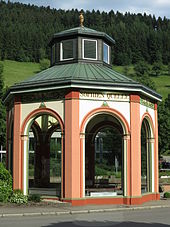
- Pavilion Bad Griesbach (place where the first Baden constitution was signed)
- Röschenschanze
- Key Bath Clinic
- Schwedenschanze (refuge)
- Sophienquelle
Green spaces and recreation
- Bad Griesbach spa gardens
- Bad Peterstal spa gardens
Natural monuments
- Klagstein
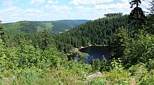
- Lake level nature reserve
- Devil's pulpit
Sports
- FIS Rollerski World Cup venue
- Summer ski jump (Bad Griesbach district)
- Sports field (district Bad Peterstal)
Regular events
- Big tattoo of the Bad Peterstal Citizen Militia Chapel
- Peter and Paul Festival, a patronage festival
- Summer night festival of the Bad Griesbach Music Association
Premium hiking resort
The German Hiking Institute eV certified Bad Peterstal-Griesbach in 2017 as the first premium hiking location in Germany. Bad Peterstal-Griesbach has three premium hiking trails :
- Wiesensteig
- Peterstaler Schwarzwaldsteig
- Himmelssteig
Economy and Infrastructure
Companies

- Bad Peterstal district
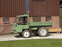
- MULAG vehicle factory Heinz Wössner GmbH u. Co. KG
- Peterstaler Mineralquellen GmbH
- TREYER PALETTEN GmbH
- Bad Griesbach district
- 5-star hotel Dollenberg
- Griesbacher Mineral- und Heilquellen GmbH
- Schwarzwald-Sprudel GmbH
- Former companies
- Ernst Platten & Sons KG (1950–2002), vehicles of the Platten brand
- Freyersbacher Schwarzwaldquellen GmbH & Co. KG (until 2013)
education
In Bad Peterstal there is a primary and secondary school with a Werkrealschule , while Bad Griesbach has a pure primary school.
traffic
Both districts each have a stop on the Renchtalbahn to Appenweier , via which they are connected to the national rail network. The regional trains of the SWEG run every two hours, which is increased to an hourly service Monday to Friday during rush hour.
The federal road 28 crosses both districts. Omnibus connections are provided by the regional DB subsidiary SüdwestBus .
Personalities
Sons and daughters of the church
- Joseph Kimmig (1909–1976), dermatologist and university professor
- Claus Rolfs (* 1941), experimental physicist
- Christian Bassemir (* 1956), field hockey player and Olympic participant in 1984
literature
- Harald Schukraft : The “water treasure” in the picturesque Renchtal. Bad Peterstal-Griesbach . In: W. Niess, S. Lorenz (Ed.): Cult baths and bath culture in Baden-Württemberg . Filderstadt 2004. ISBN 3-935129-16-5
Web links
Individual evidence
- ↑ State Statistical Office Baden-Württemberg - Population by nationality and gender on December 31, 2018 (CSV file) ( help on this ).
- ^ The state of Baden-Württemberg. Official description by district and municipality. Bd. 7. District Freiburg Kohlhammer. Stuttgart 1982, pp. 405-407. ISBN 3-17-007174-2
- ^ Federal Statistical Office (ed.): Historical municipality directory for the Federal Republic of Germany. Name, border and key number changes in municipalities, counties and administrative districts from May 27, 1970 to December 31, 1982 . W. Kohlhammer, Stuttgart / Mainz 1983, ISBN 3-17-003263-1 , p. 513 .
- ↑ Population development in Baden-Württemberg from 1871 to 2013 ( Memento from September 11, 2014 in the web archive archive.today )
- ↑ State Statistical Office, preliminary results of the 2019 municipal council elections
- ↑ Map services of the Federal Agency for Nature Conservation ( information )
- ↑ Haberer Tower in Bad-Peterstal-Griesbach, accessed from auf-reisen.de on December 21, 2014
- ^ Deutsches Wanderinstitut e. V. Marburg, Bergblick 3, 35043 Marburg: German Hiking Institute - Premium trails in Baden-Württemberg. Retrieved September 20, 2017 .
- ↑ Black Forest Bote, Oberndorf: Region: Himmelssteig is “Germany's most beautiful hiking trail 2017”. Retrieved September 20, 2017 .


