
Bergen (Vogtland)
| coat of arms | Germany map | |
|---|---|---|

|
Coordinates: 50 ° 29 ' N , 12 ° 17' E |
|
| Basic data | ||
| State : | Saxony | |
| County : | Vogtland district | |
| Administrative association: | Jägerswald | |
| Height : | 473 m above sea level NHN | |
| Area : | 8.34 km 2 | |
| Residents: | 958 (Dec. 31, 2019) | |
| Population density : | 115 inhabitants per km 2 | |
| Postal code : | 08239 | |
| Area code : | 037463 | |
| License plate : | V, AE, OVL, PL, RC | |
| Community key : | 14 5 23 050 | |
| Community structure: | Main town, 3 districts | |
| Address of the municipal administration: |
Falkensteiner Strasse 10 08239 Bergen |
|
| Website : | ||
| Mayor : | Günter Ackermann (independent) | |
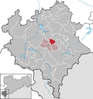
| Location of the municipality of Bergen in the Vogtlandkreis | ||
  |
||

Bergen is a municipality in the Saxon part of the Vogtland . It is centrally located in the Vogtlandkreis and is around eleven kilometers southeast of the district town of Plauen . Together with three other neighboring communities, it forms the Jägerswald administrative association . Bergen has around 1000 inhabitants and was first mentioned in a document in 1267. In addition to the main town, the community is divided into three further sub-towns.
Geography and traffic
Geographical location
Bergen is located in the Saxon part of the historical Vogtland and the natural area Vogtland at 473 m above sea level. NHN . The highest point is at about 516 m above sea level. NHN . The Harzberg on the northern border of the municipality is 541 meters high. Bergen lies between this mountain and the Jägerswald , which begins south of the village and extends in the southeast to the Werda dam (also known as the Geigenbach dam ). The Jägerswald encloses mountains in the south, southeast and west. The forest area is only broken through in the valleys of Trieb and Jahnsgrüner Bach .
In the upper reaches, the Trieb Geigenbach is called, it rises near Grünbach and then flows through the Jägerswald, is dammed in the dam near Werda and then continues its course as a drive through mountains and the Falkenstein district of the same name. At Thoßfell it is then dammed up to the Pöhl dam and later flows into the White Elster . The shoot still has a few smaller tributaries in mountains, which mostly arise in the Jägerswald or on the Harzberg. The Jahnsgrüner Bach has its source to the west of the mountain; it also drains into the Pöhl reservoir via two other small brooks.
The geographical center of the Vogtlandkreis is in Tirpersdorf and is only a few kilometers away from Bergen.
Neighboring communities and local division
Bergen forms its own district , which covers the entire 8.3 km² municipal area. The municipality of Neuensalz with the district of Mechelgrün borders on Bergen in the north . To the northeast is the town of Falkenstein / Vogtl. neighboring, the district of Trieb is the closest. In the east, the municipality of Neustadt adjoins Bergen. The other three neighboring communities together with Bergen form the Jägerswald administrative association. These are Werda in the south, Tirpersdorf in the southwest with the Lottengrün district , and Theuma , which is neighboring to the west.
The districts of Jahnsgrün , Steinigt and Streuberg belong to Bergen, but they have not been officially listed as such since October 1, 2010. Of the 830 hectare district of Bergen, over half (443 hectares) is forested. 72 hectares are settlement and traffic areas, of which 38 hectares are buildings and open spaces, six hectares are recreational areas and 26 hectares are traffic areas. The Bergens cemetery is around one hectare in size. Agricultural areas cover 287 hectares, three hectares are bodies of water. The quarry near Streuberg has a size of eight hectares. The remaining 18 hectares are used for other purposes.
traffic
_Empfangsgeb%C3%A4ude_(2).jpg)
A total of 17 streets are named in Bergen. These are the streets Am Anger, Am Brandteich, Am Forellenteich, Am Forsthaus, Am Harzberg, Am Roten Bühl, Am Streuberg, Am Winkel, Bergstraße, Falkensteiner Straße, Gartenstraße, Mechelgrüner Weg, Plauensche Straße, Poppengrüner Straße, Rosenweg, Theumaer Straße and Thomas-Müntzer-Strasse.
The federal highway 169 runs through Bergen . It connects the cities of Stollberg / Erzgeb. and Plauen and has a connection to the federal motorway 72 (junction Plauen-Ost) via the federal highway 173 near Neuensalz . A drive from Bergen to the center of Plauen takes about 20 minutes. In the other direction, the main road connects Bergen to Falkenstein, in the village the state road 301 branches off in the direction of Poppengrün (to Neustadt / Vogtl.). The Steinigt district is reached via the state road. From Plauenschen Straße, a smaller road leads past the Streuberg through the Jägerswald to Theuma. The suburb of Jahnsgrün is on the main road towards Plauen.
Bergen has had no connection to the rail network since 1972. Before that there was a train station on the Herlasgrün – Oelsnitz line . Today the next train station is in Falkenstein (Vogtl) .
climate
With its humid climate, Bergen is in the temperate climate zone , with a noticeable transition to the continental climate . There is a hilly climate in the valleys of Bergen. Due to the mountain ranges around the Vogtland, there is relatively little rainfall. The nearest weather station is in Hof , to which the following values refer.
The average annual temperature is 7.5 ° C, the maximum monthly average temperature is measured in July at 16.8 ° C, the lowest monthly average temperature with -1.3 ° C in January. The maximum annual temperature is 11.5 ° C, while the minimum temperature is measured at 3.6 ° C. Here, too, the highest and lowest monthly average temperatures are given in July (with maximum temperatures also in June) and January.
The annual rainfall is 749 mm. Most precipitation falls in the months of July (91 mm) and August (77 mm). The month of April recorded the lowest rainfall with 42 mm. There are 198 rainy days in the course of the year . Most of these are recorded in December and March (19 each) and the least in August and September (14 each).
|
Average monthly temperatures and rainfall for mountains
Source: Wetterdienst.de: Climate values of Tirpersdorf (station Hof)
|
|||||||||||||||||||||||||||||||||||||||||||||||||||||||||||||||||||||||||||||||||||||||||||||||||||||||||||||||||||||||||||||||||||||||||||||||||||||||||||||||||||||||||||||||||||||||||||||||||||
history
_(3).jpg)
Local history
The village of Bergen was first mentioned in 1267 as villa Pergen in a deed of donation from Vogts Heinrich von Plauen . In 1418 the place Pergen or already Bergen was called, both name variants continue to alternate until the second half of the 15th century, but come equally from the place in the mountains . The village shape is a forest hoof village , which in 1900 was surrounded by an approximately 831 hectare forest hoof field.
Before Bergen was given independence as a rural community by the Saxon rural community order in 1838 , the place was shaped by the feudal system . The manorial rule was exercised in 1583 by the Lords of Mechelgrün and the Trützschler of Falkenstein. Their rule extended to 29 possessed men and one cottager who lived in Bergen in 1557. During the Thirty Years War , Bergen was plundered several times between 1629 and 1640. The first records of the plague in Bergen date back to 1626. However, the disease peaked in Bergen in 1633 when, according to records, almost 50 people died of the plague in one month. After the end of the Seven Years' War (1756–1763) there were 33 possessed men and nine cottagers in the village who farmed 2 3 ⁄ 4 hooves of 30 bushels each and were proportionally subordinate to the local manor and the manor Oberlauterbach mentioned in 1764 . The manor of the Bergen manor, which belonged to the von Trützschler family for a long time, was built in the 17th century. In 1896 it was bought by the city of Plauen in order to use the usable area for the planned construction of the Geigenbachtalsperre. In the 15th century, Bergen belonged to the Plauen administration and until 1856 to the Electoral Saxon or later royal Saxon office of Plauen . In 1856 Bergen was affiliated to the Falkenstein court office and in 1875 to the Auerbach administration .
The industrialization also resulted in Bergen to a change in the economic structure. Traditionally, agriculture, livestock and handicrafts were common in the village. With the connection to the Herlasgrün – Oelsnitz railway and its stopping point, the development into a typical location for the textile industry began in 1865. The first shuttle embroidery machine in Bergen was put into operation in 1890. In 1903, Bergen received its own power station, which was completed in 1907. Two steam turbines began to generate electricity for the local textile industry. It worked with the Trieb electricity company, which worked with hydropower and had already existed some time before. Soon even the towns on the borders with Bavaria and the Czech Republic were supplied with electricity from Bergen. The capacities were quickly no longer sufficient, so that additional remote power had to be used. In the first ten years after the turn of the century, many textile companies and embroidery companies came into being. There were over 250 embroidery machines in Bergen in 1911. The Bergen stop was elevated to a train station in 1905. In 1913, Bergen was connected to local road traffic with a motor vehicle line from Plauen to Eibenstock .
The number of inhabitants grew as a result of industrialization between 1834 and 1871 from 682 to 1001 inhabitants, in 1910 almost 1900 inhabitants were counted. Of the 1879 inhabitants in 1925, most of them belonged to the Evangelical Lutheran parish in the village. Eight people were of the Catholic denomination, one was Protestant and 24 were non-denominational. The Bergen St. Nicolai Church was built around 1527 and rebuilt in 1870. In 1900 the church tower was rebuilt. The parish of Schönau and Trieb are also part of the Bergen church. 73 Bergen residents died during the First World War . In 1925 the community built its current town hall. Electricity production in Bergen was stopped in the late 1920s for cost reasons, but administration and repair work continued to be carried out here. An address book from 1944 contains 665 entries in Bergen. After the Second World War , which claimed over 140 deaths from Bergen, Saxony came to the Soviet occupation zone and later to the GDR . The affiliation to the administrative center Auerbach, which had existed since 1875, was retained even after the territorial reform in 1952 , which assigned Bergen to the Auerbach district in the Karl-Marx-Stadt district (formerly Chemnitz ).

Rural life in Bergen was now based on the principle of agriculture in the GDR . In addition, uranium mining developed in Bergen. From 1949, successful exploration work was carried out on behalf of the SDAG Wismut . Shortly afterwards, uranium mining began; it was extracted from seven shafts until 1964. The barium uranyl phosphate " Bergenit " found in the Bergen mining area got its name from the place where it was mined. In 1952, it is estimated that around 600 workers were employed in the mining area, five years later there were still around 300. After the end of uranium mining, the importance of the railroad began to decline rapidly, in 1970 passenger traffic and in 1972 goods traffic ceased, the tracks dismantled from 1978.
After the German reunification , Bergen came to the re-established Free State of Saxony. The following regional reforms in Saxony assigned the municipality to the Vogtlandkreis (vehicle registration number: V ) in 1994, which was enlarged in 2008 to include the formerly independent city of Plauen. In the years after 1990 there was another economic upheaval away from the textile industry to handicrafts and services.
On December 25, 1998, the municipalities of Bergen, Theuma, Werda and Tirpersdorf founded the Jägerswald administrative association based in Tirpersdorf. This was followed by the development of a building area for private homes.
In June 2010, the Bergen municipal council decided to start negotiations with Falkenstein about integration and to leave the administrative association. This refused, the district office of the Vogtlandkreis did not approve a merger of the two places. Bergen appealed this decision. At the same time, there are proposals to transform the administrative association into a unified municipality.
Population development

Between 1834 and 1950, Bergen experienced an increase in population from 682 to over 2000. In the 1871 survey, there were more than 1000 people in the town for the first time, and in 1910 it was well over 1500. After the high in 1950, the population fell by 300 by 1964 . After the end of the mining industry, the population continued to fall, and in 1990 just under 1200 people lived in Bergen. Another steady population decline followed, analogous to the other rural communities in East Germany.
|
|
|
|
politics
Municipal council
The Bergen municipal council consists of 10 members and the honorary mayor.
| Political party | 1990 | 1994 | 1999 | 2004 | 2009 |
|---|---|---|---|---|---|
| CDU | 22.1 | - | - | - | - |
| DSU | 7.9 | 15.0 | 41.6 | 21.4 | 7.0 |
| FDP | 3.1 | - | - | - | 2.9 |
| Free voters | - | - | - | 44.4 | 49.4 |
| PDS / Left | - | - | - | 7.5 | 7.7 |
| SPD | 2.9 | - | - | - | - |
| Electoral associations | - | 85.0 | 58.4 | 26.7 | 32.9 |
| Others | 64.0 | - | - | - | - |
- WV Fw : 3
- WVS : 2
- BIG : 1
- FW : 6
Since the municipal council election on May 25, 2014 , the 12 seats of the municipal council have been distributed among the individual groups as follows:
- Free voters (FW): 6 seats
- Voters' association “Your Fire Brigade” (WV Fw): 3 seats
- Voting Association Sport (WVS): 2 seats
- Bergen interest group (BIG): 1 seat
mayor
In the mayoral election on June 12, 1994, Beate Schubert from the Bergen Citizens' Initiative emerged victorious. In the next election on June 10, 2001, the non-party Volkmar Trapp, who was confirmed in office in 2008 and 2015, won. He resigned from office due to illness in January 2018. Günther Ackermann, also non-party, was elected mayor.
At the state level, the municipality is part of the Vogtland 2 constituency , in the case of federal elections the municipality is in the Vogtlandkreis constituency , which corresponds to the district area.
Culture
There is a volunteer fire brigade in Bergen . It is one of a total of seven in the administrative association. The Bergen kindergarten is called “Am Ententeich”. The nearest primary schools are in the communities of Theuma and Werda.
In club life there is a homeland club that was founded in 1992 and had 23 members in August 2012. The history of the Liederkranz men's choir goes back to 1887. It was re-established in 1994 and has about 25 active singers. The sports club Turbine Bergen was founded in 1911 and is active in football. He has two men's and two youth teams as well as a women's team. The venue is located in the east of Bergen on the street Am Anger.
Economy and tourism
In 2010 there were three farms and three construction businesses in Bergen. As of June 30, 2011, 439 employees were employed at the place of residence subject to social security contributions.
For overnight stays there is the Hotel Landhaus Marienstein with 23 beds, the holiday home Neue Scheune with wooden art display and historical carpentry and the restaurant with Pension Streuberg (15 rooms). In 2011, a cycle path was opened on the former railway line between Oelsnitz and Falkenstein, which runs through the forest to the south around Bergen. A signposted hiking trail leads from Bergen to the Geigenbachtalsperre .
Web links
- Private website for the location (JavaScript required for navigation)
- Bergen in the Digital Historical Directory of Saxony
Individual evidence
- ↑ Population of the Free State of Saxony by municipalities on December 31, 2019 ( help on this ).
- ↑ Search for geographical names. In: Service center of the geodata center. Federal Agency for Cartography and Geodesy , accessed on November 19, 2013 .
- ↑ Information for 14 5 23 050 Bergen municipality. In: Regional Register Saxony. State Statistical Office of Saxony, accessed on November 20, 2013 .
- ↑ a b Municipal statistics 2012 for Bergen. In: Regional data, municipal statistics, Saxony. State Statistical Office of Saxony, accessed on November 20, 2013 .
- ↑ Climate and Weather. In: bergen-vogtland.de. Bergen Municipality, accessed November 20, 2013 .
- ↑ Wetterdienst.de: Bergens climate values (Hof station) , database 1991–2010.
- ↑ a b History of the Bergen Church. In: bergen-vogtland.de. Bergen Municipality, accessed November 20, 2013 .
- ↑ The Mechelgrün manor at www.sachsens-schlösser.de
- ↑ The Bergen manor at www.sachsens-schlösser.de
- ↑ a b c Bergen in the Digital Historical Directory of Saxony
- ^ The manor Oberlauterbach on www.sachsens-schlösser.de
- ^ Karlheinz Blaschke , Uwe Ulrich Jäschke : Kursächsischer Ämteratlas. Leipzig 2009, ISBN 978-3-937386-14-0 ; P. 76 f.
- ^ The Auerbach administration in the municipality register 1900
- ↑ a b The power station in Bergen / Vogtland. In: bergen-vogtland.de. Bergen Municipality, accessed November 20, 2013 .
- ↑ a b Brief Chronicle of Bergen. In: bergen-vogtland.de. Bergen Municipality, accessed November 20, 2013 .
- ^ Wilfried Rettig: The railways in Vogtland . tape 1 , p. 115 f .
- ↑ Historic Addressbooks: Entries for the location Bergen (Vogtland). In: adressbuecher.genealogy.net. Computer Genealogy Association , accessed November 19, 2013 .
- ↑ Federal Statistical Office (Ed.): Municipalities 1994 and their changes since 01.01.1948 in the new federal states . Metzler-Poeschel, Stuttgart 1995, ISBN 3-8246-0321-7 .
- ^ Chronicle of the mining work in the Bergen deposit (Wismut). In: bergen-vogtland.de. Bergen Municipality, accessed November 20, 2013 .
- ^ Relevant new formation 7853 Verwaltungsverband Jägerswald. In: Regional Register Saxony. State Statistical Office of Saxony, accessed on November 20, 2013 .
- ↑ In the far distance - the unified community Jägerswald. (Video; no Flash required) In: YouTube . VRFdirekt, accessed November 20, 2013 .
- ↑ Hot Spots situation for Management Association Jägerwald . In: Vogtland Anzeiger . July 13, 2010 ( online ).
- ^ Michael Rademacher: German administrative history from the unification of the empire in 1871 to the reunification in 1990. Auerbach district. (Online material for the dissertation, Osnabrück 2006).
- ↑ Change in the structure of the local community. In: Regional Register Saxony. State Statistical Office of Saxony , October 1, 2010, accessed on November 19, 2013 .
- ↑ a b municipal council election 1994. In: statistik.sachsen.de. State Statistical Office of Saxony, accessed on November 19, 2013 .
- ↑ Municipal council election 1999. In: statistik.sachsen.de. State Statistical Office of Saxony, accessed on November 19, 2013 .
- ↑ Local council election 2004. In: statistik.sachsen.de. State Statistical Office of Saxony, accessed on November 19, 2013 .
- ↑ Local council election 2009. In: statistik.sachsen.de. State Statistical Office of Saxony, accessed on November 19, 2013 .
- ↑ Results of the 2014 municipal council elections
- ↑ https://www.statistik.sachsen.de/wpr_alt/pkg_s10_bmlr.prc_erg_bm_a?p_bz_bzid=BM151&p_ebene=GE&p_ort=14523050
- ↑ Associations and interest groups. In: bergen-vogtland.de. Bergen Municipality, accessed November 20, 2013 .
- ↑ Teams. (No longer available online.) In: turbine-bergen.de. SV Turbine Bergen, archived from the original on March 11, 2013 ; Retrieved November 20, 2013 . Info: The archive link was inserted automatically and has not yet been checked. Please check the original and archive link according to the instructions and then remove this notice.
- ↑ Hotel Landhaus Marienstein. In: landhaus-marienstein.de. Retrieved November 20, 2013 .
- ↑ Historical carpentry. (No longer available online.) In: triebenal.de. Archived from the original on October 28, 2011 ; Retrieved November 20, 2013 . Info: The archive link was inserted automatically and has not yet been checked. Please check the original and archive link according to the instructions and then remove this notice.
- ↑ Rooms and prices. (No longer available online.) In: streuberg.de. Archived from the original on September 17, 2013 ; Retrieved November 20, 2013 . Info: The archive link was inserted automatically and has not yet been checked. Please check the original and archive link according to the instructions and then remove this notice.
Adorf / Vogtl. | Auerbach / Vogtl. | Bad Brambach | Bad Elster | Mountains | Bösenbrunn | Eichigt | Ellefeld | Elsterberg | Falkenstein / Vogtl. | Grünbach | Heinsdorfergrund | Klingenthal | Lengenfeld | Limbach | Markneukirchen | Mill Valley | Hollow hammer | Netzschkau | Neuensalz | Neumark | Neustadt / Vogtl. | Oelsnitz / Vogtl. | Pausa-Mühltroff | Plauen | Pöhl | Reichenbach im Vogtland | Rodewisch | Rosenbach / Vogtl. | Schöneck / Vogtl. | Steinberg | Theuma | Tirpersdorf | Faithful | Triebel / Vogtl. | Weischlitz | Who's there