Chagnon
| Chagnon | ||
|---|---|---|
|
|
||
| region | Auvergne-Rhône-Alpes | |
| Department | Loire | |
| Arrondissement | Saint-Etienne | |
| Canton | Sorbiers | |
| Community association | Saint-Étienne Métropole | |
| Coordinates | 45 ° 32 ' N , 4 ° 33' E | |
| height | 300-518 m | |
| surface | 2.48 km 2 | |
| Residents | 490 (January 1, 2017) | |
| Population density | 198 inhabitants / km 2 | |
| Post Code | 42800 | |
| INSEE code | 42036 | |
| Website | http://www.chagnon42.fr/ | |
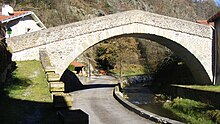
 View of Chagnon |
||
Chagnon is a French municipality with 490 inhabitants (as of January 1 2017) in the department of Loire in the region Auvergne Rhône-Alpes . The municipality belongs to the arrondissement of Saint-Étienne and is part of the canton of Sorbiers (until 2015: canton of La Grand-Croix ).
geography
Chagnon is located about 16 kilometers northeast of the city center of Saint-Étienne on the Durèze River . Chagnon is surrounded by the neighboring communities of Saint-Romain-en-Jarez in the north, Genilac in the east, Lorette in the south and southeast, Cellieu in the southwest and Valfleury in the west.
Population development
| year | 1962 | 1968 | 1975 | 1982 | 1990 | 1999 | 2006 | 2017 |
|---|---|---|---|---|---|---|---|---|
| Residents | 252 | 253 | 231 | 285 | 313 | 411 | 506 | 490 |
| Sources: Cassini and INSEE | ||||||||
Attractions
- Menhir of Chagnon
- Saint-Cyr et Sainte-Julitte church
- medieval bridge from the 11th century
- traditional oven
Web links
Commons : Chagnon - collection of images, videos and audio files

