
Valfleury
| Valfleury | ||
|---|---|---|
|
||
| region | Auvergne-Rhône-Alpes | |
| Department | Loire | |
| Arrondissement | Saint-Etienne | |
| Canton | Sorbiers | |
| Community association | Saint-Étienne Métropole | |
| Coordinates | 45 ° 31 ′ N , 4 ° 30 ′ E | |
| height | 359-820 m | |
| surface | 8.77 km 2 | |
| Residents | 708 (January 1, 2017) | |
| Population density | 81 inhabitants / km 2 | |
| Post Code | 42320 | |
| INSEE code | 42320 | |
| Website | http://www.valfleury.fr/ | |
 View of Valfleury |
||

Valfleury is a French municipality with 708 inhabitants (as of January 1 2017) in the department of Loire in the region Auvergne Rhône-Alpes . It belongs to the arrondissement of Saint-Étienne and the canton of Sorbiers (until 2015: canton of La Grand-Croix ). The inhabitants are called Cellieutaires .
geography
Valfleury is about 14 kilometers northeast of Saint-Étienne . Valfleury is surrounded by the neighboring communities of Saint-Romain-en-Jarez in the north and north-east, Chagnon in the east and south-east, Cellieu in the south and south-east and Saint-Christo-en-Jarez in the west.
Population development
| 1962 | 1968 | 1975 | 1982 | 1990 | 1999 | 2006 | 2017 | |
|---|---|---|---|---|---|---|---|---|
| 373 | 367 | 370 | 437 | 486 | 516 | 584 | 708 | |
| Sources: Cassini and INSEE | ||||||||
Attractions
- Notre-Dame church
- Lachal Castle
- Towers (including clock tower)

Town hall (mairie)
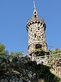
tower


Web links
Commons : Valfleury - collection of images, videos and audio files