
Hailles
| Hailles | ||
|---|---|---|
|
||
| region | Hauts-de-France | |
| Department | Somme | |
| Arrondissement | Montdidier | |
| Canton | Moreuil | |
| Community association | Avre Luce Noye | |
| Coordinates | 49 ° 48 ' N , 2 ° 26' E | |
| height | 32-110 m | |
| surface | 5.07 km 2 | |
| Residents | 422 (January 1, 2017) | |
| Population density | 83 inhabitants / km 2 | |
| Post Code | 80440 | |
| INSEE code | 80405 | |
 Hailles from the road to Dommartin |
||

Hailles ( Picard : Heille) is a northern French municipality with 422 inhabitants (at January 1, 2017) in the department of Somme in the region of Hauts-de-France . The municipality is located in the arrondissement of Montdidier , is part of the Communauté de communes Avre Luce Noye and belongs to the canton of Moreuil .
geography
The municipality in the Amiénois region is located on the left (southern) bank of the Avre opposite the mouth of the Luce and is connected to Thézy-Glimont by a bridge . The distance to Boves is around seven kilometers, to Ailly-sur-Noye around nine kilometers and to Moreuil around eight kilometers.
history
In 1870 there was an unsuccessful franc shooter attack on a Prussian officer. The community received the Croix de guerre 1914-1918 as an award .
Residents
| 1962 | 1968 | 1975 | 1982 | 1990 | 1999 | 2006 | 2010 |
|---|---|---|---|---|---|---|---|
| 226 | 236 | 219 | 263 | 319 | 332 | 384 | 429 |
administration
Jacques Van-Oostende has been mayor ( maire ) since 2001.
Attractions
- Saint-Vast church rebuilt after the First World War
- Mairie

Saint-Vast church
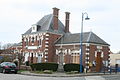
Mairie

