Ith (nature reserve)
|
Ith
|
||
|
Northwest side of the Ith |
||
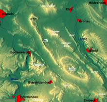
| location | south of Coppenbrügge , southwest of Hameln | |
| surface | 2,715 ha | |
| Identifier | NSG HA 214 | |
| WDPA ID | 389608 | |
| Geographical location | 52 ° 2 ' N , 9 ° 34' E | |
|
|
||
| Setup date | January 31, 2008 | |
| administration | NLWKN | |
The Ith [ iːt ] is a nature reserve on the low mountain range Ith in Lower Saxony . The area has been a nature reserve since January 31, 2008. Responsible lower nature conservation authorities are the districts of Hameln-Pyrmont and Holzminden .
location


The nature reserve is located in the area of Coppenbrügge in the municipality of Salzhemmendorf in the district of Hameln-Pyrmont and in the municipality of Halle in the joint municipality of Bodenwerder-Polle as well as in the municipalities of Dielmissen , Lüerdissen and Holzen and the small town of Eschershausen in the joint municipality of Eschershausen-Stadtoldendorf in the district Holzminden.
The nature reserve with the sign NSG HA 214 is 2,715 hectares . Of this, 1,962.2 hectares are in the Hameln-Pyrmont district and 752.8 hectares in the Holzminden district. The nature reserve is completely part of the FFH area "Ith". A 377 hectare area in the south of the nature reserve is also part of the EU bird sanctuary "Sollingvorland". In the south, the 13.7 hectare “Middle Ith” natural forest reserve , located north of Lüerdissen and designated in 1986, is part of the nature reserve.
The "Ith" nature reserve almost completely surrounds the " Saubrink / Oberberg " nature reserve in the north. In the south it borders on the “ Ithwiesen ” nature reserve . Other nature reserves on the Ith are the nature reserves “ Im Heidsieke ”, “ Sollberg ” and “ Pöttcher Grund ”.
description
The nature reserve lies entirely on the Ith low mountain range as part of the Alfeld mountainous region . The part of the nature reserve in the Hameln-Pyrmont district lies within the Weserbergland Schaumburg-Hameln nature park .
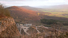
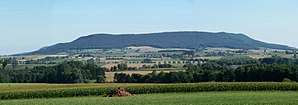
The nature reserve extends over a length of around 22 kilometers and protects the higher elevations including the ridge layers of the Ith, which are occupied by one of the largest limestone beech and canyon forest areas in Lower Saxony. The beech forests in the nature reserve are particularly pronounced as woodruff beech forests, but also as orchid beech forests. They present themselves predominantly as near-natural forest communities. In addition, ravine and hillside mixed forests can be found. Small areas also come non-native coniferous and deciduous tree reforestation ago.
There are numerous source areas and stream valleys within the nature reserve . In addition, rock and stone biotopes can be found, especially in the ridge area of the Ith, in which there are numerous cliff areas, as well as areas with little vegetation. There are isolated grassland areas .
The forests are mainly used as economic or natural forest. The "Mittlerer Ith" natural forest is not used and is left to develop naturally. The non-natural coniferous forest areas are to be developed into naturally occurring forest communities in the long term. The forests in the Ith are characterized by a high proportion of old and dead wood with eyrie and cave trees.
The nature reserve is the habitat of numerous animal species, including the wildcat , great mouse-eared mouse , eagle owl , red kite , gray woodpecker and black stork, which are value-determining according to the Fauna-Flora-Habitat Directive . Many orchids can be found in the forests . There are also blue grasses and various lichens . In spring, larkspurs and anemones bloom in the north of the Ith .
Parts of the nature reserve are used for tourism and as a recreational area. The area is crossed by numerous hiking trails. Some rock areas are approved for climbing.
history
Attempts to place the Ith under nature protection already existed in the first half of the 20th century. As early as 1905, Ernst Rudorff had campaigned for parts of the Nordith to be protected. His daughter Elisabeth Rudorff continued the experiments and has repeatedly submitted applications since the 1920s. In 1939, essential parts of the Ith near Lauenstein were finally designated as a landscape protection area. In 1948 Elisabeth Rudorff applied to the Hameln-Pyrmont district to place parts of the Ith under nature protection. Although there were supporters for this, it was rejected in 1955 after intensive negotiations.
In the 1970s, the state government of Lower Saxony spoke out in favor of protecting the mountains. The reason for this was the quarrying of limestone between the villages of Lauenstein and Harderode, which could ultimately have led to the breakthrough through the ridge of the mountains in this area.
At the beginning of the 1980s, the then district government of Hanover planned to place the Ith under protection. Controversial usage claims prevented an agreement, so that these plans were abandoned around 20 years later. After the Ith was reported to the EU as an FFH area in June 2000 and recognized by the EU in December 2004, the framework conditions changed, which ultimately made it possible to secure it as a nature reserve.
Web links
- Nature reserve "Ith" in the database of the Lower Saxony State Office for Water Management, Coastal and Nature Conservation (NLWKN)
Individual evidence
- ↑ Profile of the Middle Ith natural forest , database of natural forest reserves in Germany, Federal Agency for Agriculture and Food . Retrieved June 21, 2012.
- ↑ The lark spur blossom in the Ith ( memento from March 4, 2016 in the Internet Archive ), experiencing nature in Lower Saxony.
- ^ Ith , IG climbing Lower Saxony e. V. Accessed April 18, 2018.
- ^ Elisabeth Rudorff - a life for the Ith , Institute for Environmental Planning, Leibniz University Hannover . Retrieved April 18, 2018.
- ↑ a b c Ith was declared a nature reserve , press release of the Lower Saxony State Office for Water Management, Coastal and Nature Conservation, February 12, 2008. Retrieved April 18, 2018.
- ↑ FFH area Ith , Hameln-Pyrmont district (PDF, 195 kB). Retrieved April 18, 2018.


