
Le Givre
| Le Givre | ||
|---|---|---|

|
|
|
| region | Pays de la Loire | |
| Department | Vendée | |
| Arrondissement | Les Sables d'Olonne | |
| Canton | Mareuil-sur-Lay-Dissais | |
| Community association | Vendée Grand Littoral | |
| Coordinates | 46 ° 28 ′ N , 1 ° 24 ′ W | |
| height | 2-72 m | |
| surface | 12.42 km 2 | |
| Residents | 508 (January 1, 2017) | |
| Population density | 41 inhabitants / km 2 | |
| Post Code | 85540 | |
| INSEE code | 85101 | |
| Website | http://www.legivre.fr/ | |
 City Hall (Mairie) of Le Givre |
||

Le Givre is a French village with 508 inhabitants (as of January 1 2017) in the department of Vendée in the region of Pays de la Loire ; it belongs to the arrondissement of Les Sables d'Olonne and the canton of Mareuil-sur-Lay-Dissais (until 2015: canton of Moutiers-les-Mauxfaits ). The inhabitants are called Givrais .
geography
Le Givre is about 23 kilometers south of La Roche-sur-Yon . Le Givre is surrounded by the neighboring communities of Saint-Vincent-sur-Graon in the north and east, Saint-Cyr-en-Talmondais in the east, La Jonchère in the south, Le Bernard in the west and south-west and Moutiers-les-Mauxfaits in the north-west.
Population development
| year | 1962 | 1968 | 1975 | 1982 | 1990 | 1999 | 2006 | 2013 |
| Residents | 351 | 282 | 263 | 276 | 265 | 273 | 358 | 467 |
| Source: Cassini and INSEE | ||||||||
Attractions
See also: List of Monuments historiques in Le Givre
- Saint-Martin church, built in the 19th century
- La Brunière Castle, originally a castle from the Hundred Years War, converted into a castle in 1591

Saint Martin Church
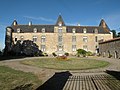
La Brunière Castle

_02.JPG)
literature
- Le Patrimoine des Communes de la Vendée. Flohic Editions, Volume 2, Paris 2001, ISBN 2-84234-118-X , pp. 660-662.
Web links
Commons : Le Givre - collection of images, videos and audio files