
Bois-de-Céné
| Bois-de-Céné | ||
|---|---|---|

|
|
|
| region | Pays de la Loire | |
| Department | Vendée | |
| Arrondissement | Les Sables-d'Olonne | |
| Canton | Challans | |
| Community association | Challans-Gois Communauté | |
| Coordinates | 46 ° 56 ′ N , 1 ° 53 ′ W | |
| height | 0-42 m | |
| surface | 41.89 km 2 | |
| Residents | 2,001 (January 1, 2017) | |
| Population density | 48 inhabitants / km 2 | |
| Post Code | 85710 | |
| INSEE code | 85024 | |
| Website | http://www.boisdecene.fr/ | |

Bois-de-Céné ( Breton : Koed-Keneg ) is a French municipality with 2,001 inhabitants (at January 1, 2017) in the department of Vendée in the region of Pays de la Loire . It belongs to the Arrondissement of Les Sables-d'Olonne and the Canton of Challans . The inhabitants are called Cenéens .
geography
Bois-de-Céné is located in the northwest of the department in the salt marshes of the Falleron , the so-called Marais breton . Bois-de-Céné is surrounded by the neighboring communities of Villeneuve-en-Retz in the north and north-west, Machecoul-Saint-Même in the north and north-east, Paulx in the east and north-east, La Garnache in the south and south-east, Châteauneuf in the south, and Saint-Gervais in the west and south-west and Bouin in the west and north-west.
Population development
| 1962 | 1968 | 1975 | 1982 | 1990 | 1999 | 2006 | 2012 |
|---|---|---|---|---|---|---|---|
| 1,377 | 1,301 | 1,214 | 1,251 | 1,232 | 1,263 | 1,410 | 1,800 |
| Source: Cassini and INSEE | |||||||
Attractions
- Saint-Etienne church, a historic monument since 1926
- Ruins of the Benedictine monastery of Île-Chauvet from the 12th century, destroyed by fire in 1588, monument historique since 1992
- Wall castle from the Middle Ages, monument historique since 1988
- 16th century house, monument historique since 1927

Ile-Chauvet monastery ruins
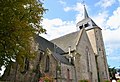
Saint-Etienne church

Wallburg


_-_Bois_de_C%C3%A9n%C3%A9_(Vend%C3%A9e).jpg)
literature
- Le Patrimoine des Communes de la Vendée. Flohic Editions, Volume 1, Paris 2001, ISBN 2-84234-118-X , pp. 91-93.