
Bretignolles-sur-Mer
|
Bretignolles-sur-Mer Brétignolles-sur-Mer |
||
|---|---|---|

|
|
|
| region | Pays de la Loire | |
| Department | Vendée | |
| Arrondissement | Les Sables-d'Olonne | |
| Canton | Saint-Hilaire-de-Riez | |
| Community association | Pays de Saint-Gilles-Croix-de-Vie | |
| Coordinates | 46 ° 38 ′ N , 1 ° 51 ′ W | |
| height | 0-38 m | |
| surface | 27.32 km 2 | |
| Residents | 4,669 (January 1, 2017) | |
| Population density | 171 inhabitants / km 2 | |
| Post Code | 85470 | |
| INSEE code | 85035 | |
| Website | http://www.bretignollessurmer.fr | |
 The church of Bretignolles-sur-Mer |
||

Bretignolles-sur-Mer (sometimes also written Brétignolles-sur-Mer ) is a French commune with 4669 inhabitants (as of January 1, 2017) in the Vendée department in the Pays de la Loire region . It is a seaside resort on the Atlantic coast and belongs to the Côte de Lumière . It belongs to the canton of Saint-Hilaire-de-Riez in the Arrondissement of Les Sables-d'Olonne . The municipality is a member of the Pays de Saint-Gilles-Croix-de-Vie municipal association . The inhabitants call themselves Bretignollais (es) .
geography
La Roche-sur-Yon , the prefecture of the department, is about 35 kilometers east, Les Sables-d'Olonne about 18 kilometers south and Saint-Gilles-Croix-de-Vie about eleven kilometers north. The Jaunay River , a left tributary of the Vie , forms the northern municipal boundary to Givrand and L'Aiguillon-sur-Vie . The Lac du Jaunay reservoir is located about eight kilometers to the northeast.
Neighboring communities
Neighboring municipalities of Bretignolles-sur-Mer are Saint-Gilles-Croix-de-Vie in the north, Givrand in the northeast, L'Aiguillon-sur-Vie and La Chaize-Giraud in the east, Landevie and Brem-sur-Mer in the southeast and Olonne -sur-mer in the south.
traffic
The feeder to the A87 autoroute is about 30 kilometers south-east.
history
Archaeological flint finds and megalithic monuments document a settlement history of several thousand years in the municipality. Between the 12th and 14th centuries, Bretignolles was under British rule several times. In 1854, the municipality ceded part of its territory to Saint-Gilles-sur-Vie, which allowed the latter to expand its seaside activities.
coat of arms
Blazon : On blue in the center a silver coat of arms with three red rafters surmounted by a red cardinal's hat.
Population development
| year | 1962 | 1968 | 1975 | 1982 | 1990 | 1999 | 2008 |
| Residents | 1,303 | 1,534 | 1,920 | 2,029 | 2.165 | 2,687 | 3,900 |
Attractions
- Beaumarchais Castle , a secular building from the 12th century, has been classified as a Monument historique since June 27, 1962
- Dolmen La Pierre Levée de Soubise has been classified as a Monument historique since 1984
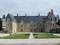
Beaumarchais Castle

Plage de la Sauzaie


.jpg)
literature
- Le Patrimoine des Communes de la Vendée. Flohic Editions, Volume 2, Paris 2001, ISBN 2-84234-118-X , pp. 1000-1002.
Web links
Individual evidence
- ↑ Entry no. PA00110059 in the Base Mérimée of the French Ministry of Culture (French)
- ↑ Entry no. PA00110060 in the Base Mérimée of the French Ministry of Culture (French)