Maha Sarakham (Province)
| Maha Sarakham | |
|---|---|
| มหาสารคาม | |

|
|
| statistics | |
| Capital: | Maha Sarakham |
| Telephone code: | 043 |
| Surface: |
5,291.7 km² 42. |
| Residents: |
939,000 (2009) 20. |
| Population density : | 178 E / km² 14. |
| ISO 3166-2 : | |
| Governor : | |
| map | |
Maha Sarakham ( Thai มหาสารคาม ) is a province ( Changwat ) in Isan , the northeast region of Thailand .
geography
The province is located about 400 kilometers northeast of the capital Bangkok in the heart of the Khorat plateau and is traversed by the Mae Nam Chi (Chi River) .
| Neighboring provinces: | |
|---|---|
| north | Kalasin |
| east | Roi Et |
| south | Surin and Buriram |
| west | Khon Kaen |
history
The province became independent in 1868, before that the area was part of the Roi Et province .
See also: History of Thailand
archeology
Ban Chiang Hian - archaeological site in the valley of Mae Nam Chi.
Economy and Importance
In 2008, the province's gross provincial product was 36,490 million baht .
Data
The table below shows the share of the economic sectors in the gross provincial product in percent.
| Industry | 2006 | 2007 | 2008 |
|---|---|---|---|
| Agriculture | 18.5 | 19.3 | 17.3 |
| Industry | 9.0 | 11.3 | 12.7 |
| Other | 72.5 | 69.4 | 70.0 |
All figures in%
Land use
The following land use is documented for the province:
- Forest area: 207,618 Rai (130 square kilometers), 6.3% of the total
- Agricultural area: 2,418,965 Rai (1211 km²), 73.1% of the total area
- Unclassified area: 680,719 rai (425 km²), 20.6% of the total area
The province of Maha Sarakham has a total of 1,241 wetlands with an area of 169.2 km², which are used more or less intensively for agriculture .
Symbols
The flag of the province shows the seal on a brown stripe in the middle. There is a yellow stripe above and below. The color brown is supposed to symbolize the strength and perseverance of the population, which has to live in a fairly dry climate. The color yellow is the color of the robes of the bhikkhus (Buddhist monks) and symbolizes the faith of the people.
The seal of the province shows a large tree in front of vast rice fields, a symbol of the diverse resources of the province.
The tree of the province is the rain tree ( Albizia lebbeck ). The rain tree symbol was given to the province by Queen Sirikit in 1994. The local flower is the frangipani ( Plumeria alba ).
The motto of Maha Sarakham Province is:
The Buddhist center in the northeast region,
An ancient civilization has emerged here,
The beautiful Thai silk is always famous,
The name of the city is also Takka Sila.
Administrative units
Provincial Administration
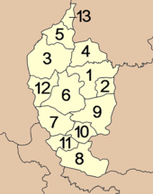
The province is divided into 13 districts ( Amphoe ) . The counties are further subdivided into 133 parishes ( Tambon ) and 1804 villages ( Muban ) .
| Amphoe (counties) | Amphoe (counties) |
|---|---|
|
|
Local administration
A provincial administrative organization ( บริหาร ส่วน จังหวัด , อบ จ for short , Ongkan Borihan suan Changwat ; English Provincial Administrative Organization , PAO) exists for the entire area of the province .
There is a Thesaban Mueang ( เทศบาล เมือง - "city") in the province : Maha Sarakham ( เทศบาล เมือง มหาสารคาม ).
There are also twelve Thesaban Tambon ( เทศบาล ตำบล - "small towns").
literature
- Thailand in Figures 2011 . Nonthaburi: Alpha Research 13 A. 2011. ISBN 978-616752603-4 .
Web links
- Provincial Administration website (in Thai)
- General map of Maha Sarakham Province (names in English and Thai; accessed July 29, 2014)
Individual evidence
- ↑ a b c Thailand in Figures (2011), p. 325
- ↑ Edmund JV Oh, Blake D. Ratner, Simon Bush, Komathi Kolandai and Terence Y. Too (eds.): Wetlands Governance in the Mekong Region: country reports on the legal-institutional framework and economic valuation of aquatic resources . 2005.
- ↑ Department of Provincial Administration : As of 2012 (in Thai)
Coordinates: 16 ° 11 ′ N , 103 ° 18 ′ E


