Mathagen
|
Mathagen
Schalksmühle municipality
Coordinates: 51 ° 14 ′ 13 ″ N , 7 ° 31 ′ 13 ″ E
|
||
|---|---|---|
| Height : | 361 m | |
| Postal code : | 58579 | |
|
Location of Mathagen in Schalksmühle |
||
|
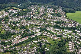
Aerial view of Mathagen, on the right edge minor Siepen
|
||
Mathagen is a district in the municipality of Schalksmühle in the Märkisches Kreis in the administrative district of Arnsberg in North Rhine-Westphalia ( Germany ).
Location and description
The district is located west of the Schalksmühler core town on the plateau between the valleys of the Volme , Hälver and Glör . The district forms with its neighboring districts Mollsiepen and Löh and today a closed settlement area.
Other neighboring towns in the Schalksmühler municipality are in addition to the core town Am Neuenhaus , Ober- , Mittel- and Niederreeswinkel , Auf dem Mühlenfeld , Rotthausen , Asenbach and Herbecke .
history
On October 1, 1912, the still undeveloped area around the place was spun off from the municipality of Halver and assigned to the newly founded municipality of Schalksmühle.
Mathagen was built as a single and multi-family housing estate next to the Löh farm on the green meadow in the 1950s / 1960s as a large new building area in Schalksmühle. Several years later, the Mollsiepen multi-family housing estate followed on the other side of the street from the town center to Rotthausen.


