Hut (Schalksmühle)
|
hut
Schalksmühle municipality
Coordinates: 51 ° 14 ′ 33 ″ N , 7 ° 31 ′ 52 ″ E
|
||
|---|---|---|
| Height : | 222 m | |
| Postal code : | 58579 | |
| Area code : | 02351 | |
|
Location of the hut in Schalksmühle |
||
|
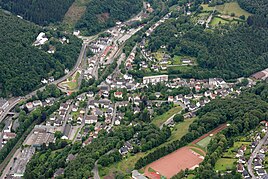
Aerial view of the town center of Schalksmühl. The hut with the old and the newer local area is located in the upper left corner of the picture on the left of federal road 54
|
||
Hut is a district and former industrial site in the community of Schalksmühle in the Märkisches Kreis in the administrative district of Arnsberg in North Rhine-Westphalia ( Germany ).
Location and description
The original hut residential area is located near the Schalksmühler core town in the Volmetal on federal road 54 at the junction of state road 868, which crosses the Volme on a bridge here. Opposite the local area the Hälver flows into the Volme. The Hagen – Dieringhausen railway runs on the other side of the Volme.
In addition to the residential buildings of the original settlement that still exist today, the residential development and a branch of the Märkische Werkstätten des Ev. Johanneswerk on Schulstrasse to the local area.
Other neighboring towns in the Schalksmühler municipality are in addition to the core town Flaßkamp , Neuenbrücke , Klagebach , Klagebacherhammer , Waldesruh , Dahlhausen , Unterwippekühl , Oberklagebach , Asenbach , Am Neuenhaus , Löh and Wippekühl .
history
Until the 19th century, the hut belonged to the western farmers of the parish of Hülscheid . From 1816 the place was part of the municipality of Hülscheid in the mayor's office of Halver in the Altena district and was categorized as a hammer mill according to the location and distance table of the Arnsberg government district .
In 1844 the municipality of Hülscheid with hut was split off from the Halver office and assigned to the newly established Lüdenscheid office . In 1877 the hammer mill on the Volme was called Holthaus Hammer . The water power of the Volme was used in two hammer buildings, the water wheels of which were supplied with water by means of a reservoir.
In the 1870s / 80s, the Hagen – Dieringhausen railway line was built near the town . Also in the second half of the 19th century, the road in Volmetal was laid out, today's federal road 54.
From the Prussian new admission in 1892, the location is unlabeled on the TK25 measuring table , and from the 1921 edition it is marked as hut. The community encyclopedia for the province of Westphalia in 1905 gives a number of 14 inhabitants for hut, who lived in two houses.
In the 1950 / 60s today's Schulstrasse was laid out above the residential area and a school building was erected. The building is now used as a workshop for disabled people .
In 1969, the municipalities of Hülscheid and Schalksmühle were merged to form the large municipality ( unified municipality ) of Schalksmühle in the Altena district and since then Lauenscheiderohl has belonged politically to Schalksmühle, which in 1975 became part of the newly created Märkische Kreis due to the Sauerland / Paderborn law .
In the 1980s, a new Volmebrücke was built for the state road 868 near Huette, which takes all road traffic from the center to the eastern districts.
The reservoir of the hammer mill near Hütte existed into the 21st century and was filled in after 2009. Today there is a park with a playground on the site.
Individual evidence
- ↑ Johann Georg von Viebahn : Local and distance table of the government district Arnsberg, arranged according to the existing state division, with details of the earlier areas and offices, the parish and school districts and topographical information. Ritter, Arnsberg 1841.
- ^ Volmetalbahn: Expropriationskarte at Schalksmühle station, 1877 . North Rhine-Westphalia State Archives, Westphalia department ; Card A no.1624
- ^ Community encyclopedia for the province of Westphalia. Based on the materials from the census of December 1, 1905 and other official sources, edited by the Royal Prussian State Statistical Office. In: Königliches Prussisches Statistisches Landesamt (Hrsg.): Community encyclopedia for the Kingdom of Prussia. Booklet X, 1909, ZDB -ID 1046036-6 .


