
Rosenbach (Upper Lusatia)
| coat of arms | Germany map | |
|---|---|---|
.svg)
|
Coordinates: 51 ° 5 ' N , 14 ° 44' E |
|
| Basic data | ||
| State : | Saxony | |
| County : | Goerlitz | |
| Management Community : | Löbau | |
| Height : | 283 m above sea level NHN | |
| Area : | 23.56 km 2 | |
| Residents: | 1571 (Dec. 31, 2019) | |
| Population density : | 67 inhabitants per km 2 | |
| Postal code : | 02708 | |
| Area code : | 03585 | |
| License plate : | GR, LÖB, NOL, NY, WSW, ZI | |
| Community key : | 14 6 26 470 | |
| Community structure: | 4 districts | |
| Address of the municipal administration: |
Steinbergstrasse 1 OT Herwigsdorf 02708 Rosenbach |
|
| Website : | ||
| Mayor : | Roland Höhne ( CDU ) | |
| Location of the community Rosenbach in the district of Görlitz | ||
  |
||

Rosenbach is a Saxon municipality in the district of Görlitz , which was created in 1994 through the merger of the municipalities of Bischdorf and Herwigsdorf.
Geography and traffic
The municipality of Rosenbach is located in the southern part of the district, around 5 km east of Löbau at an altitude of 237 to 350 m. The national highway 6 and Görlitz-Dresden railway running north of the community. The highest elevation in the municipality is the dominant Rotstein with 455 m .
Local division
![]() Map with all coordinates: OSM | WikiMap
The districts of the municipality are
Map with all coordinates: OSM | WikiMap
The districts of the municipality are
- Bischdorf ( Sorbian : Biskopice ) 51.09261 ° N, 14.74008 ° E
- Oberbischdorf ( Sorbian : Hornje Biskopice ) 51.08818 ° N, 14.75405 ° E
- Steinberg 51.07322 ° N 14.74651 ° E
- Herwigsdorf ( Sorbian : Jěrkecy ) 51.07456 ° N, 14.72943 ° E
history
Lusatian culture
To the period from 1100 to 950 BC Four objects from a deposit found in Herwigsdorf in 1880 under a granite block are dated. There are three bracelets and a spiral made of bronze from the Bronze Age Lausitz culture . These are now in the Zittau Municipal Museum.
Milzener and conquest by German, Polish and Bohemian kings
In the early 8th century the West Slavic Milzener (Upper Sorbian Milčenjo ) immigrated from the area of today's Poland and settled in the Upper Lusatian region north of the wooded mountains in the fertile loess areas of the Lusatian floodplain. The Slavic castle wall on the southern Rotsteingipfel goes back to them, which was designed as a double ring wall at a height of 455 m, consisting of an outer and main castle. This hill fort possibly existed until the 12th century.
Around 932 Heinrich I (912-936) conquered the Milzener and Besunzane territory from Meissen . This made them dependent on interest rates . This will turn this area into a war zone with changing feudal rule for the next 280 years. At the same time, the Meißner and Göda bishops tried to Christianize the Slavs.
After Heinrich's death in 936, they were able to temporarily shake off German rule. Otto I (936 - 973) subjugated it again in 939 and divided the area into Burgwarde , here Dolgawiz . With the division of the Ostmark in 965, the area came to the Mark Meissen. Under Mieszko I of Poland (945–992) the land of the Milzener was considered the border area of his empire. There were repeated unrest until Margrave Ekkehard (985-1002) finally subjugated the area for the Roman-German king in 990.
Thereupon from around 1000 the Milzener were Christianized by the Meißner Bishop Eid (992-1015) starting from Göda . In 1007, King Heinrich II. (1002-1024) gave him the Ostrusna Castle ( Dolgawiz Castle ) with all rights of use in order to involve him more closely in securing the Milzener area. The chapel on the Georgenberg dates from this period (10th / 11th century). Since the 11th century, the Milzener expanded their settlement area by clearing.
In 1002 the Polish Duke Boleslaw Chobry (~ 965-1025) invaded the Milzenerland. Since 1013 the area was part of the Milzener Imperial Fiefs of King Bolesław I of Poland. In 1031 it fell back to the Mark of Meissen. In 1076 it fell to Duke Vratislav II of Bohemia , who as a feudal lord held suzerainty until the 13th century and from the 14th century onwards.

The Burgward Dolgawiz ( Upper Sorbian Dołhaćicy ) with the wall castle belonging to it was owned by the Meissen bishop Herwig (1108–1119) in the 11th century . Bishop Herwig von Meißen started a crusade against the Sorbs in 1119. The Burgward Dolgawiz was mentioned in a document in 1241, as was the Jagdweg zum Hirschberg (Jelenihora, 51.050172 ° N, 14.732991 ° E ) - which in principle formed the nucleus for Herwigsdorf and Bischdorf - in Burgward Dolgowitz, namely in the Upper Lusatian border document from King Wenceslaus of Bohemia (1205–1253).
Land development by peasant colonists and village foundations
Around 1200 the so-called large land expansion reached Upper Lusatia. In the process, rural colonists were specifically recruited from the west, where there was a population surplus. From this time on they also settled in the area of today's villages of Bischdorf and Herwigsdorf. Under the direction of locators, large forest areas were cleared and forest hoof villages were created, which are typical of the high medieval German settlement. Herwigsdorf has such a forest hoofed structure along the Rosenbach. Bischdorf was first mentioned in documents in 1227. Herwigsdorf was mentioned in documents in 1317. Due to the massive immigration of Christian colonists, Christianity became dominant in people's everyday lives.

In the late Middle Ages in the sphere of influence of the Six Cities League
At the beginning of the late Middle Ages, Upper Lusatia and thus Herwigsdorf and Bischdorf belonged to the rule of the Margraves of Brandenburg, and from 1319 and 1396 to the crown of Bohemia. As a political structure, there was no sovereignty there, but the six-city union of the royal cities of Bautzen, Kamenz, Löbau, Görlitz, Lauban and Zittau, concluded in 1347. This federation of bourgeois city governments held the jurisdiction to which the lower nobility (including the robber barons) was subject, and thus ensured a balance of power that was beneficial for trade and craft. The administration of the six-city federation was self-determined and autonomous by larger feudal structures, the change of which did not result in any deeper internal changes. Neighboring kings and princes alternately ruled the six-city league in “personal union” and did not build it into their rulership and administrative structure. In 1469, the Upper Lusatia and the six-city federation even separated independently from the Bohemian King Georg Podiebrad (1420–1471) and chose the Hungarian King Matthias Corvinius (1443–1490) as their sovereign. Through the Peace of Prague in 1635, Upper Lusatia became part of Saxony, but remained territorially independent. Such a strong independence of bourgeois organizational structures was unique in the then Holy Roman Empire .
Due to the population surplus, people migrated to the cities in order to practice handicrafts, which was not possible in the villages. Since the 14th century, the plague reduced the number of inhabitants. In 1429 the Hussite uprising, which started in Prague, reached Upper Lusatia, which was directed against the ruling Catholic Church and the German Emperor.

Early modern times and Reformation
In 1539 Saxony became Protestant and the Reformation was introduced. As a result, the dukes of Saxony increasingly forced rights and possessions from the bishops of Meißen, including the area to which Herwigsdorf and Bischdorf belonged.
Four manors belonged to Herwigsdorf.
1990s
On January 1, 1994, the municipalities of Bischdorf and Herwigsdorf merged to form the municipality of Rosenbach as part of the Saxon municipal area reform. It is named after the Rosenbach , a tributary of the Spree .
Local legends
The legend "The Georgen Chapel on the Rothstein" describes a process that can be localized in the area of the municipality of Rosenbach: On the summit of the Georgenberg there is the ruin of a chapel from the 10th and 11th. Century, which was dedicated to St. George and is said to have been a center of attraction in the Middle Ages. On the Rotstein summit there was a castle that belonged to the robber baron von Rothstein. He led a widowed Polish noblewoman and her servant on a pilgrimage to St. George's Chapel. The servant escaped the situation and asked the knights who were present in Bischdorf to rescue their mistress. They raided the robber baron's castle, but did not find the noblewoman and then destroyed the castle. The Georgenkapelle lost its attraction and fell into disrepair.
Another legend describes the transfer of a treasure guarded by ghosts on the Strohmberg near Weißenberg into a rock cave in the Rotstein massif “without the Schlackenwall”, which sometimes opens.
Another legend describes the creation of the Spitzberg as the result of a love affair between the Landskrone mountain and the Rotstein. The Landskrone, who lives near Görlitz, visited the Rotstein massif, both mountains had sex with each other. The land crown became pregnant and started the way back home, but the birth of the Spitzberg already took place near Pohlsdorf, and there he is still standing.
politics
Municipal council
Since the municipal council election on May 26, 2019 , the 12 seats of the municipal council have been distributed among the individual groups as follows:
- CDU : 8 seats
- TSV Herwigsdorf 1891 e. V. (TSV): 4 seats
coat of arms
Blazon : In gold under a blue shield head, in which two diagonally crossed bishop's staffs, in sheaves between two natural-colored acorns, three green oak leaves, each with a black stem.
Meaning: The colors blue and yellow are the traditional colors of Upper Lusatia. The bishop's staffs symbolize the district of Bischdorf, the acorns and oak leaves represent the district of Herwigsdorf, in which there is an old oak.
Attractions
In and around Rosenbach there are several sights. This includes:
- the Rotstein with the oldest nature reserve in Saxony and a newly built observation tower,
- Remains of a Christian chapel from 10/11. Century on the Georgenberg,
- a church from the 13th century with a choir and star vault in Bischdorf,
- a middle mill (restored water mill ) with the oldest, still functional, inner water wheel in Saxony (diameter 5 m) in Bischdorf,
- a 1000-year-old oak in Herwigsdorf with a chest height of 8.75 m (2016).
- and a church in Herwigsdorf, consecrated in 1495, with a roof ridge tower, baroque pulpit altar, manorial box and painted field ceiling from the 16th century. The church was extensively renovated in 2000 and 2001.
Sons and daughters of the church
- Gottfried Vopelius (1645–1715), Lutheran cantor and teacher, born in Herwigsdorf
- Felix Burkhardt (1888–1973), statistician and business mathematician, born in Herwigsdorf
- Rolf Ludwig (* 1937), mathematician and statistician, born in Herwigsdorf
Picture gallery
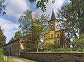
Bischdorf - church and old school

Bischdorf - Hotel and Gasthaus Mittelmühle

Herwigsdorf - Natural Monument Great Oak (1000-year-old oak)

Herwigsdorf - Church with a baroque roof turret

Niederherwigsdorf, Niederhof manor house

Manor house Oberherwigsdorf


_Herrenhaus.jpg)
_Herrenhaus.jpg)
Web links
- Rosenbach community
- Rosenbach (Upper Lusatia) in the Digital Historical Directory of Saxony
- Bischdorf photos
- Herwigsdorf photos
Individual evidence
- ↑ Population of the Free State of Saxony by municipalities on December 31, 2019 ( help on this ).
- ^ Museum de Westlausitz (ed.): Bronze Age. Lusatia 3000 years ago. Kamenz 2007, p. 130
- ↑ a b c Alfred Moschkau: Löbau and its surroundings - a guide through this old four-city, to the Löbauer Berg, Cottmar, Rothstein, Sonneberg, Horken and to the Scala , Verlag Petzold, Dresden 1872 (digitized)
- ↑ a b c d e f g h Siegfried Bayer: The Saxon Way of St. James on the Frankenstrasse - a historical search for traces.
- ↑ Uwe Fiedler: The German East Settlement between the Elbe and the Spree. Bischofswerda, Trebista and the Wesenitz. Bischofswerda 2018
- ^ Heinrich Theodor Flathe : Herwich . In: Allgemeine Deutsche Biographie (ADB). Volume 12, Duncker & Humblot, Leipzig 1880, p. 256.
- ^ Johann Georg Theodor Grasse : 700: The Georgenkapelle on the Rothstein. In: Legends of the Kingdom of Saxony (= fairy tales of the world ). G. Schönfeld, Dresden 1855, pp. 538-539 ( books.google.de ).
- ↑ Results of the 2019 municipal council elections
- ^ Entry in the directory of monumental oaks . Retrieved January 10, 2017
- Location of Bischdorf , Oberbischdorfnach Steinberg & Herwigsdorf according to the historical map:
- Measuring table sheet [4954]: Löbau, 1944 Löbau. - up. 1929, sing. Post 1936. - 1: 25000. - Leipzig, 1944
- online excerpt: kartenforum.slub-dresden

Bad Muskau (Mužakow) | Beiersdorf | Bernstadt ad Eigen | Bertsdorf-Hörnitz | Boxberg / OL (Hamor) | Dürrhennersdorf | Ebersbach-Neugersdorf | Gablenz (Jabłońc) | Goerlitz | Groß Düben (Dźěwin) | Großschönau | Großschweidnitz | Chickens | Hainewalde | Herrnhut | Hohendubrau (Wysoka Dubrawa) | Horka | Jonsdorf | Kodersdorf | Königshain | Kottmar | Krauschwitz (Krušwica) | Kreba-Neudorf (Chrjebja-Nowa Wjes) | Lawalde | Leutersdorf | Löbau | Markersdorf | Mittelherwigsdorf | Mücka (Mikow) | Neißeaue | Neusalza-Spremberg | Niesky | Oderwitz | Olbersdorf | Oppach | Ostritz | Oybin | Quitzdorf am See | Reichenbach / OL | Rietschen (Rěčicy) | Rosenbach | Rothenburg / OL | Loop (slepo) | Schönau-Berzdorf ad Eigen | Schönbach | Schöpstal | Seifhennersdorf | Trebendorf (Trjebin) | Vierkirchen | Forest hooves | White chisel (Wuskidź) | White water (Běła Woda) | Zittau