
Fladungen
| coat of arms | Germany map | |
|---|---|---|

|
Coordinates: 50 ° 31 ' N , 10 ° 9' E |
|
| Basic data | ||
| State : | Bavaria | |
| Administrative region : | Lower Franconia | |
| County : | Rhön-Grabfeld | |
| Management Community : | Fladungen | |
| Height : | 414 m above sea level NHN | |
| Area : | 46.36 km 2 | |
| Residents: | 2212 (Dec. 31, 2019) | |
| Population density : | 48 inhabitants per km 2 | |
| Postal code : | 97650 | |
| Area code : | 09778 | |
| License plate : | NES, CAN, MET | |
| Community key : | 09 6 73 123 | |
| LOCODE : | DE XYA | |
| City structure: | 8 districts | |
City administration address : |
Marktplatz 1 97650 Fladungen |
|
| Website : | ||
| Mayor : | Michael Schnupp (New List 20) | |
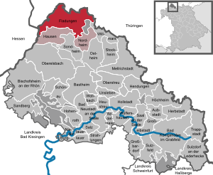
| Location of the town of Fladungen in the Rhön-Grabfeld district | ||
  |
||

Fladungen is a town in the Lower Franconian district of Rhön-Grabfeld , the seat of the Fladungen administrative community and a state-approved resort .
geography
Fladungen is the northernmost city in Lower Franconia. The Oberfladungen district is the northernmost town in the Free State of Bavaria. Fladungen is located in the Main-Rhön region , in the valley of the Streu .
City structure

Fladungen has ten locations, which are divided into eight districts:
|
history
Until the church is planted
In 789, Fladungen was first mentioned in a document from the Fulda monastery . During the time of the tribal duchies, the place was in the Duchy of Franconia . In 1335, Emperor Ludwig the Bavarian granted city rights. The ownership of the city was disputed between the Würzburg bishop and the prince abbot of Fulda. In 1335 noble Heinrich von Fladungen was given the tithe and the mayor's office over Hildenburg . When the office of Fladungen with Hildenburg was pledged to the Counts of Henneberg -Aschach (later called Henneberg-Römhild) in 1435 , Adolf Marschalk von Ostheim was appointed official there. Through an inheritance from the county of Henneberg-Römhild, Fladungen came to the "Münnerstädter Teil" under Count Otto von Henneberg-Römhild in 1468. Fladungen later came back to the Würzburg Monastery by redeeming the pledge . A medieval leprosarium known as the infirmary has been found in Fladungen since 1534 .

In the year 1596 the office Hildenburg was still mentioned, but already in the year 1600 the official lived in Fladungen. As the office of the Hochstift Würzburg, which belonged to the Franconian Imperial Circle , Fladungen was Bavarian for a short time after the secularization in 1803. In 1805 it was given to Archduke Ferdinand of Tuscany to form the Grand Duchy of Würzburg . The imperial knighthood village of Sands of the Lords of Stein came in 1808 through an exchange of territory from the Amt Maßfeld in the Duchy of Saxony-Meiningen to the Grand Duchy of Würzburg. During this time, Weimarschmieden must also have come to Würzburg from the back court of the Lichtenberg district in the Duchy of Saxony-Weimar-Eisenach .
Since the treaties of Paris in 1814 , the town of Fladungen and the surrounding area have finally belonged to Bavaria . In 1818 the political municipality was established.
20th century
Since the opening of the inner German border in 1989, Fladungen is no longer in the border area . In 1992 the city was awarded the Europa Nostra Medal .
Incorporations
On July 1, 1971, in the course of the regional reform in Bavaria, the previously independent communities Sands and Weimarschmieden were incorporated. On January 1, 1972, the Brüchs, Leubach and Oberfladungen were added. Rüdenschenken followed on April 1, 1973. The series of incorporations was completed with the incorporation of Heufurt on May 1, 1978.
Population development
| Population numbers | ||||||||||||||
|---|---|---|---|---|---|---|---|---|---|---|---|---|---|---|
| year | 1840 | 1900 | 1939 | 1950 | 1961 | 1970 | 1987 | 1991 | 1995 | 2005 | 2010 | 2015 | 2017 | 2018 |
| Residents | 2445 | 2141 | 3297 | 3282 | 2676 | 2520 | 2279 | 2372 | 2467 | 2296 | 2169 | 2322 | 2251 | 2248 |
politics
City council
The local elections on March 16, 2014 resulted in the following composition of the city council:
| Party / list | Share of votes | Seats |
| CSU | 24.8% | 4th |
| Free community of voters | 30.4% | 4th |
| Voter block districts | 30.1% | 4th |
| District list Leubach | 14.7% | 2 |
The local elections on March 15, 2020 resulted in the following composition of the city council:
| Party / list | Share of votes | Seats |
| CSU | 14.37% | 2 |
| Free community of voters | 23.43% | 3 |
| Voter block districts | 21.02% | 3 |
| District list Leubach | 13.55% | 2 |
| New list 20 | 27.63% | 4th |
mayor
Michael Schnupp (Neue Liste 20) has been the first mayor since May 1, 2020. He was elected with 55.86% of the valid votes in the 2020 local elections.
The predecessor was Agathe Heuser-Panten (constituency districts). She was the successor to Robert Müller (CSU) from the Heufurt district. He was the successor to Mischa Schmitt (electoral block), who was killed in a car accident. In 2002 he succeeded Herbert Ditzel (Free Voting Association). In 1996, the former mayor Raimund Goldbach retired after 28 years of service.
- 1968–1996: Raimund Goldbach
- 1996–2002: Herbert Ditzel
- 2002–2002: Mischa Schmitt
- 2002–2014: Robert Müller
- 2014–2020: Agathe Heuser-Panten
- Since 2020: Michael Schnupp
coat of arms
|
|
Blazon : "In red under a three-towered silver church facade a wimpergartiger triangular pediment, is in a growing red, blue-clad bishop golden miter, the right a silver sword with his left hand holding an inturned golden crook." |
Town twinning
- Nassenfels in Upper Bavaria
- Nora (Sweden)
- Köyliö (Finland)
- Kõo (Estonia)
Culture and sights


Museums
- Rhön Museum in the former administrative building. Due to renovation work, the museum is currently closed except for occasional special events. The reopening is to take place.
- Franconian open air museum with the Rhön-Zügle (18 km long museum railway from Fladungen via Ostheim to Mellrichstadt ).
Buildings
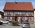
The old town is still largely surrounded by a city wall from 1335 at its original height. The city wall was built with five towers and 16 cavalry towers. All the towers in the city wall and the rider's turrets on the top of the wall have been preserved. The old town has many half-timbered buildings, including the former incumbents hospital. In the old town there is also the prince-bishop's office building and the catholic parish church of St. Kilian.
Architectural monuments

Prince-Bishop's Würzburg Official House from 1628

City parish church Sankt Kilian (1656 to 1659) with a tower of the city wall (1335)

Alley in the old town

Wayside shrine at haystack
Former beneficiary hospital

Gangolf Chapel (1597). Hall building with a second floor as a bell chamber, semicircular apse.


education
- Fladungen has a primary school. 77 students are taught in four classes.
- Fladungen has a day-care center. It has 160 approved places and looks after 123 children (2018).
Sports
- Fladungen has an outdoor swimming pool and a leisure center as well as a sports field. There are also other sports facilities.
traffic
Fladungen is on federal highway 285 . The federal motorway 71 is approx. 20 km away and can be reached via the Mellrichstadt junction . Fladungen is the end point of the Mellrichstadt – Fladungen railway line, which is now only used as a museum railway . In local transport , Fladungen is connected to the DB Frankenbus omnibus network. The buses run to Mellrichstadt Bahnhof , where there is a connection to trains in the direction of Erfurt and Würzburg .
The Hochrhönstrasse connects Fladungen with Bischofsheim in the Rhön .
Personalities
- Jodokus Wagenhauer (1580–1635), auxiliary bishop and rector of the University of Würzburg, was born in Fladungen
literature
- Rhön Biosphere Reserve Bavarian Administration Office (Hrsg.): Historical cultural landscape around Fladungen. (= Rhön Historical Cultural Landscape, Volume 1). Michael Imhof Verlag, Petersberg 2009, ISBN 978-3-86568-468-4 .
- Wolf-Dieter Raftopoulo: Rhön and Grabfeld culture guides. A complete documentation of the old cultural landscapes in terms of art and cultural history. RMd Verlag, Gerbrunn 2017, ISBN 978-3-9818603-7-5 , pp. 102-106.
Web links
- Local government
- Website of the Franconian Open Air Museum Fladungen
- Website of the Rhön Museum Fladungen
- Literature by and about Fladungen in the catalog of the German National Library
- Fladungen: Official statistics of the LfStat
Individual evidence
- ↑ "Data 2" sheet, Statistical Report A1200C 202041 Population of the municipalities, districts and administrative districts 1st quarter 2020 (population based on the 2011 census) ( help ).
- ↑ a b The districts of Fladungen on the website of the city of Fladungen; Information from Stadttouristik Information Fladungen, as of February 26, 2016
- ↑ Mayor. Municipality of Fladungen, accessed on July 4, 2020 .
- ↑ Good business in the Bavarian North Cape. July 27, 2017, accessed May 26, 2020 .
- ↑ https://www.bayerische-landesbibliothek-online.de/orte/ortssuche_action.html?val=1590&attr=590&modus=automat&tempus=20111120/212203&hodie=20160226/103717
- ^ Eva-Maria Wagner: Winding streets, humpback places . In: Die Rhön (= Merian , vol. 17 (1964), issue 4), pp. 19–24, here p. 24.
- ↑ See data from the Society for Leprosy in Medieval Leprosories in Today's Bavaria ( Memento of the original from February 6, 2015 in the Internet Archive ) Info: The archive link was automatically inserted and not yet checked. Please check the original and archive link according to the instructions and then remove this notice.
- ↑ exchange of territory in 1808 Rhon lexicon
- ↑ Weimarschmieden in Rhon lexicon
- ^ Wilhelm Volkert (ed.): Handbook of Bavarian offices, communities and courts 1799–1980 . CH Beck, Munich 1983, ISBN 3-406-09669-7 , p. 520 .
- ^ Federal Statistical Office (ed.): Historical municipality directory for the Federal Republic of Germany. Name, border and key number changes in municipalities, counties and administrative districts from May 27, 1970 to December 31, 1982 . W. Kohlhammer, Stuttgart / Mainz 1983, ISBN 3-17-003263-1 , p. 740 f .
- ↑ Municipal statistics 2014 https://www.statistik.bayern.de/mam/produkte/statistik_kommunal/2019/09673123.pdf
- ^ Bavarian State Office for Statistics
- ↑ Local elections 2020 in the city of Fladungen - overview. Retrieved May 18, 2020 .
- ↑ Entry on Fladungen's coat of arms in the database of the House of Bavarian History
- ^ Rhönmuseum Fladungen: News. Retrieved August 26, 2019 .
- ↑ a b City Fladungen - website

Aubstadt | Bad Königshofen im Grabfeld | Bad Neustadt an der Saale | Bastheim | Bischofsheim in the Rhön | Burglauer | Fladungen | Großbardorf | Großeibstadt | Hausen | Hendungen | Herbstadt | Haystack | Höchheim | Hohenroth | Hollstadt | Mellrichstadt | Niederlauer | Nordheim before the Rhön | Oberelsbach | Top litter | Ostheim before the Rhön | Rödelmaier | Hall on the Saale | Salt | Sandberg | Schönau an der Brend | Sondheim before the Rhön | Stockheim | Radiations | Sulzdorf an der Lederhecke | Sulzfeld | Trappstadt | Unsleben | Willmars | Wollbach | Wülfershausen on the Saale
Unregulated areas in the district of Rhön-Grabfeld Bundorfer Forst |
Burgwallbach Forest |
Forest Schmalwasser-Nord |
Forest Schmalwasser-Süd |
Mellrichstadter Forest |
Steinacher Forest on the right of the Saale |
Sulzfelder Forest |
Weigler