
Unterlamm
|
Unterlamm
|
||
|---|---|---|
| coat of arms | Austria map | |
 |
|
|
| Basic data | ||
| Country: | Austria | |
| State : | Styria | |
| Political District : | Southeast Styria | |
| License plate : | SO (from 1.7.2013; old: FB) | |
| Surface: | 16.73 km² | |
| Coordinates : | 46 ° 59 ' N , 16 ° 3' E | |
| Height : | 285 m above sea level A. | |
| Residents : | 1,250 (January 1, 2020) | |
| Postcodes : | 8352, 8350, 8361 | |
| Area code : | +43 3155 | |
| Community code : | 6 23 72 | |
| NUTS region | AT224 | |
| Address of the municipal administration: |
Unterlamm 100 8352 Unterlamm |
|
| Website: | ||
| politics | ||
| Mayor : | Robert Hammer ( ÖVP ) | |
|
Municipal Council : (2015) (15 members) |
||
| Location of Unterlamm in the district of Southeast Styria | ||
  |
||
 Place view |
||
| Source: Municipal data from Statistics Austria | ||


Unterlamm is a municipality with 1250 inhabitants (as of January 1, 2020) in the south-east of Styria in the district of Southeast Styria .
geography
Geographical location
Unterlamm is located approx. 48 km east of Graz and approx. 13 km east of the district capital Feldbach in the Eastern Styrian hill country . The Lehenbach flows through the village .
Community structure
The municipality includes the following three localities (population in brackets as of January 1, 2020):
- Magland (354)
- Upper Lamb (246)
- Under Lamb (650)
The community consists of the cadastral communities Magland, Oberlamm and Unterlamm.
Incorporations
Magland, Oberlamm and Unterlamm were merged for the first time in 1850 to form the unified municipality of Unterlamm , at the head of which was a municipality leader who represented the municipalities externally and in common matters. Asset management and all internal affairs were the responsibility of the community judge, whom the farmers took turns. In 1928, the united communities were again divided into the independent communities Unterlamm, Magland and Oberlamm. Today's municipality Unterlamm was created in 1951 through the unification of the municipalities.
Neighboring communities
|
Fürstenfeld District Hartberg-Fürstenfeld |
Bad Loipersdorf district Hartberg-Fürstenfeld |
|
.svg)
|
||
| Fehring |
Jennersdorf district Jennersdorf ( Burgenland ) |
history
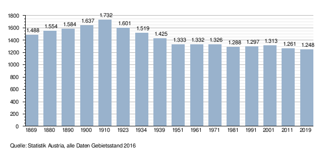
Population development
Culture and sights
- Parish church hl. Heinrich
- Lourdes Marian Grotto
- Joseph Chapel
- Natural pond system with a Celtic tree calendar
- Path of experience for the senses
Natural monuments
There is a protected black poplar in the municipality . See in this regard the list of natural monuments in the district of Southeast Styria .
Economy and Infrastructure
There are numerous businesses in Unterlamm, mainly tourism businesses such as guest houses, pensions and hotels.
politics
mayor
The mayor of the community is Robert Hammer (ÖVP).
The community board also includes the deputy mayor Johann Freißmuth (ÖVP) and the community treasurer Sabine Braun (ÖVP).
Office manager is Alois Hammer.
Municipal council
The municipal council consists of 15 members and has been composed of mandataries from the following parties since the 2015 municipal council election :
The last municipal council elections brought the following results:
| Political party | 2015 | 2010 | 2005 | 2000 | ||||||||
|---|---|---|---|---|---|---|---|---|---|---|---|---|
| Sti. | % | M. | Sti. | % | M. | Sti. | % | M. | Sti. | % | M. | |
| ÖVP | 650 | 72 | 11 | 756 | 81 | 13 | 687 | 80 | 13 | 617 | 70 | 11 |
| SPÖ | 84 | 9 | 1 | 70 | 7th | 1 | 74 | 9 | 1 | 67 | 8th | 1 |
| FPÖ | 174 | 19th | 3 | 112 | 12 | 1 | 99 | 12 | 1 | 123 | 14th | 2 |
| "For Unterlamm" list | not running | not running | not running | 77 | 9 | 1 | ||||||
| Eligible voters | 1,066 | 1.105 | 1,043 | 1,015 | ||||||||
| voter turnout | 86% | 86% | 84% | 88% | ||||||||
coat of arms
The municipal coat of arms was awarded with effect from May 1, 1994.
Description of coat of arms : Divided diagonally from green and black by a golden beveled bar, crossed by a golden lily staff.
Web links
- 62372 - Unterlamm. Community data, Statistics Austria .
- Community website
Individual evidence
- ↑ Municipality of Unterlamm: flower arrangements (accessed on May 11, 2014)
- ↑ Statistics Austria: Population on January 1st, 2020 by locality (area status on January 1st, 2020) , ( CSV )
- ↑ Municipality of Unterlamm: Historical Notes (accessed on May 11, 2015)
- ↑ Economy in Unterlamm (accessed on February 18, 2018)
- ↑ a b Municipality of Unterlamm: Municipal Council (accessed on May 11, 2015)
- ^ Announcements from the Styrian State Archives 47, 1997, p. 43

Bad Gleichenberg |
Bad Radkersburg |
German Goritz |
Edelsbach near Feldbach |
Eichkögl |
Fehring |
Feldbach |
Gnas |
Halbenrain |
Jagerberg |
Kapfenstein |
Kirchbach-Zerlach |
Kirchberg an der Raab |
Kloch |
Mettersdorf am Saßbach |
Mureck |
Paldau |
Pirching am Traubenberg |
Riegersburg |
Sankt Anna am Aigen |
Sankt Peter am Ottersbach |
Sankt Stefan im Rosental |
Straden |
Tieschen |
Unterlamm
61 communities in the former Feldbach district were dissolved between 1945 and 1969. Altenmarkt bei Riegersburg |
Aschau am Ottersbach |
Axbach |
Dirnbach |
Erbersdorf |
Fischa |
Frutten |
Geisselsdorf |
Gleichenberg village |
Gniebing |
Grasdorf |
Grub II |
Gutendorf |
Hague |
Habegg |
Hainsdorf-Brunnsee |
Carrying up |
Höflach |
Hohenbrugg an der Raab |
Jamm |
Kaag |
Karbach |
Clapping |
Koelldorf |
Krennach |
Krottendorf im Sassal |
Lembach near Riegersburg |
Lichtenegg |
Lugitsch |
Maggau # |
Magland |
Mahrensdorf |
Mitterfladnitz |
Muggendorf |
Neustift |
Obergnas |
Oberlamm |
Oberrakitsch |
Oedt near Feldbach |
Petersdorf I |
Petzelsdorf near Fehring |
Plesch |
Rettenbach in East Styria |
Risola |
Rohr an der Raab |
Saaz |
Scheinz |
Slate |
Stang near Hatzendorf |
Sulzbach |
Trössengraben |
Ungerdorf |
Unterlabill # |
Waldsberg |
Waltra |
Weinberg an der Raab |
Weißenbach near Feldbach |
Wetzelsdorf near Kirchbach |
Wilhelmsdorf |
Wörth near Kirchberg an der Raab |
Ziprein 59 communities of the former Radkersburg district were dissolved between 1945 and 1969 Altneudörfl |
Dedenitz |
German Haseldorf |
Diepersdorf |
Dietzen |
Donnersdorf |
Dornau |
On top |
Edla |
Deinendorf am Ottersbach |
Goritz near Radkersburg |
Greater |
Gruisla |
Hard at Straden |
Farmsteads near Deutsch Goritz |
Hummersdorf |
Huerth |
Jörgen |
Karla |
Krobaths |
Kronnersdorf |
Laafeld |
Laasen |
Landorf |
Lichendorf # |
Marktl |
Nägelsdorf |
New set |
Oberpurkla |
Oberschwarza # |
Patzen |
Perbersdorf near Sankt Peter |
Perbersdorf near Sankt Veit # |
Parish village |
Pichla at Mureck # |
Pichla near Radkersburg |
Pölten |
Pridahof |
Radishes |
Rannersdorf am Saßbach |
Rohrbach am Rosenberg |
Salsach |
Schrötten near Deutsch Goritz |
Schwabau |
Seibersdorf near Sankt Veit # |
Sicheldorf |
Siebing # |
Spitz at Deutsch Goritz |
Unterpurkla |
Unterschwarza # |
Waasen am Berg |
Weitersfeld on the Mur # |
Weixelbaum |
Wieden-Klausen |
Wiersdorf |
Wittmannsdorf |
Zehensdorf |
Zelting 50 communities in the district of Southeast Styria were dissolved between 2015 and 2020 Auersbach |
Aug-Radisch |
Bavarian Kölldorf |
Baumgarten near Gnas |
Bierbaum am Auersbach |
Breitenfeld on the Rittschein |
Dietersdorf am Gnasbach |
Precious perennials |
Eichfeld |
Fladnitz im Raabtal |
Frannach |
Frutten-Gießelsdorf |
Glojach |
Gniebing-Weißenbach |
Gosdorf |
Gossendorf |
Grabersdorf |
Hatzendorf |
Hof bei Straden |
Hohenbrugg vineyard |
Johnsdorf-Brunn |
Kohlberg |
Kornberg near Riegersburg |
Krusdorf |
Leitersdorf im Raabtal |
Lödersdorf |
Maierdorf |
Merkendorf |
Mitterlabill # |
Mühldorf near Feldbach |
Murfeld # |
Oberdorf am Hochegg |
Oberstorcha |
Oberstorcha |
Perlsdorf |
Pertlstein |
Petersdorf II |
Poppendorf |
Raabau |
Radkersburg area |
Raning |
Ratschendorf |
Schwarzau in the Schwarzautal # |
Stainz near Straden |
Studenzen |
Trautmannsdorf in East Styria |
Trössing |
Unterauersbach |
Weinburg am Saßbach # |
Zerlach # former community was at the resolution District Leibnitz assigned